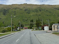
Kingston, New Zealand with Lake Wakatipu in the background (2023)
Kingston was originally named 'St Johns' after police commissioner St. John Branigan. [3]
Demographics
Kingston is described by Statistics New Zealand as a rural settlement. It covers 2.78km2 (1.07sqmi).[1] It is part of the much larger Kingston statistical area.
Kingston settlement had a population of 306 at the 2018 New Zealand census, an increase of 108 people (54.5%) since the 2013 census, and an increase of 159 people (108.2%) since the 2006 census. There were 135 households. There were 156 males and 150 females, giving a sex ratio of 1.04 males per female. The median age was 37.5 years (compared with 37.4 years nationally), with 51 people (16.7%) aged under 15 years, 45 (14.7%) aged 15 to 29, 186 (60.8%) aged 30 to 64, and 24 (7.8%) aged 65 or older.
Ethnicities were 92.2% European/Pākehā, 5.9% Māori, 2.0% Pacific peoples, 2.9% Asian, and 2.0% other ethnicities (totals add to more than 100% since people could identify with multiple ethnicities).
Although some people objected to giving their religion, 61.8% had no religion, 20.6% were Christian, 1.0% were Hindu, 1.0% were Buddhist and 3.9% had other religions.
Of those at least 15 years old, 66 (25.9%) people had a bachelor or higher degree, and 33 (12.9%) people had no formal qualifications. The median income was $49,600, compared with $31,800 nationally. The employment status of those at least 15 was that 201 (78.8%) people were employed full-time, 24 (9.4%) were part-time, and 3 (1.2%) were unemployed.[2]
Kingston statistical area
The Kingston statistical area covers 1,012.54km2 (390.94sqmi)[1] and had an estimated population of 430 as of June 2022,[4] with a population density of 0.4 people per km2.
Kingston had a population of 348 at the 2018 New Zealand census, an increase of 111 people (46.8%) since the 2013 census, and an increase of 147 people (73.1%) since the 2006 census. There were 144 households. There were 180 males and 168 females, giving a sex ratio of 1.07 males per female. The median age was 35.4 years (compared with 37.4 years nationally), with 57 people (16.4%) aged under 15 years, 60 (17.2%) aged 15 to 29, 201 (57.8%) aged 30 to 64, and 27 (7.8%) aged 65 or older.
Ethnicities were 92.2% European/Pākehā, 6.0% Māori, 1.7% Pacific peoples, 4.3% Asian, and 1.7% other ethnicities (totals add to more than 100% since people could identify with multiple ethnicities).
The proportion of people born overseas was 25.9%, compared with 27.1% nationally.
Although some people objected to giving their religion, 62.9% had no religion, 20.7% were Christian, 0.9% were Hindu, 0.9% were Buddhist and 4.3% had other religions.
Of those at least 15 years old, 78 (26.8%) people had a bachelor or higher degree, and 36 (12.4%) people had no formal qualifications. The median income was $49,000, compared with $31,800 nationally. 60 people (20.6%) earned over $70,000 compared to 17.2% nationally. The employment status of those at least 15 was that 228 (78.4%) people were employed full-time, 30 (10.3%) were part-time, and 3 (1.0%) were unemployed.[5]
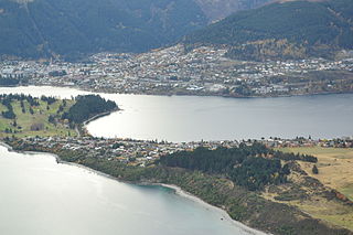
Kingston Station
Transport
The Kingston Flyer historic railway service is closely associated with the town. It operated over a 14 kilometre long preserved section of the former Kingston Branch, which provided a rail link from the city of Invercargill to Kingston for over a century, opening in 1878 and closing in 1979 after a section of track between Garston and Athol was washed out in a storm.
Related Research Articles
Makarora is a small community within the Queenstown-Lakes District of the Otago region of the South Island of New Zealand.
Te Anau is a town in the Southland region of the South Island of New Zealand. In Maori, Te-Anau means the Place of the Swirling Waters. It is on the eastern shore of Lake Te Anau in Fiordland. Te Anau is 155 kilometres north of Invercargill and 171 kilometres to the southwest of Queenstown. Manapouri lies 21 kilometres to the south. Te Anau lies at the southern end of the Milford Road, 117 kilometres to the south of Milford Sound.
Glenorchy is a small settlement at the northern end of Lake Wakatipu in the South Island region of Otago, New Zealand. It is approximately 45 km (28 mi) by road or boat from Queenstown, the nearest large town. There are two pubs, a café and a range of small shops in the town catering mainly to tourists but also to the small resident population. There is also a small airstrip which caters to small planes.
Lumsden is a town in Southland, New Zealand. Lying in a gap in the surrounding hills, Lumsden is the location of a major junction on state highway six. Lumsden is 81 kilometres north of Invercargill, 106 kilometres south of Queenstown, 59 kilometres west of Gore and 77 kilometres east of Te Anau.
Queenstown-Lakes District, a local government district, is in the Otago Region of New Zealand that was formed in 1986. It is surrounded by the districts of Central Otago, Southland, Westland and Waitaki.
Mossburn is a small town in the northern Southland region of New Zealand. It is situated 113 km south of Queenstown, 59 km east of Te Anau and 100 km north of Invercargill. The town is located in a very scenic area, with the mountains of Fiordland creating a beautiful backdrop, with the West Dome and Mt Hamilton being prominent land marks.
Mornington is a suburb of Wellington, New Zealand, on the southern hills behind Brooklyn. It is named after the Duke of Wellington's father, the Earl of Mornington. The original Mornington is in County Meath, and was the Irish seat of the Duke's father. It was named in 1878 from the time when J.F.E. Wright (1827-1891) subdivided his land in the south-west of the city in partnership with Jacob Joseph, and created the suburbs of Mornington and Vogeltown.
Maromaku is a locality in the Northland Region of the North Island of New Zealand. Kawakawa is north, and Towai is southeast. State Highway 1 runs past Maromaku to the north, and the North Auckland Line runs through it.
Tuamarina is a small town in Marlborough, New Zealand. State Highway 1 runs through the area. The Tuamarina River joins the Wairau River just south of the settlement. Picton is about 18 km to the north, and Blenheim is about 10 km to the south.
Luggate is a small town in the South Island of New Zealand. It is located on State Highway 6 between Wānaka and Cromwell, near the junction with State Highway 8A, approximately 15 km from the Wānaka township, just past Wānaka Airport.
Riversdale is a small town in the Southland region of New Zealand.
The Whakatipu Basin is a plain surrounded by mountains in Queenstown Lakes District, in the southern South Island of New Zealand.
St Andrews is a small town in the south Canterbury region of New Zealand's South Island. It is located on State Highway 1 five kilometres south of Pareora and 17 kilometres south of Timaru. It was linked to Timaru by rail in 1876, and grew after the subdivision of the Pareora Run. It remains a rural service town.
Closeburn is a locality in Queenstown-Lakes District in the South Island of New Zealand. It is located a 10-minute drive from Queenstown on the Glenorchy–Queenstown Road.
Arthurs Point is a suburb of Queenstown in the South Island of New Zealand. It is situated near Queenstown Hill and Bowen Peak and is not far from central Queenstown. Another distinctive aspect for the area is that the Shotover Jet company operates jetboats on the Shotover River which passes under the Edith Cavell Bridge.
Lake Hayes Estate is a town nearby to Queenstown in the South Island of New Zealand. It is named after and situated near Lake Hayes; however, the lake is not visible from most parts of the estate. The population of the town at the 2018 census was 2,470. The main access to Lake Hayes Estate is off State Highway 6. To the west is the newer sub division of Shotover Country which can be accessed via Jones Road.
Quail Rise is a residential suburb of Queenstown in the South Island of New Zealand.
Pipitea is a central suburb of Wellington, in the Wellington region of New Zealand's North Island.
Queenstown East is a residential suburb of Queenstown in the South Island of New Zealand. State Highway 6A runs through it.
Sunshine Bay is an inlet of Lake Wakatipu and suburb of Queenstown in the South Island of New Zealand. It is located on the lower slopes of the Ben Lomond mountain, west of Fernhill, on the northern side of the lake.
↑ Miller, Frederick Walter Gascoyne (1949). Golden days of Lake County: the history of Lake County and the boroughs of Queenstown and Arrowtown. Christchurch, NZ: Whitcombe & Tombs. p.62.
This page is based on this Wikipedia article Text is available under the CC BY-SA 4.0 license; additional terms may apply. Images, videos and audio are available under their respective licenses.