
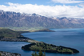
Queenstown is a resort town in Otago in the south-west of New Zealand's South Island. It has an urban population of 15,800.
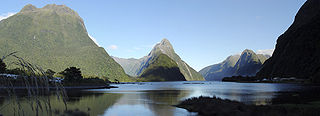
Milford Sound is a fiord in the south west of New Zealand's South Island within Fiordland National Park, Piopiotahi Marine Reserve, and the Te Wahipounamu World Heritage site. It has been judged the world's top travel destination in an international survey and is acclaimed as New Zealand's most famous tourist destination. Rudyard Kipling had previously called it the eighth Wonder of the World. The fiord is most commonly accessed via road by tour coach, with the road terminating at a small village also called Milford Sound.

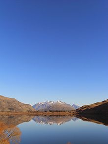
Lake Wānaka is New Zealand's fourth-largest lake and the seat of the town of Wānaka in the Otago region. The lake is 278 meters above sea level, covers 192 km2 (74 sq mi), and is more than 300 m (980 ft) deep.
Ngāi Tahu, or Kāi Tahu, is the principal Māori iwi (tribe) of the South Island. Its takiwā is the largest in New Zealand, and extends from the White Bluffs / Te Parinui o Whiti, Mount Mahanga and Kahurangi Point in the north to Stewart Island / Rakiura in the south. The takiwā comprises 18 rūnanga corresponding to traditional settlements. According to the 2018 census an estimated 74,082 people affiliated with the Kāi Tahu iwi.

Te Wāhipounamu is a World Heritage Site in the south west corner of the South Island of New Zealand.

Wānaka is a popular ski and summer resort town in the Otago region of the South Island of New Zealand. At the southern end of Lake Wānaka, it is at the start of the Clutha River/Mata-Au and is the gateway to Mount Aspiring National Park.

Lake Wakatipu is an inland lake in the South Island of New Zealand. It is in the southwest corner of the Otago region, near its boundary with Southland. Lake Wakatipu comes from the original Māori name Whakatipu wai-māori.

Lake Ellesmere / Te Waihora is a broad, shallow coastal lake or waituna, in the Canterbury region of the South Island of New Zealand. It is directly to the west of Banks Peninsula, separated from the Pacific Ocean by the long, narrow, sandy Kaitorete Spit, or more correctly Kaitorete Barrier. It lies partially in extreme southeastern Selwyn District and partially in the southwestern extension of the former Banks Peninsula District, which now is a ward in the city of Christchurch. The lake holds high historical and cultural significance to the indigenous Māori population and the traditional Māori name Te Waihora, means spreading waters. It has officially had a dual English/Māori name since at least 1938.
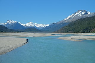
The Dart River flows through rugged forested country in the southwestern South Island of New Zealand. Partly in Mount Aspiring National Park, it flows south-west and then south for 60 kilometres (37 mi) from its headwaters in the Southern Alps and the Dart Glacier, eventually flowing into the northern end of Lake Wakatipu near Glenorchy.
Paterson Inlet / Whaka a Te Wera is a large natural harbour in the eastern coast of Stewart Island/Rakiura, New Zealand, much of which is unspoilt forest.
Kaitiakitanga is a New Zealand Māori term used for the concept of guardianship, for the sky, the sea, and the land. A kaitiaki is a guardian, and the process and practices of protecting and looking after the environment are referred to as kaitiakitanga.
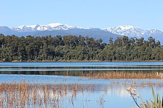
Lake Mahinapua is a shallow lake on the West Coast of New Zealand's South Island. Once a lagoon at the mouth of the Hokitika River, it became a lake when the river shifted its course. Lake Māhinapua was the site of a significant battle between Ngāi Tahu and Ngāti Wairangi Māori, and is regarded by them as a sacred site where swimming and fishing are prohibited. In European times it was part of an inland waterway that carried timber and settlers between Hokitika and Ross until the building of the railway. Today it is protected as a scenic reserve for boating, camping, and hiking.

The Queenstown Trail is a cycle and walking trail funded as one of the projects of the New Zealand Cycle Trail (NZCT) system in Otago, New Zealand. It links the towns of Queenstown, Arrowtown, the suburb of Jack's Point and the area of Gibbston. It is at least 110 km in length but is not linear and instead follows the terrain often near rivers and lakes to link key places in a series of tracks that also access public land. In some places it also passes through private land such as working farms and users are encouraged to stay on the trail. The trail is a joint venture between the Government, Queenstown Lakes District Council and the Queenstown Trails Trust.

Moke Lake is a small lake near the suburb of Closeburn in Queenstown, in the South Island of New Zealand.

Lake Hayes Estate is a town nearby to Queenstown in the South Island of New Zealand. It is named after and situated near Lake Hayes; however, the lake is not visible from most parts of the estate. The population of the town at the 2018 census was 2,470. The main access to Lake Hayes Estate is off State Highway 6. To the west is the newer sub division of Shotover Country which can be accessed via Jones Road.

Kelvin Peninsula is a peninsula on the shore of Lake Wakatipu in New Zealand's Otago Region. The peninsula lies between the main body of Lake Wakatipu and the lake's Frankton Arm and its outlet, the Kawarau River. The centre of Queenstown lies on the opposite shore of the Frankton Arm. The peninsula was formerly called Kelvin Heights Peninsula. The name Kelvin Heights is still used for the Queenstown suburb which sits on the peninsula.
Rākaihautū was the captain of the Uruaokapuarangi canoe and a Polynesian ancestor of various iwi, most famously of Waitaha and other southern groups, though he is also known in the traditions of Taitokerau, and in those of Rarotonga.

Pounamu is a term for several types of hard and durable stone found in southern New Zealand. They are highly valued in New Zealand, and carvings made from pounamu play an important role in Māori culture.
The Tapuae-o-Uenuku / Hector Mountains are a mountain range in the New Zealand region of Otago, near the resort town of Queenstown and just south of the more famous Remarkables. For most of its length, the mountains run adjacent to the southern reaches of Lake Wakatipu, before extending approximately 14 kilometres (8.7 mi) further south, past the glacial moraine at Kingston on the southern end of the lake. On their eastern side, the mountains mark the edge of the Nevis valley, a largely tussocked area which saw significant activity during the Otago Gold Rush of the 1860s. Historically, the mountains were an important mahinga kai for Ngāi Tahu and other local Māori iwi, who used the area to hunt for weka and gather tikumu while visiting the region.


