Roads in Jamaica

Last updated

The roads in Jamaica allow people and goods to traverse the island of Jamaica, which is the third largest in the Caribbean. As of 2011, Jamaica has road network 22,121 kilometres in length. [1]

Contents

Road network

According to the National Works Agency, in 2007 Jamaica had 844 km of arterial roads, 717 km of secondary roads, 3225 km of tertiary roads, 282 km of urban roads, and 10326 km of parochial roads. [2] Using data from 2011, the CIA World Factbook claimed Jamaica has a total road network of 22121 km, 5973 km of which was unpaved and 16148 km of which was paved. [1]

Governing legislation

Various pieces of legislation govern the construction, maintenance, classification, and operation of roads in Jamaica. They include the Road Traffic Act, the Toll Road Act, the Parochial Roads Act, and the Main Roads Act. Government agencies with various responsibilities relating to roads in Jamaica include the Island Traffic Authority, the Toll Authority of Jamaica, and the National Works Agency. [3] [4]

The Spanish Town interchange on the East-West toll road, part of Highway 2000. Spanish Town Interchange- Highway 2000 East West.jpg
The Spanish Town interchange on the East–West toll road, part of Highway 2000.

Motorways

Starting in the late 1990s the Jamaican Government (in cooperation with private investors) embarked on the Highway 2000 project to create a system of motorways, the first such access-controlled roads of their kind on the island. The project seeks ultimately to link the two main cities (Kingston and Montego Bay) and the north coast. It is being undertaken as a series of phases: [5]

On 2009-09-15 Jamaica's prime minister, Bruce Golding, announced to Parliament that Highway 2000 was to be renamed in honour of Usain Bolt. [6] Those intentions were sidelined following a news paper article claiming Bolt had rejected the proposal.

A passage receipt at Vineyards toll booth on the East-West highway. East West Toll Road Passage Receipt.png
A passage receipt at Vineyards toll booth on the East-West highway.

Northern Coastal Highway

1998, the Government of Jamaica and the European Commission signed the financing agreement for the third segment of the Northern Coastal Highway Improvement Project in the amount of €80 million. The Project involves the reconstruction and re-habilitation of approximately 96 km (60 mi) of road between Ocho Rios; St. Ann; and Port Antonio, Portland. Total cost of the project is €105.0 million with the GOJ contributing €25 million for land acquisition and re-settlement as well as the construction of three bridges along the segment.

The entire project consists of approximately 287 km (178 mi) of roadway and is divided into three segments. · Segment 1 – Negril to Montego Bay (approx. 71 km [44 mi]) · Segment 2 – Montego Bay to Ocho Rios (approx. 97 km [60 mi]) · Segment 3 – Ocho Rios to Fair Prospect (approx. 119 km [74 mi]) [7]

Southern Coastal Highway

Approval has been given by Cabinet for the execution of a contract between the government and China Harbour Engineering Company Ltd. for the design, improvement and construction of Sections 1A and 1B of the Southern Coastal Highway Improvement Project. This will involve work from Harbour View to Morant Bay as part of the overall Segment from Harbour View to Port Antonio.

The existing main road along this southern coastal section of the island has been in generally poor condition. The alignment, surface condition, drainage are in need of major improvement.

The Harbour View to Morant Bay section covers some 43 km (27 mi), with Morant Bay to Port Antonio approximately 65 km (40 mi). The work on the Harbour View to Morant Bay leg is estimated to cost approximately US$385 million.

Among the improvement works will be a re alignment of the White Horses Bypass to the south of the town along the sea coast rather than to the north and modification of the Morant Bay Bypass at the western and eastern ends.

A section of the highway will also be constructed to accommodate four lanes and major structures are to be built including 16 bridges, one flyover, and one subway, along with new pipe and box culverts.

Financing for the project is through the China Exim Bank. It is being accommodated in the 5-year Public Sector Investment Programmes covering the period from 2016 to 2021. [8]

Toll Motorways

DesignationFromToViaCommentsLength
Jamaica road T1.svg T1 Kingston Montego Bay (Future) Portmore - Spanish Town - Old Harbour - May Pen - Toll Gate - Williamsfield East-West leg of Highway 2000 84 kilometres (52 mi)
Jamaica road T2.svg T2 Kingston Portmore Port Kingston CausewayAlso known as Portmore Causeway6 kilometres (3.7 mi)
Jamaica road T3.svg T3 Caymanas Saint Ann's Bay Spanish Town - Angels - Linstead - Moneague - Ocho Rios North-South leg of Highway 2000 67 kilometres (42 mi)

A Roads

DesignationFromToViaCommentsLength
Jamaica road A1.svg A1 Kingston Lucea Spanish Town - Bog Walk - Linstead - Ewarton - Moneague - Claremont - Saint Ann's Bay - Falmouth - Montego Bay 243 kilometres (151 mi)
Jamaica road A2.svg A2 Spanish Town Savanna-la-Mar Old Harbour - May Pen - Porus - Mandeville - Santa Cruz - Black River 154 kilometres (96 mi)
Jamaica road A3.svg A3 Kingston Saint Ann's Bay Castleton - A4 junction west of Annotto Bay - Port Maria - Oracabessa - Ocho Rios 101 kilometres (63 mi)
Jamaica road A4.svg A4 Kingston A3 junction west of Annotto Bay Morant Bay - Port Morant - Golden Grove - Hectors River - Manchioneal - Boston Bay - Port Antonio - Hope Bay - Buff Bay Eastern Jamaica coast road.168 kilometres (104 mi)

B Roads

DesignationFromToViaCommentsLength
B1 Cross Roads Buff Bay Newcastle
B2 Bog Walk White Hall Riversdale - Troja - Richmond - Highgate 37 kilometres (23 mi) [9]
B3 May Pen Runaway Bay 85 kilometres (53 mi) [9]
B4 Trout Hall Walderston Frankfield 26 kilometres (16 mi) [9]
B5 Shooters Hill Jackson Town Christiana - Albert Town 71 kilometres (44 mi) [9]
B6 Montpelier Shooters Hill Balaclava - Maggotty - Y.S. River 87 kilometres (54 mi) [9]
B7 Shettlewood Baptist (A2 N of Black River) Happy Grove - Newmarket - Struie 39 kilometres (24 mi) [9]
B8 Ferris Cross (A2 E of Savanna-la-Mar) Reading (A1 W of Montego Bay) Whithorn - Shettlewood - Montpelier 35 kilometres (22 mi) [9]
B9 Lucea Savanna-la-Mar Frome 32 kilometres (20 mi) [9]
B10 Oxford Duncans Clark's Town
B11 Falmouth Green Park (old A1 3.2 kilometres (2 mi) north of Claremont) Clark's Town - Jackson Town - Stewart Town - Brown's Town 68 kilometres (42 mi) [10]
B12 Freetown (A2 E of May Pen) Toll Gate (A2 W of May Pen) Lionel Town Forms a rough semi circle S of May Pen, predominantly near the coast.
B13 Linstead Oracabessa Guy's Hill - Gayle
B15 [11] Montego Bay Falmouth Adelphi - Wakefield - Martha Brae

See also

Related Research Articles

Transport in Jamaica consists of roadways, railways, ship and air transport, with roadways forming the backbone of the island's internal transport system.

<span class="mw-page-title-main">Trans-Canada Highway</span> Transcontinental highway system in Canada

The Trans-Canada Highway is a transcontinental federal–provincial highway system that travels through all ten provinces of Canada, from the Pacific Ocean on the west coast to the Atlantic Ocean on the east coast. The main route spans 7,476 km (4,645 mi) across the country, one of the longest routes of its type in the world. The highway system is recognizable by its distinctive white-on-green maple leaf route markers, although there are small variations in the markers in some provinces.

<span class="mw-page-title-main">British Columbia Highway 19</span> Highway on Vancouver Island in British Columbia

Highway 19 is the main north–south thoroughfare on Vancouver Island from Nanaimo to Port Hardy. It forms part fo the Island Highway along with Highway 1 and Highway 19A. A highway has existed on the Island since about 1912. Originally gravel and rough, the highway was an essential link together with the Esquimalt & Nanaimo Railway. The paved highway first opened in 1953, replacing a stretch of Highway 1 between Nanaimo and Campbell River, finally being extended to the northern tip of the island in the late 1970s. The total length of the highway is 403 kilometres (250 mi).

Route 1 is a highway in the southern part of the Canadian province of New Brunswick. It begins in the west from the Canada–United States border at St. Stephen, and runs east for 239.11 kilometres (148.58 mi) to Route 2 at River Glade.

<span class="mw-page-title-main">Saint Ann Parish</span> Parish of Jamaica

Saint Ann is the largest parish in Jamaica. It is situated on the north coast of the island, in the county of Middlesex, roughly halfway between the eastern and western ends of the island. It is often called "the Garden Parish of Jamaica" on account of its natural floral beauty. Its capital is Saint Ann's Bay. Saint Ann comprises New Seville, the first Spanish settlement in Jamaica.

<span class="mw-page-title-main">Ocho Rios</span> Town in Middlesex, Jamaica

Ocho Rios is a town in the parish of Saint Ann on the north coast of Jamaica, and is more widely referred to as Ochi by locals. Beginning as a sleepy fishing village, Ocho Rios has seen explosive growth in the last decade to become a popular tourist destination featuring duty-free shopping, a cruise-ship terminal, world-renowned tourist attractions and several beaches and acclaimed resorts. In addition to being a port of call for cruise ships, Ocho Rios also hosts cargo ships at the Reynolds Pier for the exportation of sugar, limestone, and in the past, bauxite. The estimated population of the town in 2011 was 16,671, which is nearly 10% of the total population of St. Ann. The town is served by both Sangster International Airport and Ian Fleming International Airport. Scuba diving and other water sports are offered in the town's vicinity.

<span class="mw-page-title-main">Bruce Highway</span> Highway in Queensland, Australia

The Bruce Highway is a major highway in Queensland, Australia. Commencing in the state capital, Brisbane, it passes through areas close to the eastern coast on its way to Cairns in Far North Queensland. The route is part of the Australian National Highway and also part of Highway 1, the longest highway route in Australia. Its length is approximately 1,679 kilometres (1,043 mi); it is entirely sealed with bitumen. The highway is named after a popular former Queensland and federal politician, Harry Bruce. Bruce was the state Minister for Works in the mid-1930s when the highway was named after him. The highway once passed through Brisbane, but was truncated at Bald Hills when the Gateway Motorway became National Highway 1 upon its opening in December 1986.

<span class="mw-page-title-main">Trans-Labrador Highway</span> Highway in Newfoundland and Labrador, Canada

The Trans-Labrador Highway (TLH) is the primary public road in Labrador, the mainland portion of the province of Newfoundland and Labrador, Canada. The highway's total length is 1,149 km (714 mi). The paving of the entire highway was completed in July 2022.

<span class="mw-page-title-main">Ontario Highway 17</span> Ontario provincial highway

King's Highway 17, more commonly known as Highway 17, is a provincially maintained highway and the primary route of the Trans-Canada Highway through the Canadian province of Ontario. It begins at the Manitoba boundary, 50 km (31 mi) west of Kenora, and the main section ends where Highway 417 begins just west of Arnprior. A small disconnected signed section of the highway still remains within the Ottawa Region between County Road 29 and Grants Side Road. This makes it Ontario's longest highway.

<span class="mw-page-title-main">Sangster International Airport</span> International airport in Jamaica

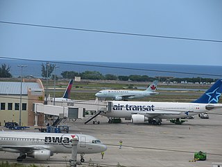
Sangster International Airport is an international airport located 3 mi (4.8 km) east of Montego Bay, Jamaica. The airport is capable of handling nine million passengers per year. It serves as the most popular airport for tourists visiting the north coast of Jamaica. The airport is named after former Jamaican Prime Minister Sir Donald Sangster.

King's Highway 69, commonly referred to as Highway 69, is a provincially maintained north–south highway in the central portion of the Canadian province of Ontario. In conjunction with Highway 400, it links Toronto with the city of Greater Sudbury at Highway 17, via Parry Sound. It is part of the Trans-Canada Highway and the National Highway System. From its southern terminus of Highway 559 at Carling, Highway 69 begins as Highway 400 narrows from a four-laned freeway to a two lane highway. It travels northerly for approximately 68 kilometres (42 mi) to south of the French River before widening back to a divided four lane freeway for approximately 64 kilometres (40 mi) into Sudbury. The final 6 kilometres (3.7 mi) of the route, connecting to Highway 17, is a five lane arterial road that will be converted to freeway as the final phase of the four-laning.

<span class="mw-page-title-main">Saint James Parish, Jamaica</span> Parish of Jamaica

St. James is a suburban parish, located on the north-west end of the island of Jamaica in the county of Cornwall. Its capital is Montego Bay. Montego Bay was officially named the second city of Jamaica, behind Kingston, in 1981, although Montego Bay became a city in 1980 through an act of the Jamaican Parliament. The parish is the birthplace of the Right Excellent Samuel Sharpe, one of Jamaica's seven National Heroes.

Alberta Provincial Highway No. 1, commonly referred to as Highway 1, is a major east–west highway in southern Alberta that forms the southern mainline of the Trans-Canada Highway. It runs from the British Columbia border near Lake Louise through Calgary to the Saskatchewan border east of Medicine Hat. It continues as Highway 1 into both provinces. It spans approximately 534 km (332 mi) from Alberta's border with British Columbia in the west to its border with Saskatchewan in the east. The route is a divided four-lane expressway throughout the province with the exception of a section in central Calgary where it is an arterial thoroughfare carrying four to six lanes. The highway is a freeway between the Sunshine exit near the town of Banff and Home Road in Calgary. Other rural sections have at-grade intersections with interchanges only at busier junctions. Twinning of the final 8.5 km (5.3 mi) of Highway 1 between Lake Louise and the British Columbia border was completed by Parks Canada and opened to traffic on June 12, 2014, making the whole length of Alberta Highway 1 a divided minimum four-lane route.

<span class="mw-page-title-main">Rail transport in Jamaica</span>

The Railways of Jamaica, constructed from 1845, were the second British Colony after Canada's Champlain and St Lawrence Railroad of 1836 to receive a railway system. Construction started only twenty years after the Stockton & Darlington Railway commenced operations in the United Kingdom.

<span class="mw-page-title-main">State Highway 2 (New Zealand)</span> Road in New Zealand

State Highway 2 runs north–south through eastern parts of the North Island of New Zealand from the outskirts of Auckland to Wellington. It runs through Tauranga, Gisborne, Napier, Hastings and Masterton. It is the second-longest highway in the North Island, after State Highway 1, which runs the length of both of the country's main islands.

The Kingston to Montego Bay railway was the main railway in Jamaica, which from 1845 to 1992 linked the capital Kingston with the second city Montego Bay, passing en route most of the major towns.

<span class="mw-page-title-main">Highway 2000</span> Highway system in Jamaica

Highway 2000 is a highway system in Jamaica connecting Kingston, with Ocho Rios and a planned connection to Montego Bay, passing through the parishes of St. Catherine, Saint Ann, Clarendon and proposed sections through St. James, Saint Elizabeth, Westmoreland, Hanover. The highway is operated by the Jamaica Infrastructure Operators and developed by Trans-Jamaica Highway Limited through contractors CHEC and Bouygues Construction.

<span class="mw-page-title-main">Jogeshwari–Vikhroli Link Road</span> Road in Mumbai

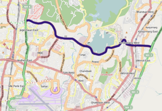
The Jogeshwari–Vikhroli Link Road (JVLR), is a 10.6-kilometre-long (6.6 mi) 6-lane road with a central median in Mumbai which connects the Western Express Highway and Eastern Express Highway providing speedier access from Jogeshwari in the Western Suburbs to Vikhroli in the Eastern Suburbs. It was opened to traffic in 1994, and widened from two to six lanes in 2012 at a cost of 221.45 crore. The under-construction Line 6 of the Mumbai Metro is being constructed on this link road.

<span class="mw-page-title-main">The Church of Jesus Christ of Latter-day Saints in Jamaica</span> Church in Jamaica

The Church of Jesus Christ of Latter-day Saints in Jamaica refers to The Church of Jesus Christ of Latter-day Saints and its members in Jamaica. In 1980, there were 85 members in Jamaica. In 2021, there were 6,718 members in 18 congregations.

References

  1. 1 2 "Jamaica". CIA World Factbook. 2023. Retrieved 25 October 2023.
  2. "National Transport Policy" (PDF). Organisation of American States. Ministry of Transport and Works. October 2007. Archived from the original (PDF) on 24 October 2020. Retrieved 25 October 2023.
  3. "That $4 Roads Act penalty". Jamaica Observer. 30 July 2023. Retrieved 25 October 2023.
  4. "St. Ann PC warns against road encroachments". Jamaica Information Service. 15 July 2011. Retrieved 25 October 2023.
  5. Highway 2000: Project Schedule Retrieved 25 March 2007.
  6. "Usain Bolt gets OJ - Highway 2000 renamed in sprint star's honour". Jamaica Weekly Gleaner. Kingston, Jamaica: Gleaner Company. 3, 022. 20 September 2009.
  7. "Archived copy". www.mhtww.gov.jm. Archived from the original on 14 February 2017. Retrieved 13 January 2022.{{cite web}}: CS1 maint: archived copy as title (link)
  8. "Jamaica House Media Briefing | Office of the Prime Minister". opm.gov.jm. Archived from the original on 21 December 2015. Retrieved 13 January 2022.
  9. 1 2 3 4 5 6 7 8 "Jamaica Road Trips".
  10. Jamaica road map, Texaco, 1972.
  11. UK Directorate of Overseas Surveys 1:50,000 map of Jamaica sheet C, 1959.