Oella is a mill town on the Patapsco River in western Baltimore County, Maryland, United States, located between Catonsville and Ellicott City. It is a 19th-century village of millworkers' homes.

Maryland Route 25, locally known for nearly its entire length as Falls Road, is a state highway in the U.S. state of Maryland. It begins north of downtown Baltimore, just north of Penn Station, and continues north through Baltimore County almost to the Pennsylvania state line. The road passes through the communities of Hampden, Medfield, Cross Keys, and Mount Washington in the city, and Brooklandville and Butler in Baltimore County. The entire length of MD 25 that uses Falls Road—and its county-maintained continuation north to Alesia—is a Maryland Scenic Byway, named the Falls Road Scenic Byway.
The Mill Green Historic District is a National Register of Historic Places listed community located in Harford County, Maryland. The district consists of a small cluster of privately owned historic homes and buildings including a historic mill. The district is located at the junction of Mill Green Road and Prospect Road. Broad Creek flows through the district. The historic district designation was established in 1993.

The Savage Mill Historic District is a national historic district located at Savage, Howard County, Maryland. The district comprises the industrial complex of Savage Mill and the village of workers' housing to the north of the complex.

The Inns on the National Road is a national historic district near Cumberland, Allegany County, Maryland. It originally consisted of 11 Maryland inns on the National Road and located in Allegany and Garrett counties. Those that remain stand as the physical remains of the almost-legendary hospitality offered on this well-traveled route to the west.

Stanton's Mill is a historic grist mill complex located at Grantsville, Garrett County, Maryland, consisting of five interrelated buildings and structures. The Stanton's Mill building dates from about 1797. It is two stories and constructed of heavy timber frame with a gable roof; an addition was constructed in 1890. The complex includes a stone-faced, mid-19th-century timber crib dam and raceway, natural earthen tailrace, and a small, single-span stone arch bridge, dating to 1813, constructed as part of the National Road. Also on the property is a frame storage building, constructed about 1900.

St. James Church is a historic Episcopal church located at Monkton, Baltimore County, Maryland, US.

Williston Mill Historic District is a national historic district in Denton, Caroline County, Maryland. It consists of two historic structures—a grist mill and a miller's house—which share the acreage with the mill stream and race that empties into Mill Creek, a tributary of the Choptank River. The Williston miller's house is a two-story, four-bay single-pile frame dwelling, built originally between 1840 and 1850 with later 19th century expansions. The mill building dates from around 1830–1840, with the two-story section built around 1895. It is one of two grist mills that remain standing in Caroline County.

The McKinstry's Mills Historic District is a national historic district in Union Bridge, located in Carroll and Frederick County, Maryland. The district comprises the entirety of the settlement of McKinstry's Mills, a 26-acre (110,000 m2) hamlet consisting of six separate properties that were owned and developed in the 19th century by the McKinstry family, local millers. At the center is a 3+1⁄2-story grist mill constructed in 1844. Also included are the McKinstry homestead, built between 1825 and 1835; the residence of miller Samuel McKinstry, dated 1849; a store building of 1850; and two other small houses and a variety of outbuildings. There is also a 1908 Warren pony truss bridge.
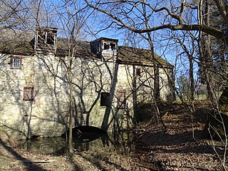
Trovinger Mill, also known as Rohrer's Mill, is a historic grist mill located in Hagerstown, Washington County, Maryland, United States. It was constructed in 1771 of roughly coursed local fieldstone. It is five bays in length with the mill race running underneath it about midway along its broad side. Nearby is the site of a newer mill, which is said to date later than the grain mill. Also present are the abutments of a bridge which crossed the Antietam at the mill as part of an 18th-century road leading from Hagerstown to the Old Forge about one and a half miles upstream. The structure contains much of the original woodwork as well as a significant part of the milling machinery.

Brooklandville House, or the Valley Inn, is a historic restaurant and tavern building, and a former inn, located in Brooklandville, Baltimore County, Maryland. It is a 2+1⁄2-story stone structure facing the former railroad and dating from about 1832. It is associated with the Baltimore and Susquehanna Railroad, which crossed the property just to the south.
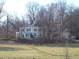
Rockland is a historic home located on Falls Road in Brooklandville, Baltimore County, Maryland. It is a 2+1⁄2-story Greek Revival-influenced house consisting of a three-bay-wide main block, constructed in 1837, with two telescoping additions, a two-bay-wide stage completed in 1852, and a three-bay-wide section built after 1890. The brick structure has been stuccoed and scored to resemble ashlar masonry. Also on the property are a smokehouse, bake oven, a large bank barn, and a late-19th-century frame shed.

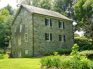
The Owings Upper Mill is a historic grist mill located at Owings Mills, Baltimore County, Maryland, United States. It is a large 3+1⁄2-story brick structure, 50 by 60 feet. The building stands on a low stone foundation, surmounted by a molded brick water table. Two frame extensions were built sometime in the 1880s. The words "EUREKA FLOUR MILL" are worked into the façade in purple brick between the second- and third-story windows. The building is probably the oldest and largest mill surviving in Baltimore County and was the last known project of Samuel Owings, the American Revolutionary War patriot and enterprising merchant.
The Wye Mill is the oldest continuously operated grist mill in the United States, located at Wye Mills, Queen Anne's County and Talbot County, Maryland, United States. It is the earliest industrial site on the Eastern Shore in continuous use; dating to the late 17th century. It is a wood-frame, water-powered grist mill, with a 19th-century 26 HP 10-foot-diameter (3.0 m) Fitz steel overshot wheel. The mill retains nearly all of its late-18th-century equipment. The Wye Mill was one of the first grist mills to be automated with the Oliver Evans process, which is still in use today.

Creagerstown is an unincorporated community in Frederick County, Maryland, United States. It is playfully known by its residents as "4 miles from everywhere" because of its situation at 4 miles (6.4 km) from Thurmont, Woodsboro, Rocky Ridge, and Lewistown.

Franklintown Historic District is a national historic district in Baltimore, Maryland, United States. It is the result of a plan developed in 1832 by William H. Freeman (1790–1863), a local politician and entrepreneur. His plan evolved gradually over the course of several decades and owes its success to his untiring promotion of the village. The central feature is an oval plan with radiating lots around a central wooded park. The district includes an old stone grist mill known as Franklin Mill, the innovative radiating oval plan, and the associated hotel and commercial area. The key residential buildings are excellent examples of the "I"-house form and display steeply pitched cross gables found in vernacular rural buildings throughout much of Maryland.
Old West Baltimore Historic District is a national historic district in Baltimore, Maryland, United States. It is primarily a row house neighborhood of approximately 175 city blocks directly northwest of downtown Baltimore. The district includes other housing from grand mansions to alley houses, as well as churches, public buildings, commercial buildings, and landscaped squares. Pennsylvania Avenue, the main street of the community, features a later 20th century municipal market house. Within the district are civic monuments that relate to Baltimore's premier historic African-American community. Such noteworthy figures as Supreme Court Justice Thurgood Marshall, Congressman Parren Mitchell, jazz artist Cab Calloway, civil rights leader Lillie Mae Carroll Jackson, and Carl Murphy, editor of the Baltimore Afro-American newspaper, lived and / or worked in the area.

Green Spring Valley Historic District is a national historic district near Stevenson in Baltimore County, Maryland, United States. It is a suburban area of Baltimore that acquires significance from the collection of 18th, 19th, and early 20th century buildings. The park-like setting retains a late 19th-early 20th century atmosphere. At the turn of the 20th century, the Maryland Hunt Cup and the Grand National Maryland steeplechase races were run over various parts of the valley. The Maryland Hunt Cup, which began as a competition between the Green Spring Valley Hunt and the Elkridge Hunt, traditionally started at Brooklandwood, the previous home of Charles Carrol of Carrollton with the finish across Valley Road at Oakdene, at that time the home of Thomas Deford, which remains a private residence
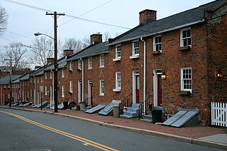
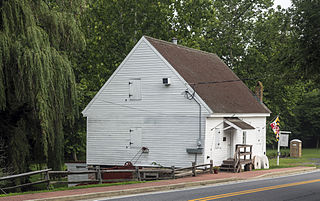
Ellicott's Mills Historic District is a national historic district at Oella, Baltimore County, Maryland, United States. It is on the east bank of the Patapsco River, opposite Ellicott City. This historic district designation relates to the industrial operations of the Ellicott family from the 1770s through the mid-19th century. It consists of the sites of historic buildings including: an 18th-century building, a section of an 18th-century mill incorporated in a 20th-century factory, a 19th-century tavern, 19th-century workers housing, and an 1859 Italianate villa built by John Ellicott. Historically, these industrious mills were served by the major east–west route in Maryland during the early 19th century, the old National Pike. Also in the district is the mammoth multi-story Wilkins-Rogers Company flour plant, which is located on the site of the 1792 Ellicott Flour Mill, the first merchant flour mill in the United States.

Whitaker's Mill Historic District is a national historic district near Joppa, Harford County, Maryland, United States. It includes three early- to mid-19th-century buildings: the 2+1⁄2-story rubble stone Whitaker's Mill built in 1851, the 1+1⁄2-story rubble stone miller's house, and the log-and-frame Magness House, begun about 1800 as the miller's house for the first mill on the site. The district also includes an iron truss bridge known as Harford County Bridge No. 51, constructed in 1878, and the oldest such span in the county. The grist mill closed operations about 1900.


