
The Historic Columbia River Highway is an approximately 75-mile-long (121 km) scenic highway in the U.S. state of Oregon between Troutdale and The Dalles, built through the Columbia River Gorge between 1913 and 1922. As the first planned scenic roadway in the United States, it has been recognized in numerous ways, including being listed on the National Register of Historic Places, being designated as a National Historic Landmark by the U.S. Secretary of the Interior, being designated as a National Historic Civil Engineering Landmark by the American Society of Civil Engineers, and being considered a "destination unto itself" as an All-American Road by the U.S. Secretary of Transportation. The historic roadway was bypassed by the present Columbia River Highway No. 2 from the 1930s to the 1950s, leaving behind the old two-lane road. The road is now mostly owned and maintained by the state through the Oregon Department of Transportation as the Historic Columbia River Highway No. 100 or the Oregon Parks and Recreation Department as the Historic Columbia River Highway State Trail.

The Rogue River in southwestern Oregon in the United States flows about 215 miles (346 km) in a generally westward direction from the Cascade Range to the Pacific Ocean. Known for its salmon runs, whitewater rafting, and rugged scenery, it was one of the original eight rivers named in the Wild and Scenic Rivers Act of 1968. Beginning near Crater Lake, which occupies the caldera left by the explosive volcanic eruption and collapse of Mount Mazama, the river flows through the geologically young High Cascades and the older Western Cascades, another volcanic province. Further west, the river passes through multiple exotic terranes of the more ancient Klamath Mountains. In the Kalmiopsis Wilderness section of the Rogue basin are some of the world's best examples of rocks that form the Earth's mantle. Near the mouth of the river, the only dinosaur fragments ever discovered in Oregon were found in the Otter Point Formation, along the coast of Curry County.

Cape Blanco is a prominent headland on the Pacific Ocean coast of southwestern Oregon in the United States, forming the westernmost point in the state. Cape Blanco extends farther west than any point of land in the contiguous United States except portions of the Olympic Peninsula in Washington, including Cape Alava, the true westernmost point. The cape is part of Cape Blanco State Park and is the location of the Cape Blanco Light, first lit in 1870.

The Yaquina River is a stream, 59 miles (95 km) long, on the Pacific coast of the U.S. state of Oregon. It drains an area of the Central Oregon Coast Range west of the Willamette Valley near Newport.

Rocky Creek State Scenic Viewpoint is a state park in Lincoln County in northwestern Oregon, United States. Administered by the Oregon Parks and Recreation Department, the 59-acre (24 ha) park lies along a bluff between Whale Cove and Rocky Creek. The park extends south along the Otter Crest Loop Road to the Rocky Creek Bridge.

Union Creek is a 15-mile (24 km) long tributary of the Rogue River in the U.S. state of Oregon. Beginning west of Union Peak in the Cascade Range, it flows through the Rogue River – Siskiyou National Forest to meet the Rogue at Union Creek and the Union Creek Historic District.
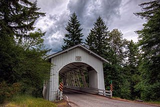
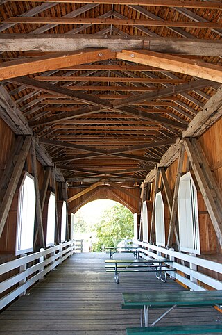
The Deadwood Creek Bridge is a covered bridge in western Lane County in the U.S. state of Oregon. Built in 1932, the 105-foot (32 m) Howe truss structure carries Deadwood Loop Road over Deadwood Creek. The crossing lies upstream of the rural community of Deadwood in the Siuslaw National Forest of the Central Oregon Coast Range. The bridge was added to the National Register of Historic Places in 1979.
Thomas Creek is a stream, about 35 miles (56 km) long, in Linn County in the U.S. state of Oregon. Beginning in Willamette National Forest on the western slopes of the Cascade Range, the creek flows generally west through Santiam State Forest and farmland to meet the South Santiam River west of Scio.
Tenmile Creek is a stream in Lane County, in the U.S. state of Oregon. It flows west from the Siuslaw National Forest in the Oregon Coast Range into the Pacific Ocean at Stonefield Beach State Recreation Site, about 6 miles (10 km) south of Yachats.

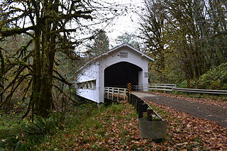
The Horse Creek Bridge was a covered bridge near the unincorporated community of McKenzie Bridge in Lane County in the U.S. state of Oregon. Built in 1930, the structure, 105 feet (32 m) long, carried Horse Creek Road over Horse Creek. The creek is a tributary of the McKenzie River.

The Drift Creek Bridge is a covered bridge in Lincoln County in the U.S. state of Oregon. Built in 1914, the structure originally carried Drift Creek County Road over Drift Creek. The creek flows into Siletz Bay of the Pacific Ocean south of Lincoln City.
Drift Creek is a tributary, about 18 miles (29 km) long, of Siletz Bay in the U.S. state of Oregon. The creek begins near Stott Mountain in the Central Oregon Coast Range in Lincoln County and follows a winding course generally west through the Siuslaw National Forest to enter the bay south of Lincoln City on the Pacific Ocean. It passes under U.S. Route 101 just before reaching the bay.

Rocky Creek Bridge No. 01089, also known as Ben Jones Bridge, is a concrete highway bridge spanning Rocky Creek along the Pacific Ocean coast of the U.S. state of Oregon. The bridge crosses a gorge near the creek's mouth, about 2 miles (3 km) south of Depoe Bay in Lincoln County. Built in 1927, the bridge originally carried U.S. Route 101 over the creek. After a stretch of the highway was relocated to make it straighter, the abandoned piece of the old highway became Otter Crest Loop Road, a local road west of the new highway.

Big Creek is a stream that enters the Pacific Ocean along the coast of Lane County in the U.S. state of Oregon. Beginning at Saddle Mountain Spring in the Central Oregon Coast Range, it flows generally west through the Siuslaw National Forest to the ocean north of Heceta Head. Near its mouth, it passes under Big Creek Bridge, which carries U.S. Route 101.

Cape Creek is a stream that enters the Pacific Ocean along the coast of Lane County in the U.S. state of Oregon. Beginning near Herman Peak in the Central Oregon Coast Range, it flows generally west through the Siuslaw National Forest to the ocean at Heceta Head. The creek's named tributaries are North Fork Cape Creek and, further downstream, Wapiti Creek.
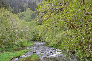
Deadwood Creek is a tributary of Lake Creek in the Siuslaw River basin in Lane County in the U.S. state of Oregon. Beginning near Taylor Butte in the Central Oregon Coast Range, it meanders generally southwest through the Siuslaw National Forest to meet the larger creek at the rural community of Deadwood. This is 5 miles (8 km) from Lake Creek's confluence with the river near Swisshome and 34 miles (55 km) by water from the Siuslaw River's mouth on the Pacific Ocean at Florence.

Lake Creek is a major tributary of the Siuslaw River in Lane County in the U.S. state of Oregon. On average, the 40-mile (64 km) long creek contributes about a third of the lower Siuslaw's water volume.

Fall Creek is a 34-mile (55 km) tributary of the Middle Fork Willamette River in Lane County in the U.S. state of Oregon. Beginning in the Cascade Range, the creek flows generally west through the Willamette National Forest to enter the Middle Fork upstream of Jasper, southeast of Springfield and Eugene.
Ritner Creek is a tributary of the Luckiamute River in Polk County in the U.S. state of Oregon. The creek begins near Bald Mountain in the Central Oregon Coast Range and flows generally southeast to meet the Luckiamute southwest of Pedee and north of Kings Valley. The confluence is 31 miles (50 km) upstream of the Luckiamute's mouth on the Willamette River. Named tributaries of Ritner Creek from source to mouth are Sheythe, Love, Clayton, and Kinsey creeks.

Lost Creek is a tributary of the Middle Fork Willamette River in the U.S. state of Oregon. It begins in the Cascade Range foothills between Dorena Lake and Lookout Point Lake and flows generally north to meet the river downstream of Lowell. Along the way, it passes by the rural community of Dexter, then under Oregon Route 58, and through part of Elijah Bristow State Park. Named tributaries of Lost Creek from source to mouth are Guiley, Gossage, Carr, Middle, Anthony, and Wagner creeks.

