Roopville, Georgia Last updated March 29, 2025
Town in Georgia, United States
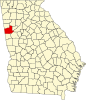
Roopville is a town in Carroll County , Georgia , United States. The population was 231 in 2020, up from 218 at the 2010 census. [ 4]
History Roopville was founded in 1881 by John K. Roop, and named for him. [ 5] The Georgia General Assembly incorporated Roopville as a town in 1885. [ 6]
Demographics As of the census of 2000, there were 177 people, 75 households, and 57 families residing in the town. [ 2] By the 2020 census , its population grew to 231.
References ↑ "2020 U.S. Gazetteer Files" . United States Census Bureau. Retrieved December 18, 2021 . 1 2 "U.S. Census website" . United States Census Bureau . Retrieved January 31, 2008 . ↑ "US Board on Geographic Names" . United States Geological Survey . October 25, 2007. Retrieved January 31, 2008 . 1 2 "Geographic Identifiers: 2010 Demographic Profile Data (G001): Roopville town, Georgia" . U.S. Census Bureau, American Factfinder. Archived from the original on February 12, 2020. Retrieved July 18, 2014 . ↑ Memoirs of Georgia 439. ↑ Acts Passed by the General Assembly of Georgia 391. ↑ "US Gazetteer files: 2010, 2000, and 1990" . United States Census Bureau . February 12, 2011. Retrieved April 23, 2011 . ↑ "Census of Population and Housing" . Census.gov. Retrieved June 4, 2015 .
This page is based on this
Wikipedia article Text is available under the
CC BY-SA 4.0 license; additional terms may apply.
Images, videos and audio are available under their respective licenses.