Roosevelt, Minnesota

Last updated
Roosevelt
Roseau County Minnesota Incorporated and Unincorporated areas Roosevelt Highlighted.svg
Location of Roosevelt, Minnesota
Coordinates: 48°48′13″N95°5′51″W / 48.80361°N 95.09750°W / 48.80361; -95.09750
Country United States
State Minnesota
Counties Roseau, Lake of the Woods
Area
[1]
  Total1.03 sq mi (2.66 km2)
  Land1.03 sq mi (2.66 km2)
  Water0.00 sq mi (0.00 km2)
Elevation
1,161 ft (354 m)
Population
 (2020)
  Total153
  Density148.98/sq mi (57.53/km2)
Time zone UTC-6 (Central (CST))
  Summer (DST) UTC-5 (CDT)
ZIP codes
56673, 56682
Area code 218
FIPS code 27-55438
GNIS feature ID0650236 [2]

Roosevelt is a city in Lake of the Woods and Roseau counties in the State of Minnesota. The population was 151 at the time of the 2010 census. [3]

Contents

History

A post office called Roosevelt has been in operation since 1901. [4] Roosevelt also features a full service grocery store called Knutson Grocery that has been in operation for over 100 years. [5] The city was named for Theodore Roosevelt the 26th president of the United States. [6]

Geography

According to the United States Census Bureau, the city has a total area of 1.04 square miles (2.69 km2), all land. [7] Most of the city lies in Roseau County, with only a tiny percentage in Lake of the Woods County.

Roosevelt is located along Minnesota State Highway 11.

Demographics

Historical population
CensusPop.
1910 252
1920 2769.5%
1930 2874.0%
1940 3045.9%
1950 228−25.0%
1960 145−36.4%
1970 104−28.3%
1980 12419.2%
1990 18045.2%
2000 166−7.8%
2010 151−9.0%
2020 1531.3%
U.S. Decennial Census [8]
2012 Estimate [9]

2010 census

As of the census [10] of 2010, there were 151 people, 61 households, and 42 families living in the city. The population density was 145.2 inhabitants per square mile (56.1/km2). There were 77 housing units at an average density of 74.0 per square mile (28.6/km2). The racial makeup of the city was 97.4% White, 2.0% Native American, and 0.7% from two or more races. Hispanic or Latino of any race were 1.3% of the population.

There were 61 households, of which 26.2% had children under the age of 18 living with them, 54.1% were married couples living together, 6.6% had a female householder with no husband present, 8.2% had a male householder with no wife present, and 31.1% were non-families. 23.0% of all households were made up of individuals, and 9.8% had someone living alone who was 65 years of age or older. The average household size was 2.48 and the average family size was 2.86.

The median age in the city was 45.2 years. 25.8% of residents were under the age of 18; 2.6% were between the ages of 18 and 24; 21.2% were from 25 to 44; 39.8% were from 45 to 64; and 10.6% were 65 years of age or older. The gender makeup of the city was 57.0% male and 43.0% female.

2000 census

As of the census of 2000, there were 166 people, 63 households, and 48 families living in the city. The population density was 160.7 inhabitants per square mile (62.0/km2). There were 67 housing units at an average density of 64.9 per square mile (25.1/km2). The racial makeup of the city was 100.00% White.

There were 63 households, out of which 36.5% had children under the age of 18 living with them, 57.1% were married couples living together, 7.9% had a female householder with no husband present, and 23.8% were non-families. 17.5% of all households were made up of individuals, and 3.2% had someone living alone who was 65 years of age or older. The average household size was 2.63 and the average family size was 3.02.

In the city, the population was spread out, with 26.5% under the age of 18, 9.0% from 18 to 24, 31.9% from 25 to 44, 24.7% from 45 to 64, and 7.8% who were 65 years of age or older. The median age was 39 years. For every 100 females, there were 124.3 males. For every 100 females age 18 and over, there were 114.0 males.

The median income for a household in the city was $31,875, and the median income for a family was $35,625. Males had a median income of $27,292 versus $23,036 for females. The per capita income for the city was $15,656. About 8.5% of families and 12.5% of the population were below the poverty line, including 11.4% of those under the age of eighteen and none of those 65 or over.

Related Research Articles

<span class="mw-page-title-main">Roseau County, Minnesota</span> County in Minnesota, United States

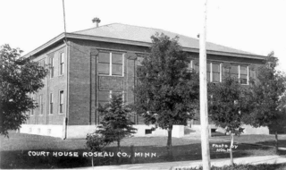
Roseau County is a county in the northwestern part of the U.S. state of Minnesota, along the Canada–US border. As of the 2020 census, the population was 15,331. Its county seat is Roseau. Roseau County borders the Canadian province of Manitoba.

Dewey Township is a township in Roseau County, Minnesota, United States. The population was 114 at the 2000 census. Dewey is in the 7th congressional district of Minnesota and is represented by Democrat Collin Peterson.

<span class="mw-page-title-main">Greenbush, Minnesota</span> City in Minnesota, United States

Greenbush is a city in Roseau County, Minnesota, United States. The population was 719 at the 2010 census.

Mickinock Township is a township in Roseau County, Minnesota, United States. The population was 302 at the 2000 census.

Moose Township is a township in Roseau County, Minnesota, United States. The population was 134 at the 2000 census.

Nereson Township is a township in Roseau County, Minnesota, United States. The population was 69 at the 2000 census.

<span class="mw-page-title-main">Roseau, Minnesota</span> City in Minnesota, United States

Roseau is a city in, and the county seat of, Roseau County, Minnesota. Its population was 2,744 at the time of the 2020 census.

Stokes Township is a township in Roseau County, Minnesota, United States. The population was 229 at the 2000 census.

<span class="mw-page-title-main">Strathcona, Minnesota</span> City in Minnesota, United States

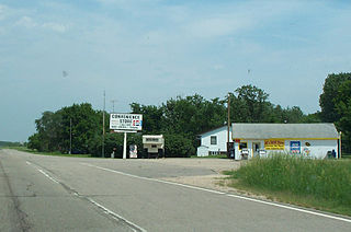
Strathcona is a city in Roseau County, Minnesota, United States. The population was 44 at the 2010 census.

<span class="mw-page-title-main">Roscoe, Minnesota</span> City in Minnesota, United States

Roscoe is a city in Stearns County, Minnesota, United States. The population was 102 at the 2010 census. It is part of the St. Cloud Metropolitan Statistical Area. On December 7, 2016, Donald Kennith Albrecht was sworn in as mayor of Roscoe.

<span class="mw-page-title-main">Badger, Minnesota</span> City in Minnesota, United States

Badger is a city in Skagen Township of Roseau County, Minnesota, United States. The population was 375 at the 2010 census.

Barto Township is a township in Roseau County, Minnesota, United States. The population was 142 at the 2000 census.

<span class="mw-page-title-main">Enstrom Township, Roseau County, Minnesota</span> Township in Minnesota, United States

Enstrom Township is a township in Roseau County, Minnesota, United States. The population was 580 at the 2000 census.

<span class="mw-page-title-main">Oxbow, North Dakota</span> City in North Dakota, United States

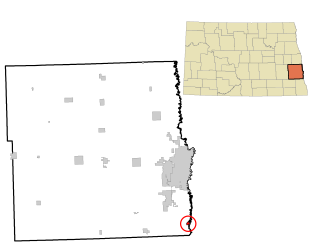
Oxbow is a city in Cass County, North Dakota, United States. The population was 381 at the 2020 census. It is an upscale bedroom community located 15 miles (24 km) south of Fargo. It was incorporated as a city October 25, 1988.

<span class="mw-page-title-main">South Prairie, Washington</span> Town in Washington, United States

South Prairie is a town in Pierce County, Washington, United States. The population was 373 at the 2020 census.

<span class="mw-page-title-main">South Greeley, Wyoming</span> Census-designated place in Wyoming, United States

South Greeley is a census-designated place (CDP) in Laramie County, Wyoming, United States. It is part of the Cheyenne, Wyoming Metropolitan Statistical Area. The population was 4,733 at the 2020 census. The population was 4,217 at the 2010 census.

<span class="mw-page-title-main">North Mankato, Minnesota</span> City in Minnesota, United States

North Mankato is a city in Nicollet and Blue Earth counties in the State of Minnesota. The population was 14,275 at the 2020 census.

North Roseau is an unorganized territory in Roseau County, Minnesota, United States. The population was 160 at the 2000 census.

Northwest Roseau is an unorganized territory in Roseau County, Minnesota, United States. The population was 18 at the 2000 census.

Southeast Roseau is an unorganized territory in Roseau County, Minnesota, United States. The population was 229 at the 2000 census.

References

  1. "2020 U.S. Gazetteer Files". United States Census Bureau. Retrieved July 24, 2022.
  2. "US Board on Geographic Names". United States Geological Survey. 2007-10-25. Retrieved 2008-01-31.
  3. "2010 Census Redistricting Data (Public Law 94-171) Summary File". American FactFinder. U.S. Census Bureau, 2010 Census. Retrieved 23 April 2011.[ dead link ]
  4. "Roseau County". Jim Forte Postal History. Retrieved 6 August 2015.
  5. "Lake of the Woods".
  6. Upham, Warren (1920). Minnesota Geographic Names: Their Origin and Historic Significance. Minnesota Historical Society. p.  473.
  7. "US Gazetteer files 2010". United States Census Bureau. Archived from the original on 2011-02-20. Retrieved 2012-11-13.
  8. United States Census Bureau. "Census of Population and Housing" . Retrieved September 11, 2013.
  9. "Annual Estimates of the Resident Population: April 1, 2010 to July 1, 2012". Archived from the original on October 19, 2013. Retrieved September 11, 2013.
  10. "U.S. Census website". United States Census Bureau . Retrieved 2012-11-13.

Coordinates: 48°48′13″N95°05′49″W / 48.80361°N 95.09694°W / 48.80361; -95.09694