Ros Tapestry Project

Last updated

The Ros Tapestry Project is a major community arts and history project centered on the town of New Ross in County Wexford, Ireland. The project is dedicated to producing a tapestry in fifteen panels which tells the story of the coming of the Normans to Ireland in the 12th century and the foundation of the port and town of New Ross at the beginning of the 13th century. Each tapestry panel is approximately four and a half feet deep (1.5m) by six feet (1.8m) wide and tells of a unique aspect of the epic story. Six panels were finished for an Exhibition in 2007 and a further nine panels are now (2020) completed.

Contents

History of the project

Beginning

The project began in May 1998 with an idea to make a tapestry telling the story of the coming of the Normans to Ireland in tapestry form and to hang this tapestry in the historic St. Mary's Church of Ireland Church in New Ross. The idea originated with the Rector of the Church, Reverend Paul Mooney, who then consulted with Alexis Bernstorff, an art historian and professional in the field of tapestry and fabric restoration. Over the summer of 1998, Dr. Mooney and Alexis Bernstorff consulted with local artist Ms. Reiltin Murphy to create a visualisation of how the tapestry could be best displayed in the Church of Ireland parish church. At that time the focus of the tapestry widened from the story of the Norman expansion into Ireland in the latter part of the 12th century to include the founding of the port and town of New Ross at the beginning of the 13th century. A provisional list of fifteen themes for tapestry panels was outlined, as well as the measurements for the panels to be hung from the gallery of the late Georgian, early 19th-century church. Countess Ann Griffin Bernstorff, professional artist and mother of Alexis Bernstorff, was approached to consider designing the tapestry and offered to paint the cartoons for the fifteen panels. Countess Bernstorff began with some experimental pieces in the Autumn of 1998 and a draft plan for the project was produced and circulated at that time.

Planning

In the spring of 1999, a small committee of people began to plan for the project in earnest, and New Ross lawyer Simon Kennedy freely gave of his time and services to draft articles of association for the project and to register the project as a company limited by guarantee without shares. This not-for-profit legal status helped pave the way for applications for grants and for the successful application for status for the project.

Painting

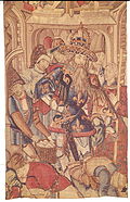
Meanwhile, following extensive historical research Countess Bernstorff painted the cartoon for the first tapestry panel which depicted the Hook Lighthouse in the Medieval era. This lighthouse is the oldest continually serving working lighthouse in Europe and was founded by monks in the early Middle Ages as Christianity came into southeast Ireland. This panel was given to a group of volunteer stitchers in Fethard-on-Sea in early 2000, as there is a policy to locate the creation each panel close to the historical location, and this panel was completed over the next three years. Alexis Bernstorff supervised the training of stitchers and the coordination of the production of the tapestry panel and served in this capacity on all tapestry panels.

Stitching

From 2000 to 2012, twelve panels were produced by the extraordinary commitment, skill and 'espirit de corp' of the voluntary stitchers. These panels are:

Over the last fourteen years 150 voluntary stitchers stitching on panels at various locations in County Wexford and at one location in County Kilkenny in Ireland. In many cases people have agreed to let a room of their house be used for up to four or more years as a location for the stitching of panels.

As of 2020, three additional panels have been completed. These are:

See also

Related Research Articles

<span class="mw-page-title-main">Lordship of Ireland</span> English-ruled territory in Ireland

The Lordship of Ireland, sometimes referred to retrospectively as Anglo-Norman Ireland, was the part of Ireland ruled by the King of England and controlled by loyal Anglo-Norman lords between 1177 and 1542. The lordship was created following the Anglo-Norman invasion of Ireland in 1169–1171. It was a papal fief, granted to the Plantagenet kings of England by the Holy See, via Laudabiliter. As the Lord of Ireland was also the King of England, he was represented locally by a governor, variously known as the Justiciar, Lieutenant, Lord Lieutenant or Lord Deputy.

<span class="mw-page-title-main">County Wexford</span> County in Ireland

County Wexford is a county in Ireland. It is in the province of Leinster and is part of the Southern Region. Named after the town of Wexford, it was based on the historic Gaelic territory of Hy Kinsella, whose capital was Ferns. Wexford County Council is the local authority for the county. The population of the county was 163,527 at the 2022 census.

<span class="mw-page-title-main">New Ross</span> Town in County Wexford, Ireland

New Ross is a town in southwest County Wexford, Ireland. It is located on the River Barrow, near the border with County Kilkenny, and is around 20 kilometres (12 mi) northeast of Waterford. In 2022 it had a population of 8,610 people, making it the fourth-largest town in the county.

<span class="mw-page-title-main">Fethard-on-Sea</span> Village in County Wexford, Ireland

Fethard-on-Sea or Fethard is a village in southwest County Wexford in Ireland. It lies on the R734 road on the eastern side of the Hook peninsula, between Waterford Harbour and Bannow Bay.

Clonroche is a village in County Wexford, Ireland. It is located approximately 15 km (9.3 mi) west of Enniscorthy and approximately 25 km (16 mi) east of New Ross, on the N30 national primary route.

<span class="mw-page-title-main">Osraige</span> Medieval southeastern Irish kingdom

Osraige or Osraighe, Osraí, anglicized as Ossory, was a medieval Irish kingdom comprising what is now County Kilkenny and western County Laois, corresponding to the Diocese of Ossory. The home of the Osraige people, it existed from around the first century until the Norman invasion of Ireland in the 12th century. It was ruled by the Dál Birn dynasty, whose medieval descendants assumed the surname Mac Giolla Phádraig.

<span class="mw-page-title-main">N30 road (Ireland)</span> Road in Ireland

The N30 road is a national primary road in Ireland. It connects the N25 road and M11 motorway, providing a link running east-northeast through County Wexford, between New Ross and Enniscorthy. This provides for a more direct national route between the two towns, as the N25 and N11 both run to Wexford town, eastwards from New Ross and southwards from Enniscorthy respectively.

<span class="mw-page-title-main">Jerpoint Abbey</span> Ruined Cistercian abbey in Kilkenny, Ireland

Jerpoint Abbey is a ruined Cistercian abbey, founded in the second half of the 12th century in County Kilkenny, Ireland. It is located 2.5 km south west of Thomastown on the R448 regional road. There is a visitor centre with an exhibition. It has been declared a national monument and has been in the care of the Office of Public Works since 1880.

<span class="mw-page-title-main">Aghaboe</span> Hamlet in County Laois, Ireland

Aghaboe is a small village in County Laois, Ireland. It is located on the R434 regional road in the rural hinterland west of the town of Abbeyleix.

<span class="mw-page-title-main">Mullinahone</span> Village in Munster, Ireland

Mullinahone is a village located in the barony of Slievardagh, County Tipperary in Ireland. It is also a parish in the Roman Catholic Archdiocese of Cashel and Emly. As of 2016, the village population was 499.

<span class="mw-page-title-main">Rosbercon</span> Village in County Wexford, Ireland

Rosbercon is a village in Ireland, on the opposite side of the River Barrow from New Ross, County Wexford. Although the village was originally in County Kilkenny, much of it is now in Wexford for administrative purposes. It had a population of 699 at the 2022 census.

Newbawn is a small village located in the southwest of County Wexford, in Ireland. It is 11 km south-east of New Ross, and 20 km west of Wexford town, and is on the R735 regional road about 3 km south of the N25 national primary road.

<span class="mw-page-title-main">St Canice's Cathedral</span> Church in County Kilkenny, Ireland

St Canice's Cathedral, also known as Kilkenny Cathedral, is a cathedral of the Church of Ireland in Kilkenny city, Ireland. It is in the ecclesiastical province of Dublin. Previously the cathedral of the Diocese of Ossory, it is now one of six cathedrals in the United Dioceses of Cashel and Ossory.

<span class="mw-page-title-main">History of Kilkenny</span>

The history of Kilkenny began with an early sixth-century ecclesiastical foundation, this relates to a church built in honour of St. Canice, now St. Canice's Cathedral and was a major monastic centre from at least the eighth century. The Annals of the Four Masters recorded the first reference Cill Chainnigh in 1085. Prehistoric activity has been recorded suggesting intermittent settlement activity in the area in the Mesolithic and Bronze Age. Information on the history of Kilkenny can be found from newspapers, photographs, letters, drawings, manuscripts and archaeology. Kilkenny is documented in manuscripts from the 13th century onwards and one of the most important of these is Liber Primus Kilkenniensis.

<span class="mw-page-title-main">Galmoy (barony)</span> Barony in County Kilkenny, Ireland

Galmoy is a barony in the north western part of County Kilkenny, Ireland. It is one of 12 baronies in County Kilkenny. The size of the barony is 162.7 square kilometres (62.8 sq mi). There are 12 civil parishes in Galmoy. While it is named after the village of Galmoy, today the chief town of the barony is Urlingford. Galmoy barony lies at the north-western corner of the county between Fassadinin to the east, and Crannagh to the south. It is surrounded on two sides by counties Tipperary to the west and Laois to the north. The M8 Dublin/Cork motorway bisects the barony. It is situated 121 kilometres (75 mi) from Dublin city and 131 kilometres (81 mi) from Cork city. Galmoy is currently administered by Kilkenny County Council. The barony was part of in the historic kingdom of Osraige (Ossory).

Clonmines is a civil parish and townland in the Bannow Bay area of County Wexford, Ireland, the site of "the finest example in Ireland of a deserted medieval borough". It is situated in the barony of Shelburne, southwest of Wellingtonbridge on the northwest shore of Bannow Bay. The parish of Clonmines contains the townland of the same name and the smaller townland of Arklow, with respective areas of 1,258 acres (509 ha) and 127 acres (51 ha).

<span class="mw-page-title-main">Callan (barony)</span> Barony in County Kilkenny, Ireland

The barony of Callan is a barony in the west of County Kilkenny, Ireland. The barony is 22.9 square kilometres (8.8 sq mi) in size. It is one of 12 baronies in County Kilkenny. Unusually for a barony, it contains only two civil parishes which together comprise 65 townlands. The chief town is Callan. The barony is bordered by the baronies of Shillelogher to the north and by Kells to the south. The N76 road bisects the barony. Notable features include Callan Motte and Callan Augustinian Friary.

<span class="mw-page-title-main">Knocktopher (barony)</span> Barony in County Kilkenny, Ireland

The barony of Knocktopher is a barony in the west of County Kilkenny, Ireland. The barony is 46,765 acres (189.25 km2) in size. There are 16 civil parishes made up of 125 townlands. It is one of 12 baronies in the county. The chief town is Mullinavat and it contains the settlements of Stonyford, Ballyhale, Hugginstown, Knocktopher, and Dunnamaggan. The M9 motorway bisects the barony.

<span class="mw-page-title-main">Shillelogher</span> Barony in County Kilkenny, Ireland

The barony of Shillelogher is a barony in the west of County Kilkenny, Ireland. The barony is 36,684 acres (148.45 km2) in size. It is one of 12 baronies in County Kilkenny. There are 19 civil parishes in Shillelogher, made up of 109 townlands. The chief town is Bennettsbridge. Shillelogher lies at the centre of the county, with the baronies of Crannagh and Kilkenny to the north (whose chief towns are Freshford and Kilkenny, and the barony of Gowran to the east. It is borders County Tipperary to the west. The N76 road bisects the barony. The river Nore flows through the barony. Danesfort Church is located in Shillelogher.

References

  1. "1. The Celts – An Island Fastness". Ros Tapestry. Retrieved 8 March 2020.
  2. "13. The Walling of Ros – Sixteen Guilds Protect Their Town". Ros Tapestry. Retrieved 8 March 2020.
  3. "5. Battles in the Kingdom of Ossory". Ros Tapestry. Retrieved 8 March 2020.