
Adams County is a county located in the U.S. state of Mississippi. As of the 2020 census, the population was 29,538. The county seat is Natchez. The county is the first to have been organized in the former Mississippi Territory. It is named for the second President of the United States, John Adams, who held that office when the county was organized in 1799. Adams County is part of the Natchez micropolitan area which consists of Adams County, Mississippi and Concordia Parish, Louisiana.

Lincoln County is a county located in the U.S. state of Mississippi. As of the 2020 census, the population was 34,907. Its county seat is Brookhaven. The county was created by the legislature on April 7, 1870, during the Reconstruction Era. It was formed from portions of Lawrence, Pike, Franklin, Copiah, and Amite counties. It was named for Abraham Lincoln, the 16th President of the United States. Lincoln County comprises the Brookhaven, MS Micropolitan Statistical Area, which is included in the Jackson–Vicksburg–Brookhaven Combined Statistical Area. The county is southwest of the state capital of Jackson.

Jefferson County is a county located in the U.S. state of Mississippi; its western border is formed by the Mississippi River. As of the 2020 census, the population was 7,260, making it the fourth-least populous county in Mississippi. Its first county seat was located at Old Greenville until 1825, which no longer exists, before moving to Fayette. The county is named for U.S. President Thomas Jefferson. One of the first of two counties organized in the Mississippi Territory in 1798 along with Adams County, it was first named Pickering County and included what would become Claiborne County. Originally developed as cotton plantations in the antebellum era, the rural county has struggled with a declining economy and reduced population since the mechanization of agriculture and urbanization of other areas. In 2020, its population of 7,260 was roughly one-third of the population peak in 1900. Within the United States, in 2009 rural Jefferson County had the highest percentage of African-Americans of any county. It was the fourth-poorest county in the nation.

Franklin County is a county located in the U.S. state of Mississippi. As of the 2020 census, the population was 7,675. Its county seat is Meadville. The county was formed on December 21, 1809, from portions of Adams County and named for Founding Father Benjamin Franklin. It is bisected by the Homochitto River, which runs diagonally through the county from northeast to southwest.

Amite County is a county located in the state of Mississippi on its southern border with Louisiana. As of the 2020 census, the population was 12,720. Its county seat is Liberty. The county is named after the Amite River, which runs through the county.

The Holly Springs National Forest (HSNF) was established by the United States Forest Service on June 15, 1936, during the tenure of United States Department of Agriculture Chief Forester Ferdinand A. Silcox. That same year, it was combined administratively with the Bienville, De Soto and Homochitto national forests, known collectively as "National Forests in Mississippi". The Holly Springs Ranger District controls 155,661 acres (243.2 sq mi) of Forest Service land, interspersed with 530,000 acres (828.1 sq mi) of privately owned properties, within the national forest's proclamation zone.
Homochitto National Forest is a U.S. National Forest in southwestern Mississippi comprising 191,839 acres (776.34 km2). In the mid-1930s, the Civilian Conservation Corps (CCC) began reforestation of the area and developing a system of roadways and recreational areas.

Mississippi Highway 33 is a state highway in southwestern Mississippi. It runs from north to south for 55.7 miles (89.6 km) and serves the counties of Jefferson, Franklin, Amite, and Wilkinson.
Doloroso is an unincorporated community in Wilkinson County, Mississippi, United States near the county seat Woodville and the Homochitto National Forest. The community rests on U.S. Route 61.
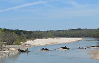
The Homochitto River is a river in the U.S. State of Mississippi. It flows from its source in southwest Mississippi for about 90 miles (145 km) west and south, emptying into the Mississippi River between Natchez and Woodville.
St. Catherine Creek National Wildlife Refuge was established in January 1990 to preserve, improve and create habitat for waterfowl. Intensive management programs on the St. Catherine's Creek refuge provide excellent winter habitat and resting areas for waterfowl in the Lower Mississippi River Valley.

The northern studfish is among the largest of the killifish and is native to the southcentral United States.
Little Springs is an unincorporated community in Franklin County, Mississippi.
Homochitto is an unincorporated community in Amite County, Mississippi, United States.

Homochitto was an 800-acre (320 ha) plantation located directly on the Mississippi River in Issaquena County, Mississippi, United States. According to one source, Homochitto is a Choctaw name likely meaning "big red", and was earlier applied to the Homochitto River in Mississippi.
Possum Corner is an unincorporated community in Wilkinson County, Mississippi, United States.
Bewelcome is an unincorporated community in Amite County, Mississippi, United States.

Second Creek is a waterway in the southern section of Adams County, Mississippi, United States. Second Creek is tributary to the Homochitto River. It enters the Homochitto near U.S. Route 61 bridge at Doloroso.
Sandy Creek is a right-bank tributary of the Homochitto River in Adams County, Mississippi, United States. Sandy Creek was one of the first places where white settlers and their black slaves set up farming in the colonial-era Natchez District. The Sandy Creek Wildlife Management Area, part of the Homochitto National Forest, is believed to host a population of Louisiana black bear.

