
Dartmoor is an upland area in southern Devon, England. The moorland and surrounding land has been protected by National Park status since 1951. Dartmoor National Park covers 954 km2 (368 sq mi).

A bog or bogland is a wetland that accumulates peat as a deposit of dead plant materials – often mosses, typically sphagnum moss. It is one of the four main types of wetlands. Other names for bogs include mire, mosses, quagmire, and muskeg; alkaline mires are called fens. A baygall is another type of bog found in the forest of the Gulf Coast states in the United States. They are often covered in heath or heather shrubs rooted in the sphagnum moss and peat. The gradual accumulation of decayed plant material in a bog functions as a carbon sink.

Moorland or moor is a type of habitat found in upland areas in temperate grasslands, savannas, and shrublands and montane grasslands and shrublands biomes, characterised by low-growing vegetation on acidic soils. Moorland, nowadays, generally means uncultivated hill land, but also includes low-lying wetlands. It is closely related to heath, although experts disagree on what precisely distinguishes these types of vegetation. Generally, moor refers to highland and high rainfall zones, whereas heath refers to lowland zones which are more likely to be the result of human activity. Moorland habitats mostly occur in tropical Africa, northern and western Europe, and neotropical South America. Most of the world's moorlands are diverse ecosystems. In the extensive moorlands of the tropics, biodiversity can be extremely high. Moorland also bears a relationship to tundra, appearing as the tundra and the natural tree zone. The boundary between tundra and moorland constantly shifts with climatic change.

The Southern Uplands are the southernmost and least populous of mainland Scotland's three major geographic areas. The term is used both to describe the geographical region and to collectively denote the various ranges of hills and mountains within this region. An overwhelmingly rural and agricultural region, the Southern Uplands are partly forested and contain many areas of open moorland - the hill names in the area are congruent with these characteristics.

The Galloway Hills are part of the Southern Uplands of Scotland, and form the northern boundary of western Galloway. They lie within the bounds of the Galloway Forest Park, an area of some 300 square miles (800 km2) of largely uninhabited wild land, managed by Forestry and Land Scotland. The unusual place names reflect a mixture of the Old Norse and Scottish Gaelic languages and hint at the range of influences which have acted on society within the area over the centuries.

Cairnsmore of Fleet is an isolated mountain in the Southern Uplands of Scotland. The mountain forms an unafforested granite massif, whose highest point is about 10 kilometres (6.2 mi) east of Newton Stewart. It is the highest of the "Solway Hills" sub-range, and the southernmost of Scotland's 219 Grahams, thus making it, or rather its subsidiary top, Knee of Cairnsmore, the most southerly mountain in Scotland. The view to the south takes in the Cree Estuary and Wigtown Bay, and extends as far as the Lake District, the Isle of Man and Snowdonia. The highest summits of the Galloway Hills can be seen to the north, and Ireland is in the view to the west.

Cors Caron is a raised bog in Ceredigion, Wales. Cors is the Welsh word for "bog". Cors Caron covers an area of approximately 349 hectares. Cors Caron represents the most intact surviving example of a raised bog landscape in the United Kingdom. About 44 different species groups inhabit the area including various land and aquatic plants, fish, insects, crustaceans, lichen, fungi, terrestrial mammals and birds.

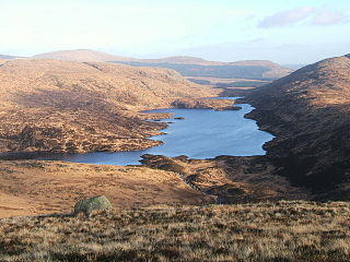
Loch Enoch is a multi-basin freshwater loch in Galloway, to the east of Merrick and south of Mullwharchar. The loch is situated in a granite basin and has several small islands and some beaches on its shore. The sharp granite sand of these beaches was collected and sold for sharpening knives and scythes. The catchment area's vegetation is mainly Purple Moor Grass and Heather.
Loch Valley is a loch in Galloway Forest Park to the east of Buchan Hill, north of the Rig of the Jarkness and southwest of Craignaw. It drains via Gairland Burn down to Loch Trool.

Raised bogs, also called ombrotrophic bogs, are acidic, wet habitats that are poor in mineral salts and are home to flora and fauna that can cope with such extreme conditions. Raised bogs, unlike fens, are exclusively fed by precipitation (ombrotrophy) and from mineral salts introduced from the air. They thus represent a special type of bog, hydrologically, ecologically and in terms of their development history, in which the growth of peat mosses over centuries or millennia plays a decisive role. They also differ in character from blanket bogs which are much thinner and occur in wetter, cloudier climatic zones.
Under UNESCO’s Man and the Biosphere Programme, there are 308 biosphere reserves recognized as part of the World Network of Biosphere Reserves in Europe and North America. These are distributed across 41 countries in the region.
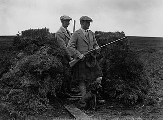
Driven grouse shooting is the hunting of the red grouse, a field sport of the United Kingdom. The grouse-shooting season extends from 12 August, often called the "Glorious Twelfth", to 10 December each year. Large numbers of grouse are driven to fly over people with shotguns. Driven grouse shooting first appeared around 1850 and became popular in the later Victorian era as a fashionable sport for the wealthy. The expanding rail network allowed relatively easy access into the remote upland areas of Britain for the first time and driven grouse shooting developed in tandem with this by providing shooting in a convenient and reliable form. Large numbers of birds are driven over a fixed position providing a regular supply of fast moving targets without the need to seek out the birds. The development of the breech-loading shotgun was also an essential ingredient in the development of the practice as it allowed more rapid reloading in the field matching the availability of target birds.

Potamogeton polygonifolius or bog pondweed, is an aquatic plant. It is found in shallow, nutrient-poor, usually acid standing or running water, bogs, fens and occasionally ditches.
Lune Forest is a Site of Special Scientific Interest covering an extensive area of moorland in the Teesdale district of west Durham, England. In the north, where it adjoins the Upper Teesdale and Appleby Fells SSSIs, it extends from Mickle Fell eastward almost as far as Harter Fell, above the hamlet of Thringarth. Its southern limit is marked by the River Balder, upstream from Balderhead Reservoir, where it shares a boundary with Cotherstone Moor SSSI to the south. Grains o' th' Beck Meadows and Close House Mine SSSIs are entirely surrounded by Lune Forest, but do not form part of it.
The Dyfi Biosphere is situated at the coast of south-central Wales in the estuary of the River Dyfi, and is a biosphere reserve representative of salt marshes and estuarine systems in the west of the United Kingdom. The estuary forms one of the most important wildfowl and shorebird centres in Wales and also comprises a Ramsar site.

Situated in south-west Scotland, the Silver Flowe-Merrick Kells biosphere reserve is composed of two separate sites.

Bewick and Beanley Moors is the name given to a Site of Special Scientific Interest (SSSI) in north Northumberland, in the north-east of England. The moors are asserted to be of national importance by Natural England for the extent, quality and diversity of upland types including heaths, fens, wet grassland, flushes, mires and blanket bogs, together creating an extensive mosaic habitat supporting an exceptional community of amphibians. The moors are important, too, for their relict juniper woodland and scrub.
The Dungeon Hills are a range of hills in the Galloway Hills range, part of the Southern Uplands of Scotland. The central of three parallel ridges, they are neighboured by the Range of the Awful Hand to the west and the Rhinns of Kells to the east. The range is also perpendicular to the Minnigaff Hills range, immediately south. In total, these four ranges are part of the Galloway Forest Park.

The Rhinns of Kells are a range of hills in the Galloway Hills range, part of the Southern Uplands of Scotland. The most easterly of three parallel ridges, they are neighboured to the west by the Range of the Awful Hand and the Dungeon Hills. The eastern portion of the Minnigaff Hills range lies immediately southwest of the range. In total, these four ranges are part of the Galloway Forest Park. The ridge is located entirely within Dumfries and Galloway, with the base of the western flanks being a northwestern boundary of the county.

