
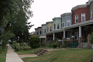
Charles Village is a neighborhood located in the north-central area of Baltimore, Maryland, USA. It is a diverse, eclectic, international, largely middle-class area with many single-family homes that is in proximity to many of Baltimore's cultural amenities. Nearby are the Baltimore Museum of Art, The Homewood campus of The Johns Hopkins University, Olmstead's Wyman Park, and the weekly Waverly Farmers Market, and the arts district, Station North. Homes are exemplary Baltimore brick and stone row houses, many dating from the 1890s. Running from downtown north is the historic boulevard, Charles Street, where Baltimore's Easter Promenade once took place.

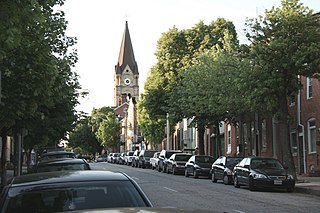
Bolton Hill is a neighborhood in Baltimore, Maryland, with 20 blocks of mostly preserved buildings from the late 19th century. It is listed on the National Register of Historic Places, preserved as a Baltimore City Historic District, and included within the boundaries of Baltimore National Heritage Area. The neighborhood is bounded by North Avenue, Mount Royal Avenue, Cathedral Street, Dolphin Street, and Eutaw Place. Bolton Hill is a largely residential neighborhood with three-story row houses with red brick, white marble steps, and high ceilings. There are also larger more ornate originally single-family houses, many houses of worship, parks, monuments, and a few large apartment buildings. Many significant residents have lived in the neighborhood, including F. Scott Fitzgerald, Woodrow Wilson, the Cone sisters, and Florence Rena Sabin.

Reservoir Hill, also known as Whitelock, is a neighborhood in the city of Baltimore, Maryland, United States. It is located south of Druid Hill Park, north of Bolton Hill, east of Penn-North, and west of Jones Falls. It is bounded by Druid Park Lake Drive, the Jones Falls Expressway, North Avenue, and McCulloh Street. It is contained in the 21217 ZIP code.

Butchers Hill is a neighborhood in Southeast Baltimore, Maryland, United States. It is north of Fells Point, east of Washington Hill, and northwest of Patterson Park. It is south of Fayette Street, west of Patterson Park Avenue, north of Pratt Street, and east of Washington Street. It is in the 21231 zip code.

Union Square is a neighborhood located in the Sowebo area of Baltimore. It dates to the 1830s and includes a historic district of houses and commerce buildings.

Ridgely's Delight is an historic residential neighborhood in Baltimore, Maryland, United States. Its borders are formed by Russell and Greene Streets to the east, West Pratt Street to the north, and Martin Luther King Jr. Boulevard from the western to southern tips. It is adjacent to the University of Maryland, Baltimore, Oriole Park at Camden Yards, and M&T Bank Stadium. It is situated a short walk from MARC Train and the Light Rail's Camden Station, which has made it a popular residence of Washington, D.C. and suburban Baltimore commuters. It is within a 5-minute walk of both Oriole Park at Camden Yards and M&T Bank Stadium and a 10-minute walk from Baltimore's historic Inner Harbor.

Woodberry is a neighborhood located in the north-central area of Baltimore, Maryland, USA. A largely residential, middle-class area, Woodberry is a historic community bordered on the north by Cold Spring Lane, on the south by Druid Hill Park, on the west by Greenspring Avenue, and on the east by the Jones Falls Expressway and the Jones Falls. Woodberry is located within Postal Zip code 21211.

Ednor Gardens-Lakeside is a large community in northeast Baltimore, Maryland. It is bounded by 33rd Street to the south, Hillen Road to the east, Ellerslie Avenue to the west, and Argonne Drive, The Alameda, Loch Raven Boulevard, and Roundhill Road to the north. Ednor Gardens was part of a large planned community that was built out from the 1920s through the 1950s by Edward Gallagher, one of Baltimore's most prolific homebuilders at the time. It is notable among its neighbors for the quality of the homes and extensive landscaping. Until it was torn down in 2002, Memorial Stadium was located in Ednor Gardens-Lakeside.

Mayfield is a small community in northeast Baltimore, Maryland. It is bounded by Erdman Avenue on the south, Chesterfield Avenue on the north, Crossland Avenue on the east and Lake Montebello on the north and west. Homeowners belong to the Mayfield Improvement Association.
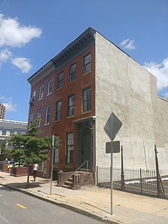
The Henry AugustRowland House is a historic row house at 915 Cathedral Street in Baltimore, Maryland. Built in the 1880s, this nondescript row house is historically important as the home of physicist Henry Augustus Rowland from 1889-90 until his death in 1901. It was listed on the National Register of Historic Places and declared a National Historic Landmark in 1975.
Upper Fells Point, also known as "Fells Prospect," is a neighborhood of Baltimore, Maryland, United States. Located north of Fells Point, originally the neighborhood was home to Baltimore's dock workers. By the 1880s canneries and factories provided employment to new immigrants, including Irish, Italians and Poles. In the early 1900s these new Americans were joined by Jews, Lithuanians and Greeks. Today its tidy brick rowhouses and tree-lined streets are home to both old-timers and young urban professionals. It is also the heart of Baltimore's growing Latino community and is sometimes called "Spanish Town". Although most Hispanics in the neighborhood are Mexicans, there are significant populations of Salvadorans, Puerto Ricans, Hondurans, Dominicans, Guatemalans, Colombians, and Cubans, as well as many others.
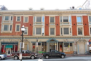
Brown's Arcade is a historic retail and office building located at Baltimore, Maryland, United States. It consists of four early 19th century brick rowhouses. Architect Henry F. Brauns redesigned a row of four, three story buildings in 1904 into the original Brown's Arcade, with the application of Colonial Revival details over the original Federal-style façade. It was converted to a series of small shops; bordering a straight central walkway with offices above. The rear courtyard contains two-story brick structures with shed roofs and a two-story Renaissance Revival style structure.

Douglass Place is a group of historic rowhouses located at Baltimore, Maryland, United States. Built in 1892, it represents typical "alley houses" of the period in Baltimore, two narrow bays wide, two stories high over a cellar, with shed roofs pitched to the rear. Italianate influence is reflected in their segmental-arched window and door openings, and in the simple molded sheet metal cornices which crown the buildings. Frederick Douglass (1818-1895) constructed the five buildings as rental housing for blacks in the Fells Point area of Baltimore, where he had resided from the 1820s to 1838. The site was the location of the Dallas Street Station Methodist Episcopal Church, which he had attended while living in the area.

South Central Avenue Historic District is a national historic district in Baltimore, Maryland, United States. It contains brick two- and three-story industrial and residential buildings reflecting over 150 years of utilitarian adaptation of buildings and space. The district includes early 19th century rowhouses, late 19th century and early 20th century manufacturing and warehouse buildings, gas stations, stables, car barns, commercial/residential buildings, and corner stores. Several larger buildings are the Bagby Furniture Company Building, the Strauss Malt House, and the Alameda School. Many rowhouses have been covered with formstone.

The buildings at 1601–1830 St. Paul Street and 12–20 E. Lafayette Street form a national historic district in Baltimore, Maryland, United States. They are a distinctive collection of 76 residential rowhouses in north central Baltimore, most of which were constructed between 1876 and 1906.

Oakenshawe Historic District is a national historic district in Baltimore, Maryland, United States. It comprises 334 buildings which reflect the neighborhood's development during the period 1890 to about 1926. The neighborhood evolved in two stages on the 19th century Wilson estate. The first phase of growth is represented by frame houses dating from 1890 to about 1910 reflecting vernacular interpretations of the Victorian Gothic and Italianate styles. The second stage of development began in the World War I era, when several developers transformed the property by constructing a neighborhood of brick "daylight" rowhouses in revival styles popular at the time.
Franklin Square Historic District is a national historic district in Baltimore, Maryland, United States. It is a 19th-century rowhouse neighborhood developed along a strict grid street pattern. A one square block, two and a half acre public park, Franklin Square, is a focal point for the area and the most elaborate rowhousing surrounds the square. The district contains approximately 1,300 buildings of which approximately 1,250 contribute to the significance of the historic district.

Baltimore East/South Clifton Park Historic District is a national historic district in Baltimore, Maryland, United States. It is primarily an urban residential area organized in a gridiron pattern. It comprises approximately 110 whole and partial blocks that formed the historic northeast corner of the City of Baltimore prior to 1888. While rowhouses dominate the urban area, the historic district also contains other property types which contribute to its character including brewing, meat packing, cigar manufacturing, printing, and a tobacco warehouse. The Baltimore Cemetery completes the historic district.
Remington is a neighborhood in northern Baltimore bordered to the north by Hampden, Wyman Park, and Johns Hopkins University and to the east by Charles Village. The southernmost boundary is North Avenue and the long southwestern boundary is formed by Falls Road in the I-83 corridor. The neighborhood is split between two Baltimore City Council Districts.
The Edmondson Avenue Historic District encompasses several neighborhoods on the west side of Baltimore, Maryland. The area was developed primarily between 1900 and 1940, radiating from the streetcar line that ran along Edmondson Avenue, an east–west thoroughfare. It includes significant portions of the Evergreen Lawn, Bridgeview/Greenlawn, Rosemont, and Midtown-Edmondson neighborhoods, including hundreds of buildings, many of them residential rowhouses. Although initially populated by European-Americans, the neighborhood population became predominantly middle class African-American in the year after World War II, and became a center of civil rights activism and community organizing. The Red-Light District of Balitimore is also in close proximity to the district with houses in the area contributing to the cause.


