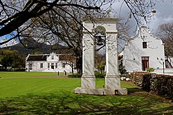
Stellenbosch is a town in the Western Cape province of South Africa, situated about 50 kilometres east of Cape Town, along the banks of the Eerste River at the foot of the Stellenbosch Mountain. The town became known as the City of Oaks or Eikestad in Afrikaans and Dutch due to the large number of oak trees that were planted by its founder, Simon van der Stel, to grace the streets and homesteads.

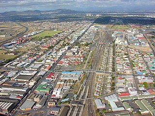
Bellville is a town and former independent city that is now incorporated into the City of Cape Town Metropolitan Municipality in the Western Cape province of South Africa. The town is an industrial and commercial node, a university town, and a major transportation hub within the Greater Cape Town metropolitan area.

Stellenbosch University (SU) (Afrikaans: Universiteit Stellenbosch, Xhosa: iYunivesithi yaseStellenbosch) is a public research university situated in Stellenbosch, a town in the Western Cape province of South Africa. Stellenbosch is the oldest university in South Africa and the oldest extant university in Sub-Saharan Africa, which received full university status in 1918. Stellenbosch University designed and manufactured Africa's first microsatellite, SUNSAT, launched in 1999.

Brackenfell is a town in the Western Cape province of South Africa and a northern suburb of Cape Town, situated about 30 km north-east of the city.

Tygerberg is a district in the northern suburbs of Cape Town in South Africa. It is also the name of the range of hills in the area. The main Tygerberg farms were Pampoenkraal, Stellenburgh, Evertsdal, De Grendel, Lebenstijn, Blommensteijn, Door de Kraal, Vissershok and Clara Anna Fontein. It also contains the Tygerberg Nature Reserve.
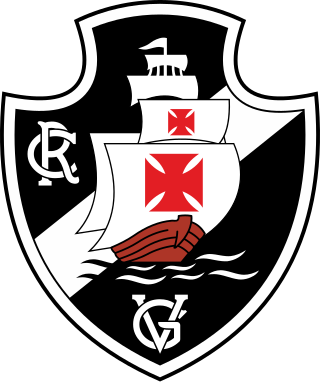
Vasco da Gama was a South African football club based in the Parow suburb of the city of Cape Town that played in the National First Division. Coming from the lower ranks, the club had its roots entrenched in the local Portuguese South African community, and adopted its name, crest and team colours from the Brazilian club Club de Regatas Vasco da Gama.

St. George's Grammar School is a private co-educational day school located in Mowbray, a suburb of Cape Town, South Africa. It was historically the cathedral school attached to St. George's Cathedral, having been founded in 1848 by Robert Gray, the first Anglican Bishop of Cape Town. St. George's claims to be the oldest independent school in South Africa.
Eerste River is a town in the Western Cape, South Africa and a suburb of the City of Cape Town. It forms part of the Eastern Suburbs zone of the city situated behind the Stellenbosch/Vlaeberg Hills on the eastern outskirts of the city..

Kayamandi is a suburb of Stellenbosch in the Western Cape province of South Africa located off route R304. Kayamandi is one of the developing townships situated in Stellenbosch.
Maitland is a suburb of Cape Town, South Africa.
Faure is a hamlet some 16 km south-west of Stellenbosch and 13 km north-west of Strand. Administratively it is a suburb of the City of Cape Town, and is in the Helderberg region. Nearby is the kramat or tomb of Sheik Yusuf (1626-1699), an Islamic expatriate priest. Faure is a common surname; it is uncertain after whom this place was named. It may have been named after Pieter Faure, the name of South Africa's first trawler which arrived in Table Bay in 1897.
James Mortimer Maynard was an influential money-lender and businessman of the Cape Colony, and a founding Member of the Cape Legislative Assembly, where he was elected to represent the Cape Division constituency.

Stellenberg is a suburb in Bellville, Western Cape South Africa.
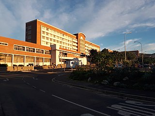
Karl Bremer Hospital is a hospital, situated in Bellville, Western Cape, South Africa. It was opened in 1956 with one ward. It was originally an academic hospital for medical students of Stellenbosch University and was utilised for this purpose until 1976, after which it changed to a hospital catering for private patients.
Rozendaal is a Dutch toponymic surname. Literally meaning "rose valley", the name may indicate an origin in the city of Roosendaal, North Brabant or the towns Rozendaal (Gelderland), Rozendaal, or Rozendaal. Both the surname and these town names may also have evolved from Roesendael, meaning "reed valley". Among variant spellings are Roosendaal, Roosendael, Roozendaal, and Rosendaal, each pronounced in Dutch. People with these surnames include:
The M10 is a metropolitan route in the City of Cape Town Metropolitan Municipality, South Africa. It connects the town of Bellville with Philippi on the Cape Flats.
The M12 is a long metropolitan route in the City of Cape Town, South Africa. It connects Burgundy Estate with Stellenbosch via Parow, Elsie's River and Kuils River.

Sylvius Gerard Marie "Boy" Rozendal was an Curaçao politician and journalist. He served as Prime Minister of the Netherlands Antilles from 1971 until 1975, Minister of Finance and Deputy Prime Minister from 1969 until 1971, and Minister Plenipotentiary of the Netherlands Antilles from 1971 until 1975.