Tulbagh

Last updated

Tulbagh
Tulbagh Collage.png
South Africa Western Cape location map.svg
Red pog.svg
Tulbagh
South Africa adm location map.svg
Red pog.svg
Tulbagh
Coordinates: 33°17′6″S19°8′16″E / 33.28500°S 19.13778°E / -33.28500; 19.13778
Country South Africa
Province Western Cape
District Cape Winelands
Municipality Witzenberg
Established1795 [1]
Named for Ryk Tulbagh
Area
[2]
  Total3.81 km2 (1.47 sq mi)
Elevation
180 m (590 ft)
Population
 (2011) [2]
  Total8,969
  Density2,400/km2 (6,100/sq mi)
Racial makeup (2011)
[2]
   Black African 22.7%
   Coloured 69.3%
   Indian/Asian 0.2%
   White 6.9%
  Other0.8%
First languages (2011)
[2]
   Afrikaans 74.4%
   Xhosa 18.3%
   English 3.6%
   Sotho 2.0%
  Other1.7%
Time zone UTC+2 (SAST)
Postal code (street)
6820
PO box
6820
Area code 023

Tulbagh, previously named Roodezand, later named after Dutch Cape Colony Governor Ryk Tulbagh, is a town located in the "Land van Waveren" mountain basin (also known as the Tulbagh basin), [3] in the Winelands of the Western Cape, South Africa. The basin is fringed on three sides by mountains, and is drained by the Klein Berg River and its tributaries. The nearest towns are Ons Rust and Gouda beyond the Nuwekloof Pass, Wolseley some 15 kilometres (9.3 mi) to the south inside the basin, and Ceres and Prince Alfred Hamlet beyond Michell's Pass in the Warm Bokkeveld.

Contents

History

The basin has been inhabited for thousands of years by indigenous Bushmen and Khoi-San peoples. It was about 300 years ago when, after a land grant by the Dutch Colonial Government to a more or less equal number of Dutch and Huguenot settlers to settle the area, that the town of Tulbagh was founded. The region was named "Land van Waveren" in 1699 by Willem Adriaan van der Stel in honour of the Oetgens van Waveren family, from which his mother was descended. Before this date, but also subsequent to it, the region had also been known as Roodezand ("red sand"). The region corresponds to the present Tulbagh district, named after Governor Ryk Tulbagh. The town developed slowly and over time and in the period many notable examples of Cape Dutch architecture, Victorian and Edwardian houses and other buildings such as the Oude Kerk (1743) and the Oude Drosdy (the original colonial Magistrate's complex) were built.

1969 earthquake

In September 1969 the Boland area was hit by an earthquake that caused considerable damage to the town of Tulbagh. Many of the Church Street buildings were destroyed. The extent of the damage was aptly described by the Journal Bulletin of the Simon van der Stel Foundation in 1973: "A street that somehow captured the essential spirit of a unique culture looked as if it was in the throes of a nightmare: many fine gables had either tumbled or were totally destroyed, whole sections of many houses had collapsed, most of the soft brick walls had burst open in wide cracks, plaster had been torn by off in large sheets, rafters and roofs had caved in. Everything appeared to be in total and irreparable ruin." [4]

After the disaster in Church Street, extensive projects of restoration began with the National Committee for the Restoration of Historic Buildings in Tulbagh and its Environment. [4] Because of this work Tulbagh now contains possibly the largest number of Cape-Dutch, Edwardian and Victorian provincial heritage sites in one street in South Africa, and remains a major tourist attraction of the town to the present day. The work started by the committee has been continued to the present day by various residents of Tulbagh, but also significantly by the Tulbagh Valley Heritage Foundation, which aims to restore and maintain "all structures older than 60 years, the cultural landscape and undeveloped properties connected to the historical structures above". [5]

Church Street, Tulbagh, restored houses Tulbagh, Church Street, Restored Houses 1.png
Church Street, Tulbagh, restored houses
Church Street, Tulbagh, some more restored houses Tulbagh, Church Street, Restored Houses 2.png
Church Street, Tulbagh, some more restored houses

Geography

The bowl is surrounded by the Obiqua Mountains to the west, Groot Winterhoek Mountain to the north and the Witzenberg Mountains to the east, with peaks that rise to over 1,500 metres (4,900 ft). The basin experiences a type of Mediterranean climate. The southern side is open to cooling south-east winds during the hot summer months. Accordingly, Tulbagh enjoys some of the most diverse and attractive conditions for viticulture in the Cape, and the differences in terroir available to wine makers allow for a wide diversity of distinctive wines.

The Groot Winterhoek Mountains are part of the Cape Fold Belt. They rise to a maximum height of 2,077 metres (6,814 ft) just north of the town of Tulbagh as Groot Winterhoek peak. The Groot Winterhoek Wilderness Area, operated by CapeNature, comprises a conservation area of 30,608 ha.[ citation needed ]

Flora and Fauna

Many animals, such as baboons, bat-eared foxes, lynxes, and smaller species of antelope, live in parts of the valley, and it is known that leopards still occur in the mountains [ citation needed ]. Baboons are a common sight on the pass. The Witzenberg Valley is home to a wide variety of birds, including the Cape sugarbird and Verreaux's eagle.[ citation needed ]

The most conspicuous components of the flora are evergreen sclerophyllous plants, many with ericoid leaves and gracile habit, as opposed to timber forest. Several plant families are conspicuous in fynbos; the Proteaceae are prominent, with genera such as Protea , Leucospermum (the "pincushions"), and Leucadendron (the silver tree and "cone bushes"). Proteas are represented by many species and are prominent in the landscape, generally with large striking flowers, many of which are pollinated by birds, and others by small mammals.[ citation needed ]

Tulbagh today

Events

Tulbagh hosts various events every year. In June, the village Christmas in Winter; in September the Tulbagh Spring Arts Festival showcases a variety of visual and performing arts; and the annual Tulbagh Horse & Wildflower Show. Tulbagh has also previously hosted the Absa Cape Epic mountain bike stage race.[ citation needed ]

Wine production

The historic vineyard Montpellier near Tulbagh Montpellier-2.jpg
The historic vineyard Montpellier near Tulbagh
Red wine maturing in oak barrels Wynvate.jpg
Red wine maturing in oak barrels

Wine has been produced for many years in the basin on a commercial scale, but only recently have large advances been made. There are now numerous wine estates in and around the town. The importance of this industry for the vicinity is substantial, so much so that many of the producers are now part of the Tulbagh Wine Route and this is attracting increasing numbers of tourists to Tulbagh who are eager to sample the wines produced by the members. Many new vineyards have been planted and more private cellars are either being planned or built to cope with the expected production volumes of quality wines.

Tulbagh also has two nearby schools: one named Waveren Hoërskool (Waveren Highschool) and another named Tulbagh Hoër (Tulbagh High).

See also

Related Research Articles

<span class="mw-page-title-main">Witzenberg Local Municipality</span> Local municipality in Western Cape, South Africa

Witzenberg Municipality is a local municipality located within the Cape Winelands District Municipality, in the Western Cape province of South Africa. As of 2011 it had a population of 115,946.

<span class="mw-page-title-main">Berg River</span> River in the Western Cape, South Africa

The Berg River is a river located just north of Cape Town in the Western Cape Province of South Africa. It is approximately 294 km (183 mi) long with a catchment area of 7,715 km2 (2979 mi2) and debouches into the Atlantic Ocean. About 65% of the Berg River area is under agriculture. The major towns in the Berg River area are Velddrif and Laaiplek near the coast, Piketberg, Hopefield, Moorreesburg and Darling further inland.

<span class="mw-page-title-main">Simon van der Stel</span> Dutch colonial administrator

Simon van der Stel was the first Governor of the Dutch Cape Colony (1691), the settlement at the Cape of Good Hope. He was interested in botany, establishing vineyards Groot and Klein Constantia, and producing a famous dessert wine. He is considered one of the founders of South African viticulture.

<span class="mw-page-title-main">Somerset West</span> Town in the Western Cape, South Africa

Somerset West is a town in the Western Cape, South Africa. Organisationally and administratively it is included in the City of Cape Town metropolitan municipality as a suburb of the Helderberg region . The vehicle registration code for Somerset West is CFM and the post code is 7130 for street addresses, and 7129 for post office boxes.

<span class="mw-page-title-main">Constantia, Cape Town</span> Place in Western Cape, South Africa

Constantia is an affluent suburb of Cape Town, South Africa, situated about 15 kilometres south of the centre of Cape Town. It is considered to be one of the most prestigious suburbs in South Africa. The Constantia Valley lies to the east of and at the foot of the Constantiaberg mountain. Constantia Nek is a low pass linking to Hout Bay in the west.

<span class="mw-page-title-main">Groot Constantia</span> Colonial manor house and wine estate in Cape Town, South Africa

Groot Constantia is the oldest wine estate in South Africa and provincial heritage site in the suburb of Constantia in Cape Town, South Africa.

<span class="mw-page-title-main">Helderberg</span> Region of the City of Cape Town, South Africa

Helderberg refers to a planning district of the City of Cape Town metropolitan municipality, the mountain after which it is named, a wine-producing area in the Western Cape province of South Africa, or a small census area in Somerset West.

<span class="mw-page-title-main">Willem Adriaan van der Stel</span>

Willem Adriaan van der Stel was an Extraordinary Councillor of the Dutch East Indies, and Governor of the Cape Colony, a way station for the Dutch East India Company (VOC), from 23 January 1699 to 1707. He was dismissed after a revolt and was exiled to the Netherlands.

<span class="mw-page-title-main">Drakenstein</span>

The Drakenstein mountain opposite Simonsberg Mountain named after ex military man and Colonial administrator of the Dutch East India Company Hendrik Adriaan van Rheede tot Drakenstein is part of the Cape Fold Belt and are in the Western Cape province of South Africa.

<span class="mw-page-title-main">Groot Winterhoek</span> Mountain range in the Western Cape region of South Africa

The Groot Winterhoek mountains are located in the Western Cape province of South Africa and are part of the Cape Fold Belt comprising a watershed area of 552,606 hectares. They rise to a maximum height of 2077 m just north of the town of Tulbagh as Groot Winterhoek peak. The mountains are predominantly made up of Table Mountain sandstone. Up to 83% of the range is still classified as being in a natural state and up to 72% of the range is protected. The towns of Saron and Porterville are located at the foot the mountain range's western side.

<i>Protea neriifolia</i> Species of flowering plant in the family Proteaceae

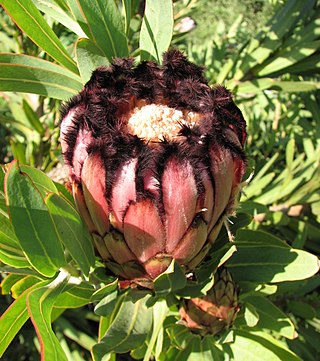
Protea neriifolia, also known as the narrow-leaf sugarbush, oleander-leaved sugarbush, blue sugarbush, or the oleanderleaf protea, is a flowering plant in the genus Protea, which is endemic to South Africa.

<span class="mw-page-title-main">Ryk Tulbagh</span> Dutch Governor of the Cape Colony

Ryk Tulbagh was Governor of the Dutch Cape Colony from 27 February 1751 to 11 August 1771 under the Dutch East India Company (VOC).

<span class="mw-page-title-main">Jonkershoek Nature Reserve</span> Nature reserve in the Western Cape of South Africa

Jonkershoek Nature Reserve is a CapeNature nature reserve located approximately 10 km (6 mi) south-east of the town of Stellenbosch in the Western Cape province of South Africa. It covers an area of approximately 11,000 hectares.

<span class="mw-page-title-main">Assegaaibosch Nature Reserve</span> Historic estate in the Western Cape, South Africa

Assegaaibosch Nature Reserve is a historic estate and currently a CapeNature nature reserve and World Heritage Site situated in the Jonkershoek Valley near Stellenbosch in the Western Cape province of South Africa. The historic estate was established by Dirk Coetsee, the progenitor of the Coetsee family in South Africa.

<span class="mw-page-title-main">Wolseley, South Africa</span> Place in Western Cape, South Africa

Wolseley is a small town in the upper Breede River Valley region of the Western Cape province of South Africa. In the 2011 Census it had a population of 1,528 people. It is located 90 kilometres (60 mi) northeast of Cape Town, in the Land van Waveren valley between the Waterval Mountains to the west and the Witzenberg Mountains to the east.

<span class="mw-page-title-main">Coetsenburg</span> Historic wine estate in South Africa

Coetsenburg is an historic wine estate and one of the oldest estates in South Africa, established in 1682. It is located at the foot of the Stellenbosch Mountain, which forms part of the estate, in the town of Stellenbosch, 31 miles (50 km) east of Cape Town, in the Cape Winelands of the Western Cape Province. The estate has historically been owned by the Coetsee family and is currently not open to the public. The north-western portion of the original estate is now the Coetsenburg Sports Grounds which belongs to the University of Stellenbosch.

<span class="mw-page-title-main">Stellenberg, Bellville</span> Place in Western Cape, South Africa

Stellenberg is a suburb in Bellville, Western Cape South Africa.

<i>Protea effusa</i> Species of flowering plant in the family Proteaceae

Protea effusa, sometimes known as the scarlet sugarbush, is a flowering plant which belongs to the genus Protea. The plant is endemic to the Western Cape province of South Africa. In the Afrikaans language the vernacular name blosrooisuikerbos has been recorded for this plant.

The Klein Berg River is a major right-hand tributary of the Berg River in the Western Cape province of South Africa. The Klein Berg drains the Tulbagh basin through the Nuwekloof into the Swartland, where it joins the Berg.

<span class="mw-page-title-main">Olof Bergh</span> Early South African Cape Dutch explorer and VOC official

Olof Bergh was an early Swedish-South African explorer and Cape Colony official as well as the progenitor of the well-known Bergh family in South Africa. He is also a former owner of South Africa's first wine estate "Groot Constantia" after Simon van der Stel. His accounts of his travels to the interior of the Cape Colony are among some of the first Dutch writings to originate on South African soil.

References

  1. Robson, Linda Gillian (2011). "Annexure A" (PDF). The Royal Engineers and settlement planning in the Cape Colony 1806–1872: Approach, methodology and impact (PhD thesis). University of Pretoria. pp. xlv–lii. hdl:2263/26503.
  2. 1 2 3 4 "Main Place Tulbagh". Census 2011.
  3. James, Wilmot G. and Mary Simons, ed. (9 January 2009). Class, Caste and Color: A Social and Economic History of the South African Western Cape. Transaction Publishers. p. 2. ISBN   978-1412808651.
  4. 1 2 "From the ashes of South Africa's worst earthquake rise the old buildings of Tulbagh". The Heritage Portal. Retrieved 24 October 2015.
  5. "Tulbagh Valley Heritage Foundation | Heritage Western Cape". hwc.org.za. Retrieved 24 October 2015.

Further information