
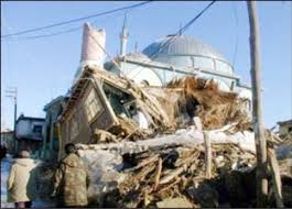
An earthquake occurred on November 27, 2005, at 13:52 IRST on the sparsely populated Qeshm Island off Southern Iran, killing 13 people and devastating 13 villages. It was Iran's second major earthquake of 2005, following the one at Zarand in February. The epicenter was about 1,500 kilometers (930 mi) south of Tehran, close to Iran's southern borders. Initial measurements showed that the earthquake registered about 6.0 on the moment magnitude scale, although that was reduced to 5.8 after further analysis. More than 400 minor aftershocks followed the main quake, 36 of which were greater than magnitude 2.5. The earthquake occurred in a remote area during the middle of the day, limiting the number of fatalities. Iranian relief efforts were effective and largely adequate, leading the country to decline offers of support from other nations and UNICEF.

The 1950 Assam–Tibet earthquake, also known as the Assam earthquake, occurred on 15 August and had a moment magnitude of 8.7. The epicentre was located in the Mishmi Hills. It is the strongest earthquake ever recorded on land.
Two earthquakes hit the Italian regions of Molise and Apulia on 31 October at 10:32:58 (UTC) and 1 November at 15:09:00 (UTC). The shocks had magnitudes of 5.9 and 5.8 respectively. Most of the victims were killed and injured when a school collapsed in the town of San Giuliano di Puglia: 26 of the 51 schoolchildren died, together with one of their teachers. In particular, none of the nine children in the school's 4th Year survived.
Striking southern Italy on 8 September, the 1905 Calabria earthquake had a moment magnitude of 7.2 and a maximum Mercalli intensity of XI (Extreme). The first major earthquake of the 20th century, it severely damaged parts of Lipari, Messina Province and a large area between Cosenza and Nicotera and killed between 557 and 2,500 people.

The 1976 Çaldıran–Muradiye earthquake occurred at 14:22 local time on 24 November. The epicenter was located near Çaldıran, 20 km northeast of Muradiye, in the Van Province of eastern Turkey. The earthquake had a magnitude of 7.3 with a maximum intensity of X (Extreme) on the Mercalli intensity scale. The area of severe damage, where over 80% of the buildings were destroyed, covered an area of 2,000 square kilometres. There were between 4,000 and 5,000 casualties.
The 1966 Toro earthquake, or the 1966 Ruwenzori earthquake, occurred on March 20 at 01:42 UTC. The earthquake was located near the border between Uganda and the Democratic Republic of the Congo (DRC), to the south of Lake Albert. Some sources put the epicenter in Uganda while some put it in the Democratic Republic of the Congo. The earthquake had a magnitude of 6.8 and a maximum perceived intensity of VIII (Severe) on the Mercalli intensity scale.
The 1935 Helena earthquake occurred at in Montana, with an epicenter near Helena. It had a magnitude of 6.2 on the surface-wave magnitude scale and a maximum perceived intensity of VIII (Severe) on the Mercalli intensity scale. The temblor on that date was the largest of a series of earthquakes that also included a large aftershock on October 31 of magnitude 6.0 and a maximum intensity of VIII. Two people died in the mainshock and two others died as a result of the October 31 aftershock. Property damage was over $4 million.
The 2000 Nicaragua earthquake occurred at 19:30 UTC on July 6. It had a magnitude of 5.4 on the moment magnitude scale and caused 7 deaths and 42 injuries. 357 houses were destroyed and 1,130 others were damaged in the earthquake.
The 1999 Aïn Témouchent earthquake occurred on December 22 at in northern Algeria. The dip-slip event had a moment magnitude of 5.6 and a maximum Mercalli intensity of VII. At least 22 were killed, 175 were injured, and 15,000–25,000 were made homeless. The Belgian Centre for Research on the Epidemiology of Disasters' EM-DAT database and the USGS' National Geophysical Data Center both list financial losses of $60.93 million.
The 1992 Murindó earthquake occurred on October 18 at 15:11 UTC with an epicenter in the Department of Chocó, northern Colombia. The shallow magnitude 7.2 earthquake struck northwest of the town of Murindó, killing ten and injured more than a hundred. Thirty-three municipalities were severely damaged.
The Afyon Province of western Turkey was struck by an earthquake measuring 6.5 on 3 February 2002 at 10:11 local time. It had a maximum felt intensity of VIII (Severe) on the Modified Mercalli intensity scale. It damaged hundreds of buildings and caused the deaths of 44 people and a further 318 injuries.
The 2020 Central Idaho earthquake occurred in the western United States on March 31, 2020, at 5:52 PM MDT, near Ruffneck Peak in the Sawtooth Mountains of central Idaho, 72 miles (116 km) northeast of Boise and 19 miles (31 km) northwest of Stanley. It had a magnitude of 6.5 and was felt with a maximum intensity of VIII.
The 2020 Kashgar earthquake, also known as the Jiashi earthquake occurred on 19 January 2020 at 21:27:56 China Standard Time in Xinjiang Province, China. According to the United States Geological Survey, the earthquake had a moment magnitude of 6.0 and a surface wave magnitude of 6.4 according to the China Earthquake Network Center. It struck at a shallow depth of 5.6 km according to the USGS while the CENC has the figure at 16 km. Local emergency management agencies said the earthquake damaged more than 1,000 homes and businesses in the nearby populated towns and villages. One person is known to have died while two other children were injured.
The 1995 Menglian earthquake or 1995 Myanmar–China earthquake occurred on 12 July at 05:46:43 local time in the Myanmar–China border region. The earthquake had an epicenter on the Myanmar side of the border, located in the mountainous region of Shan State. It registered 7.3 on the Chinese surface wave magnitude scale (Ms ) and 6.8 on the moment magnitude scale (Mw ). With a maximum Mercalli intensity assigned at VIII, it killed 11 people and left another 136 injured. Over 100,000 homes in both countries were destroyed and 42,000 seriously damaged. Some damage to structures were also reported in Chiang Mai and Chiang Rai, Thailand. The low death toll from this earthquake was attributed to an early warning issued prior to it happening. Precursor events including foreshocks and some seismic anomalies led to an evacuation of the area before the mainshock struck. It is thought to be one of the few successfully predicted earthquakes in history.
The 1555 Kashmir earthquake occurred at around midnight in the month of Ashvin in the Hindu calendar, or September in the Gregorian calendar, although the exact day of occurrence is not known. The earthquake seriously impacted the Kashmir Valley in present-day Pakistan and northwestern India. A moment magnitude (Mw ) of 7.6 to 8.0 and Modified Mercalli intensity of XII (Extreme) has been estimated for the earthquake. Thought to be one of the most destructive in the Kashmir Valley, the earthquake caused serious widespread damage and ground effects, killing an estimated 600–60,000 individuals.
On 9 July 2019, at 8:36 PM (PST), an earthquake measuring 5.6 jolted the province of North Cotabato, Davao del Sur, and other nearby provinces. The National Disaster Risk Reduction and Management Council reported one dead and three injured in Makilala after the earthquake, and a total of 164 families affected in Cotabato Province. Near the epicenter of the earthquake, the severity of strong ground motion was assigned VI (Strong) on the Modified Mercalli intensity scale. A total of 106 schools, 119 houses, and 14 other infrastructures were damaged by the earthquake.
The 1885 Kashmir earthquake, also known as the Baramulla earthquake occurred on 30 May in Srinagar. It had an estimated moment magnitude of Mw 6.3–6.8 and maximum Medvedev–Sponheuer–Karnik scale intensity of VIII (Damaging). At least 3,081 people died and severe damage resulted.
The second shock in the 1962 Irpinia earthquake sequence was the largest and most destructive in a series of earthquakes in the southern Apennines. It occurred on 21 August at 18:19 CET, measuring 6.15 and assigned a maximum intensity of IX (Violent). It was preceded by an Mw 5.68 foreshock, and followed by a 5.34 aftershock. The earthquakes resulted in nearly 20 fatalities and significant property losses.
The 1979 Saint Elias earthquake affected Alaska at 12:27 AKST on 28 February. The thrust-faulting 7.5 earthquake had an epicenter in the Granite Mountains. Though the maximum recorded Modified Mercalli intensity was VII, damage was minimal and there were no casualties due to the remoteness of the faulting. Damage also extended across the border in parts of Yukon, Canada.
The 1983 Kaoiki earthquake struck southern Hawaii Island on the morning of November 16, 1983. Measuring Mw 6.7, it was the largest to hit the island since 1975. The epicenter was located 50 km (30 mi) southeast of Hilo with an approximated depth of 12 km (7 mi). The shallow strike-slip earthquake was assigned a maximum intensity of IX (Violent) on the Modified Mercalli scale. 6 people were injured, widespread damage and landslides were reported across the island.
