
The Gulf of Aqaba or Gulf of Eilat is a large gulf at the northern tip of the Red Sea, east of the Sinai Peninsula and west of the Arabian Peninsula. Its coastline is divided among four countries: Egypt, Israel, Jordan, and Saudi Arabia.
The 1978 Tabas earthquake occurred on September 16 at 19:05:55 local time in central Iran. The shock measured 7.4 on the moment magnitude scale and had a maximum Mercalli intensity of IX+ (Violent). The death toll was in the range of 15,000–25,000, with severe damage occurring in the town of Tabas.

Shadwan is a barren rocky island 30 miles southwest of the Egyptian city of Sharm el-Sheikh on the Sinai Peninsula and 20 miles northeast of El Gouna. It is the largest of a group of islands in the mouth of the Gulf of Suez in the northern Red Sea and measures 16 kilometres (9.9 mi) in length, and between 3–5 kilometres (1.9–3.1 mi) wide. It was formerly also called Shaker Island and features a lighthouse. The island is famous as a touristic site for underwater diving and fishing.

The Red Sea Riviera, Egypt's eastern coastline along the Red Sea, consists of resort cities on the western shore of the Gulf of Aqaba and along the eastern coast of mainland Egypt, south of the Gulf of Suez. The combination of a favorable climate, warm sea, thousands of kilometers of shoreline and abundant natural and archaeological points of interest makes this stretch of Egypt's coastline a popular national and international tourist destination. There are numerous National Parks along the Red Sea Riviera, both underwater and on land. Desert and marine life are protected by a number of laws, and visitors may be subject to heavy fines for not abiding.
The 1929 Kopet Dag earthquake took place at 15:37 UTC on 1 May with a moment magnitude of 7.2 and a maximum Mercalli intensity of IX (Violent). It occurred in the Kopet Dag area of Iran and caused up to 3,800 casualties along the Turkmenistan-Iran border. More than 1,100 were injured.
The 1909 Borujerd earthquake also known as Silakhor earthquake occurred in Silakhor plain, Persia on January 23. Around 8,000 fatalities were caused directly from the magnitude 7.3 earthquake. An indefinite number of aftershocks continued for six months after the main shock. The section on this fault ruptured was the same as the main rupture zone of the 2006 Borujerd earthquake.
The 1930 Salmas earthquake occurred on in West Azerbaijan Province, Iran. The earthquake, which was among Iran's largest, measured 7.1 on the moment magnitude scale and had a maximum Mercalli intensity of IX (Violent). A damaging foreshock occurred fifteen hours prior to the main event and served as a warning to the people that felt it strongly. Reports from seismologists and seismological organizations indicate that up to 3,000 fatalities may have occurred in northwest Iran and southeast Turkey.
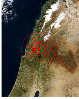
The Galilee earthquake of 1837, often called the Safed earthquake, shook the Galilee on January 1 and is one of a number of moderate to large events that have occurred along the Dead Sea Transform (DST) fault system that marks the boundary of two tectonic plates; the African Plate on the west and the Arabian Plate on the east. Intensity assessments for the event were VIII (Damaging) on the Medvedev–Sponheuer–Karnik scale and VIII on the European Macroseismic Scale.

The 1980 El Asnam earthquake occurred on October 10 at with a moment magnitude of 7.1 and a maximum Mercalli intensity of X (Extreme). The shock occurred in the Algerian town of El Asnam. The shocks were felt over 550 km (340 mi) away, with the initial earthquake lasting 35 seconds. It was the largest earthquake in Algeria, and was followed three hours later by a magnitude 6.2 aftershock. The earthquake created about 42 km (26 mi) of surface rupture and had a vertical slip of up to 4.2 m (14 ft). No foreshocks were recorded. The earthquake was found to have occurred very close to the epicenter of the 1954 Chlef earthquake using joint epicenter determination techniques. It occurred at a previously unknown reverse fault.
The 1982 North Yemen earthquake hit near the city of Dhamar, North Yemen on December 13. Measuring 6.2 on the moment magnitude scale, with a maximum perceived intensity of VIII (Severe) on the Mercalli intensity scale, as many as 2,800 people were killed and another 1,500 injured. The shock occurred within several hundred kilometers of a plate boundary in a geologically complex region that includes active volcanoes and seafloor spreading ridges. Yemen has a history of destructive earthquakes, though this was the first instrumentally recorded event to be detected on global seismograph networks.
The 1992 Cairo earthquake occurred at 15:09 local time on 12 October, with an epicenter near Dahshur, 35 km (22 mi) south of Cairo. The earthquake had a magnitude of either 5.8 or 5.9, but was unusually destructive for its size, causing 545 deaths, injuring 6,512 and making 50,000 people homeless. It was the most damaging seismic event to affect Cairo since 1847.
The 1995 Gulf of Aqaba earthquake occurred on November 22 at 06:15 local time and registered 7.3 on the scale. The epicenter was located in the central segment of the Gulf of Aqaba, the narrow body of water that separates Egypt's Sinai Peninsula from the western border of Saudi Arabia. At least 8 people were killed and 30 were injured in the meizoseismal area.
The 1927 Jericho earthquake was a devastating event that shook Mandatory Palestine and Transjordan on July 11 at . The epicenter of the earthquake was in the northern area of the Dead Sea. The cities of Jerusalem, Jericho, Ramle, Tiberias, and Nablus were heavily damaged and at least 287 were estimated to have been killed.
The 1955 Alexandria earthquake occurred on September 12 at 06:09 UTC. The epicenter was located in the eastern Mediterranean, offshore of Alexandria, Egypt. The earthquake had a magnitude of Ms 6.3.
The 1954 Chlef earthquake struck Chlef Province in Algeria on September 9 at . The shock measured 6.7 on the moment magnitude scale and had a maximum Mercalli intensity of XI (Extreme). It destroyed Chlef, then named Orléansville, leaving over 1,243 people dead and 5,000 injured. Damage was estimated at $6 million. It was followed by multiple aftershocks. Algeria faces annual earthquakes and has undergone several changes to its earthquake building codes since its first earthquake engineering regulations from 1717.
Two major earthquakes occurred in the Near East on 18 March and 29 May, AD 1068. The two earthquakes are often amalgamated by contemporary sources. The first earthquake had its epicentre somewhere in the northwestern part of the Arabian Peninsula around Tabuk, while the second was most damaging in the city of Ramla in Palestine, some 500 km to the northwest.
The 1963 Marj earthquake occurred on February 21 in northern Libya. The earthquake occurred at with a moment magnitude of 5.6 and a maximum Mercalli intensity of VIII (Severe). Financial losses totaled $5 million USD, with 290–375 deaths, 375–500 injuries, and 12,000 homeless.
The 1856 Heraklion earthquake, also known as the Crete earthquake or Rhodes earthquake occurred on the morning of October 12 at 02:45 am local time. This extremely catastrophic earthquake had an estimated magnitude of 7.7 to 8.3 at a depth of approximately 61 to 100 km. The earthquake was felt over a very wide area extending from Sicily, Italy to the Levant and North Africa. On the Greek island of Crete, the effects of the earthquake were cataclysmic, over 500 bodies were recovered in the city of Heraklion. Shockwaves from the earthquake were felt intensely, covering all of the Ottoman Empire; present-day Turkey, Cyprus and the Middle East where damage and human losses were reported. In Malta, the earthquake collapsed the Għajn Ħadid Tower—a coastal watchtower built around the year 1638. In Cairo, Egypt, the earthquake destroyed buildings, created seiches in canals, and killed several people. Off the Egyptian and Italian coasts, sailors reported feeling a seaquake.
The 1941 Sa'dah earthquake or the Jabal Razih earthquake occurred on January 11 in the Razih District of Yemen. The earthquake had a surface wave magnitude of 5.8–6.5 and a shallow focal depth. Despite the moderate size of this earthquake, an estimated 1,200 people perished and at least 200 injured. With a maximum MSK-64 intensity assigned at VIII, it destroyed many villages and collapsed homes in the region of North Yemen.
