1995 Gulf of Aqaba earthquake

Last updated

1995 Gulf of Aqaba earthquake
Egypt relief location map.jpg
Green pog.svg
Cairo
Bullseye1.png
Green pog.svg
Alexandria
Green pog.svg
Eilat
Green pog.svg
Nuweiba
UTC  time1995-11-22 04:15:11
ISC  event 70282
USGS-ANSS ComCat
Local dateNovember 22, 1995 (1995-11-22)
Local time06:15 [1]
Magnitude7.3 Mw [2]
Depth18 km (11 mi) [3]
Epicenter 28°49′34″N34°47′56″E / 28.826°N 34.799°E / 28.826; 34.799
Type Strike-slip
Areas affectedEgypt, Palestine, Israel, Jordan
Saudi Arabia
Max. intensity VIII (Severe) [4]
TsunamiYes [2] [5]
Casualties9–12 dead [6]
30–69 injured [7]

The 1995 Gulf of Aqaba earthquake (also known as Nuweiba earthquake) occurred on November 22 at 06:15 local time (04:15 UTC) and registered 7.3 on the Mw scale. The epicenter was located in the central segment of the Gulf of Aqaba, the narrow body of water that separates Egypt's Sinai Peninsula from the western border of Saudi Arabia. At least 8 people were killed and 30 were injured in the meizoseismal area.

Contents

The earthquake occurred along the Dead Sea Transform (DST) fault system, an active tectonic plate boundary with seismicity that is characterized by long-running quiescent periods with occasional large and damaging earthquakes, along with intermittent earthquake swarms. It was the strongest tectonic event in the area for many decades and caused injuries, damage, and deaths throughout the Levant and is also thought to have remotely triggered a series of small to moderate earthquakes 500 kilometers (310 mi) to the north of the epicenter. In the aftermath of the quake, several field investigations set out to determine the extent of any surface faulting, and the distribution of aftershocks was analyzed.

Tectonic setting

The Gulf of Aqaba is situated along the southern portion of the Dead Sea Transform (DST) fault zone, a 1,000 km (620 mi) transform fault that forms the barrier between the African Plate and the Arabian Plate (Arabian-Nubian Shield). The left-lateral strike-slip fault connects the spreading center that forms the Red Sea in the south with the East Anatolian Fault in Turkey in the north. Although there is much that is not known about the DST, it is accepted that its transform motion began around 12–18 million years ago. Geologist A. M. Quennell, who is credited with first recognizing the movement along the fault in 1958, estimated the total displacement to be 107 kilometers (66 mi) while a similar study that included more regional influences resulted in an estimated slip of 100 kilometers (62 mi). [2] That broader kinematic model translates into a slip rate of 8–10 mm/year for the portion of the fault south of the Dead Sea. [8]

Along the length of the Dead Sea Transform (also known as the Levantine fault) there are several pull-apart basins that have resulted in the formation of the Dead Sea as well as the Gulf of Aqaba. The 180 km (110 mi) gulf comprises three distinct pull-apart basins that were formed by individual segments of the fault and are known as (from north to south) the Elat Deep, Aragonese Deep, and the Dakar Deep. At 25 km (16 mi) wide, the gulf is relatively narrow, but is up to 1,800 meters (5,900 ft) deep, with the nearby mountains near 2,600 meters (8,500 ft) in height. This difference in elevation suggests that the tectonic activity outpaces the erosive processes in the area, but the background seismicity is infrequent and is marked by earthquake swarms. [9]

Stress triggering

USGS shakemap showing the intensity of the 1995 Gulf of Aqaba earthquake USGS Shakemap - 1995 Gulf of Aqaba earthquake.jpg
USGS shakemap showing the intensity of the 1995 Gulf of Aqaba earthquake

The earthquake was the largest event to occur on along the DST during the 20th century and was felt up to 600 km (370 mi) away. The period of aftershocks carried on for over a year with many exceeding magnitude 5. Within several hours of the mainshock a number of small earthquakes occurred along the DST 500 km (310 mi) north of the epicenter. Analysis of these earthquakes suggest that they may have been remotely triggered by the Gulf of Aqaba mainshock. Much attention has been given to remotely triggered earthquakes since the 1992 Landers earthquake in southern California. [3]

The Dead Sea fault system runs from the Red Sea north to a triple junction in south-central Turkey and consists of a main fault and several secondary faults. The fault system is at its widest and deepest in the gulf where a transition from proto-oceanic rifting to transform faulting occurs. Moving northward through Lebanon and Syria, where the DST is known as the Yammouneh fault, the trace follows a restraining bend and splits into several strands that include the Serghaya and Rachaya faults. These strands are believed to be the source of the Near East earthquakes of 1759. The increased seismic activity following the Aqaba earthquake was detected by the Syrian National Seismic Network (SNSN) and occurred in the area of the Serghaya and Rachaya faults within a 25 km × 25 km (16 mi × 16 mi) area near the restraining bend in southwest Syria. The SNSN consists of twenty vertical-component seismometers, but only nine instruments recorded the swarm. [10] [11]

This small area in southwest Syria situated 500 km north of the Gulf of Aqaba mainshock had almost no activity during the two previous months then, beginning two hours and 47 minutes after the event, a swarm of 21 small earthquakes occurred. The average background seismicity was .5 to 1 events per day preceding November 22, and during the swarm 21 small earthquakes with a peak magnitude of (Md = 3.7) were recorded in three and a half hours. Randa Mohamad (from the Syrian National Seismological Center) and other seismologists determined that the abrupt increase of activity was due to remote earthquake triggering from the Gulf of Aqaba mainshock, and reported the results of their investigation in a journal published by the Seismological Society of America. [12]

Damage

The epicenter was located 60 kilometers (37 mi) south of the head of the Gulf of Aqaba where the countries of Egypt, Israel, Jordan, and Saudi Arabia converge. Damage to buildings occurred in the coastal cities of Eilat, Israel and Aqaba, Jordan and a small tsunami was observed by witnesses there. Farther down the coast and closer to the epicenter in the Egyptian city of Nuweiba several well-built, modern, concrete reinforced homes were completely destroyed. [2]

The earthquake's effects were felt as far north as Lebanon and Syria and it was the strongest event in the Jordan Rift Valley since the 1927 Jericho earthquake which was centered near the Dead Sea. The heaviest damage occurred in the resort town of Eilat where seven hotels and 50 other buildings were damaged, and cracks formed in the sidewalks. Fifteen people were treated there for injuries or shock and one man died of a heart attack in Aqaba. In Saudi Arabia two women were reported dead and five deaths were reported in Egypt, with three of them occurring in the gulf resort town of Nuweiba. Eight buildings collapsed in Cairo where, just several years before, the much smaller 1992 Cairo earthquake had a much more destructive impact. [13] One person was killed and two were injured slightly at Al-Bad', Saudi Arabia and damage was reported there as well as the towns of Al-`Ula and Haql. [7] In Eilat, Israel, one person died of a heart attack, several people were injured and property damage, power cuts and liquefaction was observed. In Jerusalem, some damage was also observed. [7]

Past events

The Gulf of Aqaba lies between the Sinai Peninsula and the Arabian Peninsula, both mostly desert regions with very few permanent settlements. The seismologists who work with historical events gather macroseismic data from written records from cities that may not have been anywhere near the epicentral area. This can result in the mislocation of events when significant damage was reported in a particular location which were not actually where the earthquake occurred. The records of these events have been influenced by the distribution of the population (where the people were) and this has caused difficulty in creating a complete and accurate index of historical events. Several studies in the 80s and 90s indicate that there were two or possibly three large earthquakes in the region in the last 2000 years with magnitudes estimated to be 6.5–7.0 based on macroseismic data. [14]

The countries surrounding the gulf have been actively monitoring the seismicity there since the 1980s and have found a consistent low level of activity, but a primary characteristic of the activity is that there are multiple sequences of earthquake swarms. Three swarm events, beginning in the north and ending in the south gulf, have been observed beginning in 1983 when more than 1,000 events occurred over a three-month period near the northeastern boundary of the Elat Deep (in the northern gulf) with the largest three events approaching 5 on the Richter magnitude scale. A less pronounced swarm occurred in 1990 with the largest event reaching 4.3 in the central gulf near the Elat Deep and the Arogonese Deep. The last significant swarm happened in 1993 in the southwestern Arogonese Deep (in the southern gulf) with the highest magnitude of 6.1 and more than 300 larger than magnitude 3 in the following weeks. [14]

Aftermath

During several independent field studies cracks and other ground deformations were observed on both the Egyptian and Saudi Arabian sides of the gulf. During a field survey that was done there in 1996, a series of cracks were discovered between 28°35' N and 29°05' N on the Saudi Arabian coast. A field investigation was also done in Egypt in 1996 by seismologist Yann Klinger and others along with the Egyptian Geological Survey and Mining Authority. The most dramatic ground ruptures found were north of Nuweiba along a coastal road. [15]

The countries surrounding the gulf (Egypt, Israel, Jordan, and Saudi Arabia) operate their own seismic networks and during the months that followed the main event, fourteen temporary and permanent stations recorded thousands of aftershocks. Klinger acquired data on approximately 1,000 aftershocks via the European-Mediterranean Seismological Center and the agencies of each country. The data was filtered to include only those aftershocks within 150 km (93 mi) of the epicenter. Data from four stations from the Institute for Petroleum Research and Geophysics of Israel plus seven stations from Jordan's Natural Resource Authority recorded aftershocks in the epicentral area that met the restriction. It was found that the aftershocks were arranged with a north-south alignment over a length of 70 km (43 mi) and that was expected from an earthquake of such magnitude. The group of aftershocks were bunched in two distinct clusters, with one in the north and one further south. [16]

See also

Related Research Articles

<span class="mw-page-title-main">Earthquake</span> Sudden movement of the Earths crust

An earthquake is the shaking of the surface of the Earth resulting from a sudden release of energy in the Earth's lithosphere that creates seismic waves. Earthquakes can range in intensity, from those that are so weak that they cannot be felt, to those violent enough to propel objects and people into the air, damage critical infrastructure, and wreak destruction across entire cities. The seismic activity of an area is the frequency, type, and size of earthquakes experienced over a particular time. The seismicity at a particular location in the Earth is the average rate of seismic energy release per unit volume. The word tremor is also used for non-earthquake seismic rumbling.

<span class="mw-page-title-main">Gulf of Aqaba</span> Large gulf at the northern tip of the Red Sea

The Gulf of Aqaba or Gulf of Eilat is a large gulf at the northern tip of the Red Sea, east of the Sinai Peninsula and west of the Arabian Peninsula. Its coastline is divided among four countries: Egypt, Israel, Jordan, and Saudi Arabia.

<span class="mw-page-title-main">1976 Moro Gulf earthquake</span> Earthquake in the Philippines

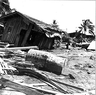
The 1976 Moro Gulf earthquake and tsunami occurred on August 17, 1976, at 00:11 local time near the islands of Mindanao and Sulu, in the Philippines. It meaured 8.0 on the moment magnitude scale occurring at a depth of 20 km (12 mi). The earthquake was accompanied by a destructive tsunami that resulted in a majority of the estimated 5,000 to 8,000 fatalities. It was the deadliest and strongest earthquake in the Philippines in 58 years since the 1918 Celebes Sea earthquake.

<span class="mw-page-title-main">2002 Denali earthquake</span> 7.9 magnitude; November 3, 2002

The 2002 Denali earthquake occurred at 22:12:41 UTC November 3 with an epicenter 66 km ESE of Denali National Park, Alaska, United States. This 7.9 Mw earthquake was the largest recorded in the United States in 37 years. The shock was the strongest ever recorded in the interior of Alaska. Due to the remote location, there were no fatalities and only one injury.

The 1984 Morgan Hill earthquake occurred on April 24 at 1:15 p.m. local time in the Santa Clara Valley of Northern California. The shock had a moment magnitude of 6.2 and a maximum Mercalli intensity of VIII (Severe). The epicenter was located near Mount Hamilton in the Diablo Range of the California Coast Ranges. Nearby communities sustained serious damage with financial losses of at least US$7.5 million.

The 1982 North Yemen earthquake hit near the city of Dhamar, North Yemen on December 13. Measuring 6.2 on the moment magnitude scale, with a maximum perceived intensity of VIII (Severe) on the Mercalli intensity scale, as many as 2,800 people were killed and another 1,500 injured. The shock occurred within several hundred kilometers of a plate boundary in a geologically complex region that includes active volcanoes and seafloor spreading ridges. Yemen has a history of destructive earthquakes, though this was the first instrumentally recorded event to be detected on global seismograph networks.

The 1986 Chalfant Valley earthquake struck southern Mono County near Bishop and Chalfant, California at 07:42:28 Pacific Daylight Time on July 21. With a moment magnitude of 6.2 and a maximum Mercalli intensity of VI (Strong), the shock injured two people and caused property damage estimated at $2.7 million in the affected areas. There was a significant foreshock and aftershock sequence that included a few moderate events, and was the last in a series of three earthquakes that affected southern California and the northern Owens Valley in July 1986.

The Brawley Seismic Zone (BSZ), also known as the Brawley fault zone, is a predominantly extensional tectonic zone that connects the southern terminus of the San Andreas Fault with the Imperial Fault in Southern California. The BSZ is named for the nearby town of Brawley in Imperial County, California, and the seismicity there is characterized by earthquake swarms.

The 1872 North Cascades earthquake occurred at 9:40 p.m. local time on December 14 in central Washington Territory. A maximum Mercalli intensity of VIII (Severe) was assessed for several locations, though less intense shaking was observed at many other locations in Washington, Oregon, and British Columbia. Some of these intermediate outlying areas reported V (Moderate) to VII shaking, but intensities as high as IV (Light) were reported as far distant as Idaho and Montana. Due to the remote location of the mainshock and a series of strong aftershocks, damage to structures was limited to a few cabins close to the areas of the highest intensity.

The 1979 Imperial Valley earthquake occurred at 16:16 Pacific Daylight Time on 15 October just south of the Mexico–United States border. It affected Imperial Valley in Southern California and Mexicali Valley in northern Baja California. The earthquake had a relatively shallow hypocenter and caused property damage in the United States estimated at US$30 million. The irrigation systems in the Imperial Valley were badly affected, but no deaths occurred. It was the largest earthquake to occur in the contiguous United States since the 1971 San Fernando earthquake eight years earlier.

The 1956 Chim earthquake was a destructive multiple-shock event that occurred on March 16 in Lebanon along a strand of the Dead Sea Transform (DST) fault system. The epicenter was located in the south of Lebanon in the Chouf District. Six thousand homes were destroyed and another 17,000 were damaged. The number of persons killed was 136.

Two major earthquakes occurred in the Near East on 18 March and 29 May, AD 1068. The two earthquakes are often amalgamated by contemporary sources. The first earthquake had its epicentre somewhere in the northwestern part of the Arabian Peninsula around Tabuk, while the second was most damaging in the city of Ramla in Palestine, some 500 km to the northwest.

The 1969 Sharm El Sheikh earthquake occurred on March 31 off the southern Sinai Peninsula in northeastern Egypt. The epicenter was located near Shadwan island, southwest of the city of Sharm El Sheikh, at the confluence of the Red Sea and the Gulf of Suez. This normal-slip shock measured 6.6 on the moment magnitude scale, had a maximum reported intensity of VII on the Mercalli intensity scale, and was responsible for several deaths and injuries.

The 1979 Coyote Lake earthquake occurred at 10:05:24 local time on August 6 with a moment magnitude of 5.7 and a maximum Mercalli Intensity of VII. The shock occurred on the Calaveras Fault near Coyote Lake in Santa Clara County, California and resulted in a number of injuries, including some that required hospitalization. Most of the $500,000 in damage that was caused was non-structural, but several businesses were closed for repairs. Data from numerous strong motion instruments was used to determine the type, depth, and extent of slip. A non-destructive aftershock sequence that lasted throughout the remainder of the month was of interest to seismologists, especially with regard to fault creep, and following the event local governments evaluated their response to the incident.

On January 1, 1996, at 4:05 p.m. Central Indonesia Time, an earthquake with an epicenter in the Makassar Strait struck north of Minahasa on the island of Sulawesi, Indonesia. The earthquake measured 7.9 on the moment magnitude scale and was centered off Tolitoli Regency in Central Sulawesi, or 25 km from the Tonggolobibi village. A tsunami of 2–4 m (6.6–13.1 ft) was triggered by this earthquake as a result. At least 350 buildings were badly damaged, nine people died and 63 people were injured.

The 1968 Borrego Mountain earthquake occurred on April 8, at 18:28 PST in the geologically active Salton Trough of Southern California. The Salton Trough represents a pull-apart basin formed by movements along major faults. This region is dominated by major strike-slip faults one of them being the San Jacinto Fault which produced the 1968 earthquake. The mainshock's epicenter was near the unincorporated community of Ocotillo Wells in San Diego County. The moment magnitude (Mw ) 6.6 strike-slip earthquake struck with a focal depth of 11.1 km (6.9 mi). The zone of surface rupture was assigned a maximum Modified Mercalli intensity (MMI) of VII.

The 1941 Sa'dah earthquake or the Jabal Razih earthquake occurred on January 11 in Razih District of the Mutawakkilite Kingdom of Yemen. The earthquake had a surface-wave magnitude of 5.8–6.5 and a shallow focal depth. Despite the moderate size of this earthquake, an estimated 1,200 people perished and at least 200 injured. With a maximum MSK-64 intensity assigned at VIII, it destroyed many villages and collapsed homes in the region of North Yemen.

The 2016 Alborian Sea earthquake struck offshore, north northeast of Al Hoceïma, Morocco in the Strait of Gibraltar on January 25 at 04:22:02 UTC, or roughly 05:22:02 West Africa Time. The strongest in the Alboran Sea, the earthquake measured 6.3–6.4 on the moment magnitude scale (Mw ) at a shallow hypocenter depth of 12 km (7.5 mi). Assigned a maximum Modified Mercalli scale intensity of VI (Strong), the earthquake caused one fatality, at least 30 injuries, and moderate damage in Morocco and Spain.

The 1997 Bojnurd earthquake occurred on 4 February at 14:07 IRST in Iran. The epicenter of the Mw 6.5 earthquake was in the Kopet Dag mountains of North Khorasan, near the Iran–Turkmenistan border, about 579 km (360 mi) northeast of Tehran. The earthquake is characterized by shallow strike-slip faulting in a zone of active faults. Seismic activity is present as the Kopet Dag is actively accommodating tectonics through faulting. The earthquake left 88 dead, 1,948 injured, and affected 173 villages, including four which were destroyed. Damage also occurred in Shirvan and Bojnord counties. The total cost of damage was estimated to be over US$ 30 million.

The 1957 Farsinaj earthquake struck Hamadan, Iran on 13 December at 05:15 local time. The moment magnitude 6.5 earthquake destroyed 211 villages, killed approximately 1,130 people, and left another 900 injured.

References

  1. USGS (December 1, 2008), EXPO-CAT Earthquake Catalog, Version 2007-12, United States Geological Survey
  2. 1 2 3 4 Klinger et al. 1999, p. 1025
  3. 1 2 Mohamad et al. 2000, p. 47
  4. National Geophysical Data Center / World Data Service (NGDC/WDS) (1972), Significant Earthquake Database (Data Set), National Geophysical Data Center, NOAA, doi:10.7289/V5TD9V7K
  5. Shaked, Y.; Agnon, A.; Lazar, B.; Marco, S.; Avner, U.; Stein, M. (2004), "Large earthquakes kill coral reefs" (PDF), Terra Nova, 16 (3): 137, Bibcode:2004TeNov..16..133S, CiteSeerX   10.1.1.539.2983 , doi:10.1111/j.1365-3121.2004.00541.x, S2CID   36218725
  6. USGS (September 4, 2009), PAGER-CAT Earthquake Catalog, Version 2008_06.1, United States Geological Survey
  7. 1 2 3 USGS. "Significant Earthquakes of the World — 1995". United States Geological Survey. Archived from the original on 2011-06-08.
  8. Klinger et al. 1999 , pp. 1025, 1026
  9. Klinger et al. 1999 , p. 1026
  10. Mohamad et al. 2000 , pp. 47–49
  11. Klinger, Y. The quaternary activity of the Levant fault: progress and challenges (PDF). ESC 2010 6–10 September, Montpellier, France - Keynotes. European-Mediterranean Seismologial Centre. p. 13.
  12. Mohamad et al. 2000 , pp. 49–51
  13. Segal, Naomi (November 22, 1995). "Mideast trembler rocks region, causing several deaths, damage". Jewish Telegraphic Agency. Archived from the original on November 6, 2013.(subscription required)
  14. 1 2 Klinger et al. 1999 , p. 1027
  15. Klinger et al. 1999 , pp. 1027, 1028
  16. Klinger et al. 1999 , p. 1030
Bibliography

Further reading