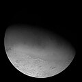
Ruach Planitia

Last updated

Ruach Planitia
PIA01538 Complex Geologic History of Triton.jpg
Voyager 2 image of Ruach Planitia. The crater Amarum is located to the lower right, and Dilolo Patera occupies much of Ruach Planitia's center. Parts of Tuonela Planitia can be seen at left
Feature typeWalled plain, cryolava lake
LocationMonad Regio, Triton
Coordinates 28°00′N24°00′E / 28.000°N 24.000°E / 28.000; 24.000 [1]
Diameter~175 km [2] :869
Depth~200 m [3] :106
Discoverer Voyager 2
EponymIsle of Ruach

Ruach Planitia is a roughly circular flat plain and probable cryolava lake on Neptune's moon Triton. It is located in Triton's northern hemisphere within Monad Regio and directly borders the cryovolcanic plains of Cipango Planum to the east and Tuonela Planitia to the west. Ruach Planitia, along with the other three walled plains of Triton, is one of the youngest and flattest features observed on the moon.

Contents

Discovery and naming

Ruach Planitia was discovered alongside Triton's other surface features by the Voyager 2 spacecraft during its flyby of the Neptune system on 25 August 1989. [4] The name Ruach Planitia was approved by the International Astronomical Union (IAU) in 1991; it is named after the legendary French isle of Ruach. [1]

Geology

Ruach Planitia is quasi-circular in shape and some 175–180 km in diameter. [2] :869 [5] The floor of Ruach Planitia is depressed by about 200 meters relative to the surrounding plains, [3] :106 with the floor surrounded by bounding scarp that ranges in height between 40 and 250 meters. [5] Most of Ruach Planitia is surrounded by a single bounding scarp, but on its east side the scarp appears to separate into two, giving a terraced profile. [6] :886 The floor of Ruach Planitia is generally flat, but may be subtly warped; given the limitations of Voyager 2 elevation data in the region, whether or not these are artifacts or true elevation features is uncertain. [7] The central region of Ruach Planitia is significantly more varied in topography compared to much of Ruach Planitia's floor, with a large central pit—Dilolo Patera— [8] nearly 10 km wide and roughly 350 m deep. Dilolo Patera is surrounded by a network of smaller pits, linear troughs, and scarps. [7] The pit cluster at Ruach Planitia is similar to the pit clusters found within the other three walled plains of Triton, with only a single pit cluster with the largest pit at the center of the plains. [6] :894 Both Ruach Planitia and nearby Tuonela Planitia cut into the surrounding cantaloupe terrain, and Ruach Planitia cuts into the western regions of Cipango Planum. [7]

Ruach Planitia's terraced appearance resembles that of terrestrial volcanic calderas, albeit at a very large scale. As with terrestrial calderas, eruptions from Ruach Planitia may have involved several distinct stages, with an early explosive stage of high-viscosity or high-volatility cryolava, a term for erupted water-dominated material analogous to silicate lava. These early eruptions form the terraced walls, with a later effusive stage that forms the flat floor. [6] :921 [9] :162 However, the crenulated appearance of the walls of Ruach Planitia do not appear to indicate collapse, and instead resemble eroded shorelines found on Earth. The multiple terraces on Ruach Planitia's eastern side may have arisen from compositional differences in different layers of Triton's crust, with some layers being more volatile than others. The flat floor of Ruach Planitia suggests that fluid cryolava infilled the depression, with the pits around Dilolo Patera acting as central vents whence material erupted from. [2] :870 [9] :219

The terrain surrounding Ruach Planitia appears to be significantly modified, with apparent glaciation. The cliffs of both Ruach Planitia and Tuonela Planitia appear to have been significantly eroded, with the north wall of Ruach Planitia apparently having been breached in at least three sites. The breach connects to an apparent channel system that stretches for at least ~230 km, though it extended beyond Triton's terminator and into the unimaged regions of Triton's night side at the time of Voyager 2's visit. It remains uncertain on which direction fluids may have flown within the channel, though tentative deposit features on the north floor of Ruach Planitia may indicate that material flowed into the plains, depositing eroded material onto the floor. [5] Several smaller subcircular depressions are located nearby Ruach Planitia to the south and southwest; these subcircular depressions may be of cryovolcanic origin or from diapirism. [10]

See also

Related Research Articles

<span class="mw-page-title-main">Triton (moon)</span> Largest moon of Neptune

Triton is the largest natural satellite of the planet Neptune. It is the only moon of Neptune massive enough to be rounded under its own gravity and hosts a thin but well-structured atmosphere. Triton orbits Neptune in a retrograde orbit—an orbit in the direction opposite to its planet's rotation—the only large moon in the Solar System to do so. Triton is thought to have once been a dwarf planet, captured from the Kuiper belt into Neptune orbit.

<span class="mw-page-title-main">Utopia Planitia</span> Impact basin on Mars

Utopia Planitia is a large plain within Utopia, the largest recognized impact basin on Mars and in the Solar System with an estimated diameter of 3,300 km (2,100 mi). It is the Martian region where the Viking 2 lander touched down and began exploring on September 3, 1976, and the Zhurong rover touched down on May 14, 2021, as a part of the Tianwen-1 mission. It is located at the antipode of Argyre Planitia, centered at 46.7°N 117.5°E. It is also in the Casius quadrangle, Amenthes quadrangle, and the Cebrenia quadrangle of Mars.

<span class="mw-page-title-main">Syrtis Major Planum</span> Martian shield volcano

Syrtis Major Planum is a massive shield volcano in the eastern hemisphere of Mars. A "dark spot", Syrtis Major Planum is located in the boundary between the northern lowlands and southern highlands of Mars just west of the impact basin Isidis in the Syrtis Major quadrangle. It was formerly believed to be a plain, and was therefore described as a planitia; later data from the Mars Global Surveyor revealed that it is actually a broad topographic rise. The dark color of Syrtis Major Planum comes from the basaltic volcanic rock of the region and the relative lack of dust.

<span class="mw-page-title-main">Cryovolcano</span> Type of volcano that erupts volatiles such as water, ammonia or methane, instead of molten rock

A cryovolcano is a type of volcano that erupts gases and volatile material such as liquid water, ammonia, and hydrocarbons. The erupted material is collectively referred to as cryolava; it originates from a reservoir of subsurface cryomagma. Cryovolcanic eruptions can take many forms, such as fissure and curtain eruptions, effusive cryolava flows, and large-scale resurfacing, and can vary greatly in output volumes. Immediately after an eruption, cryolava quickly freezes, constructing geological features and altering the surface.

<span class="mw-page-title-main">Crater chain</span> Line of craters along the surface of an astronomical body

A crater chain is a line of craters along the surface of an astronomical body. The descriptor term for crater chains is catena, plural catenae, as specified by the International Astronomical Union's rules on planetary nomenclature.

<span class="mw-page-title-main">Tempe Terra</span> Terra on Mars

Tempe Terra is a heavily cratered highland region in the northern hemisphere of the planet Mars. Located at the northeastern edge of the Tharsis volcanic province, Tempe Terra is notable for its high degree of crustal fracturing and deformation. The region also contains many small shield volcanoes, lava flows, and other volcanic structures.

Scalloped topography is common in the mid-latitudes of Mars, between 45° and 60° north and south. It is particularly prominent in the region of Utopia Planitia, in the northern hemisphere, and in the region of Peneus and Amphitrites Paterae in the southern hemisphere. Such topography consists of shallow, rimless depressions with scalloped edges, commonly referred to as "scalloped depressions" or simply "scallops". Scalloped depressions can be isolated or clustered and sometimes seem to coalesce. A typical scalloped depression displays a gentle equator-facing slope and a steeper pole-facing scarp. This topographic asymmetry is probably due to differences in insolation. Scalloped depressions are believed to form from the removal of subsurface material, possibly interstitial ice, by sublimation. This process may still be happening at present. This topography may be of great importance for future colonization of Mars because it may point to deposits of pure ice.

<span class="mw-page-title-main">Danube Planum</span> Plateau on Io

Danube Planum is a rifted mesa on the surface of Jupiter's moon Io. It is located on Io's trailing hemisphere at 22.73°S 257.44°W. Danube Planum is 244.22 kilometers across and 5.5 km tall. The mountain is bisected by a 15-to-25-kilometer-wide, northeast–southwest-trending canyon, splitting the mountain into two main east and west mountains, with several additional blocks at the southern end of the fracture. The outer margin of the plateau is marked by 2.6-to-3.4-km-tall scarps. Mass wasting in the form of landslide deposits are visible along the base of the western half of Danube Planum. Two volcanic depressions, known as paterae, lie at northern and southern ends of mountain. The volcano at the northern end, Pele, is one of the most active volcanoes on Io. One of the faults that helped form Danube Planum may also act as a conduit for magma to rise to the surface at Pele.

<span class="mw-page-title-main">Kraken Catena</span> Crater chain on Triton

Kraken Catena is a pit chain (catena) and likely tectonic fault on Triton, the largest natural satellite of Neptune. It, along with Set Catena, is located near and is aligned approximately radially from Leviathan Patera, a major cryovolcanic feature; as such, Kraken Catena may have played a role in rift-induced cryovolcanic activity in Leviathan Patera. Several of Kraken Catena's pits have central steep-sided knobs, giving a moated appearance similar to the moated mountains found on Pluto's moon Charon and Uranus's moon Ariel.

<span class="mw-page-title-main">Sotra Patera</span> Feature on Titan

Sotra Patera is a prominent depression on Titan, the largest moon of Saturn. It was formerly known as Sotra Facula; the current name was approved on 19 December 2012. It is a possible cryovolcanic caldera 30 km (19 mi) across and 1.7 km (1.1 mi) deep, and is immediately to the east of the largest putative cryovolcanic mountain on Titan, the 1.45 km (0.90 mi) high Doom Mons. Sotra Patera is the deepest known pit on Titan.

<span class="mw-page-title-main">Sputnik Planitia</span> Glaciated basin on Pluto

Sputnik Planitia is a large, partially glaciated basin on Pluto. About 1,400 by 1,200 km in size, Sputnik Planitia is partially submerged in large, bright glaciers of nitrogen ice. Named after Earth's first artificial satellite, Sputnik 1, it constitutes the western lobe of the heart-shaped Tombaugh Regio. Sputnik Planitia lies mostly in the northern hemisphere, but extends across the equator. Much of it has a surface of irregular polygons separated by troughs, interpreted as convection cells in the relatively soft nitrogen ice. The polygons average about 33 km (21 mi) across. In some cases troughs are populated by blocky mountains or hills, or contain darker material. There appear to be windstreaks on the surface with evidence of sublimation. The dark streaks are a few kilometers long and all aligned in the same direction. The planitia also contains pits apparently formed by sublimation. No craters were detectable by New Horizons, implying a surface less than 10 million years old. Modeling sublimation pit formation yields a surface age estimate of 180000+90000
−40000
years. Near the northwest margin is a field of transverse dunes, spaced about 0.4 to 1 km apart, that are thought to be composed of 200-300 μm diameter particles of methane ice derived from the nearby Al-Idrisi Montes.

<span class="mw-page-title-main">Vulcan Planitia</span> Major plain on Charon

Vulcan Planitia, or Vulcan Planum, is the unofficial name given to a large plain on the southern hemisphere of Pluto's moon Charon. It discovered by New Horizons during its flyby of Pluto in July 2015. It is named after the fictional planet Vulcan in the science-fiction series Star Trek. The name is not approved by International Astronomical Union (IAU) as of 2024.

<span class="mw-page-title-main">Wright Mons</span> Mountain on Pluto

Wright Mons is a large, roughly circular mountain and likely cryovolcano on the dwarf planet Pluto. Discovered by the New Horizons spacecraft in 2015, it is located southwest of Sputnik Planitia within Hyecho Palus, adjacent to the Tenzing Montes and Belton Regio. A relatively young geological feature, Wright Mons has attracted attention as one of the most apparent examples of recent geological activity on Pluto and borders numerous other similarly young features. Numerous semi-regular hills surround and partially construct the flanks of Wright Mons. Their nature remains unexplained, with few, if any, direct analogs elsewhere in the Solar System.

The Thaumasia Plateau is a vast sloping volcanic plain in the western hemisphere of Mars, and is the most extensive component of the Tharsis Rise by area. Syria Planum, Solis Planum, Sinai Planum, and Thaumasia Planum are the constituent sectors of the plateau, which sits between 8 km and 4 km above the surrounding southern highlands. It is bounded by vestigial basement terrains that predate the formation of Tharsis. This area has been proposed to be a drainage basin that sourced the floodwaters forming the outflow channels surrounding Chryse Planitia.

<span class="mw-page-title-main">Set Catena</span> Crater chain on Triton

Set Catena is a pit chain (catena) and likely tectonic fault located on Triton, the largest natural satellite of Neptune. It, along with Kraken Catena, is located near Leviathan Patera, a major cryovolcanic feature; as such, Set Catena may have played a role in rift-induced cryovolcanic activity in Leviathan Patera. Set Catena extends radially northwards from Leviathan Patera, terminating at another irregularly-shaped walled depression. Set Catena consists of semi-regularly spaced pits roughly 20 km separated from each other, with each pit being on average 10 km wide and up to 500 m deep. The pits may have formed from collapse or from explosive cryovolcanic eruptions, and may have been subsequently expanded by mass wasting processes. Set Catena may be a northeastern extension of Raz Fossae, a similar fault system southwest of Leviathan Patera.

<span class="mw-page-title-main">Pharos (crater)</span> Crater on Proteus

Pharos is the largest known impact crater on Neptune's moon Proteus. It is named after the island of Pharos, making it the only named surface feature on Proteus as of 2024. It measures 10–15 km deep and has a diameter of around 250 km (160 mi) in diameter, making it more than half the diameter of Proteus itself. The impact that created Pharos may have also created Hippocamp, due to how unusually close it is to Proteus.

<span class="mw-page-title-main">Leviathan Patera</span> Caldera on Triton

Leviathan Patera is a major cryovolcanic caldera on Neptune's largest moon Triton. Discovered by the Voyager 2 spacecraft in 1989, Leviathan Patera is located in Monad Regio and within Cipango Planum's western regions. Leviathan Patera is approximately 80 kilometers in diameter and may be the center of one of the largest cryovolcanic or volcanic edifices in the Solar System.

<span class="mw-page-title-main">Geology of Triton</span> Geologic structure and composition of Triton

The geology of Triton encompasses the physical characteristics of the surface, internal structure, and geological history of Neptune's largest moon Triton. With a mean density of 2.061 g/cm3, Triton is roughly 15-35% water ice by mass; Triton is a differentiated body, with an icy solid crust atop a probable subsurface ocean and a rocky core. As a result, Triton's surface geology is largely driven by the dynamics of water ice and other volatiles such as nitrogen and methane. Triton's geology is vigorous, and has been and continues to be influenced by its unusual history of capture, high internal heat, and its thin but significant atmosphere.

<span class="mw-page-title-main">Tuonela Planitia</span> Walled plain on Triton

Tuonela Planitia is an elongated plain and probable cryolava lake on Neptune's moon Triton. Located in Triton's northern hemisphere within Monad Regio, it overlies part of Triton's unusual cantaloupe terrain. As with neighboring Ruach Planitia and the other walled plains on Triton, Tuonela Planitia is among the youngest features on Triton's surface.

References

  1. 1 2 "Ruach Planitia". Gazetteer of Planetary Nomenclature. USGS Astrogeology Research Program. (Center Latitude: 28.00°, Center Longitude: 24.00°)
  2. 1 2 3 McKinnon, William B.; Kirk, Randloph L. (2014). Encyclopedia of the Solar System (Third ed.). doi:10.1016/C2010-0-67309-3. ISBN   978-0-12-415845-0 . Retrieved 15 April 2024.
  3. 1 2 Kargel, J. S. (1995). "Cryovolcanism on the Icy Satellites". Earth, Moon, and Planets. 67 (1–3): 101–113. Bibcode:1995EM&P...67..101K. doi:10.1007/BF00613296. S2CID   54843498 . Retrieved 12 March 2024.
  4. Bolles, Dana (March 2024). "Voyager 2". NASA.
  5. 1 2 3 Sulcanese, Davide; Cioria, Camilla; Kokin, Osip; Mitri, Giuseppe; Pondrelli, Monica; Chiarolanza, Giancula (March 2023). "Geological analysis of Monad Regio, Triton: Possible evidence of endogenic and exogenic processes". Icarus. 392. Bibcode:2023Icar..39215368S. doi:10.1016/j.icarus.2022.115368. S2CID   254173536 . Retrieved 12 March 2024.
  6. 1 2 3 Croft, S. K.; Kargel, J. S.; Kirk, R. L.; et al. (1995). "The geology of Triton". Neptune and Triton: 879–947. Bibcode:1995netr.conf..879C.
  7. 1 2 3 Schenk, Paul; Beddingfield, Chloe; Bertrand, Tanguy; et al. (September 2021). "Triton: Topography and Geology of a Probable Ocean World with Comparison to Pluto and Charon". Remote Sensing. 13 (17): 3476. Bibcode:2021RemS...13.3476S. doi: 10.3390/rs13173476 .
  8. "Dilolo Patera". Gazetteer of Planetary Nomenclature. USGS Astrogeology Research Program. (Center Latitude: 26.00°, Center Longitude: 24.50°)
  9. 1 2 Gregg, Tracy K. P.; Lopes, Rosaly M. C.; Fagents, Sarah A. (December 2021). Planetary Volcanism across the Solar System. doi:10.1016/B978-0-12-813987-5.00005-5. ISBN   978-0-12-813987-5. S2CID   245084572 . Retrieved 12 March 2024.
  10. Martin-Herrero, A.; Ruiz, J.; Romeo, I. (March 2014). Characterization and Possible Origin of Sub-Circular Depressions in Ruach Planitia Region, Triton (PDF). 45th Lunar and Planetary Science Conference. The Woodlands, Texas. Bibcode:2014LPI....45.1177M.