
Sacramento is the capital city of the U.S. state of California and the county seat of Sacramento County. Located at the confluence of the Sacramento and American Rivers in Northern California's Sacramento Valley, Sacramento's 2020 population of 524,943 makes it the fourth-most populous city in Northern California, sixth-most populous city in the state, and the ninth-most populous state capital in the United States. Sacramento is the seat of the California Legislature and the Governor of California.

Roseville is the most populous city in Placer County, California, located within the Sacramento metropolitan area. As of 2019, the US Census Bureau estimated the city's population to be 141,500. Interstate 80 runs through Roseville and State Route 65 runs through part of the northern edge of the city.

Redding is the economic and cultural capital of the Shasta Cascade region of Northern California and the county seat of Shasta County. Redding lies along the Sacramento River, 162 miles (261 km) north of Sacramento, and 120 miles (190 km) south of California's northern border with Oregon. Its population is 95,542 as of 2022, up from 93,611 at the 2020 census.
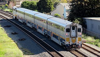
The San Joaquins is a passenger train service operated by Amtrak in California's San Joaquin Valley. Six daily round trips run between its southern terminus at Bakersfield and Stockton, with onward service to Sacramento and Oakland.

The California State Railroad Museum is a museum in the California State Parks system that interprets the role of railroads in the West. It is located in Old Sacramento State Historic Park at 111 I Street, Sacramento, California.

The Central California Traction Company is a Class III short-line railroad operating in the northern San Joaquin Valley, in San Joaquin County, California. It is owned jointly by the Union Pacific and BNSF Railway.

The Sacramento Northern Railway was a 183-mile (295 km) electric interurban railway that connected Chico in northern California with Oakland via the California capital, Sacramento. In its operation it ran directly on the streets of Oakland, Sacramento, Yuba City, Chico, and Woodland and ran interurban passenger service until 1941 and freight service into the 1960s.

Sacramento Valley Station is an Amtrak railway station in the city of Sacramento, California, at 401 I Street on the corner of Fifth Street, built in 1926 on the site of China Slough. It is the thirteenth busiest Amtrak station in the country, and the second busiest in the Western United States. It is served by four different Amtrak train routes and connecting Amtrak Thruway motorcoaches. It is also the western terminus for the Gold Line of the Sacramento RT Light Rail system and the Route 30 bus serving Sacramento State University.
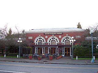
The Oregon Electric Railway Passenger Station is a historic railroad station in Eugene, Oregon, United States. It was built in 1914 as a station for the Oregon Electric Railway and was designed by A. E. Doyle.

Martinez station is an Amtrak passenger train station in Martinez, California, United States. Located at the west end of downtown Martinez, the station has one side platform and one island platform, which serve three of the four tracks of the Union Pacific Railroad Martinez Subdivision. It is served by the daily California Zephyr and Coast Starlight long-distance trains, five daily round trips of the San Joaquin corridor service, and fifteen daily round trips of the Capitol Corridor service. Martinez is also served by Amtrak Thruway buses plus County Connection, Tri-Delta Transit, and WestCAT local buses.

City College station is an at-grade light rail station on the Blue Line of the Sacramento RT Light Rail system operated by the Sacramento Regional Transit District. The station is located in an exclusive right-of-way alongside the Union Pacific Railroad's Sacramento Subdivision and a small rail yard, on the campus of Sacramento City College, after which the station is named, in the city of Sacramento, California.
Midtown Sacramento is a historical district and neighborhood just east of Downtown Sacramento. Officially, Midtown's borders are R Street on the South, J Street on the North, 16th Street on the West and 30th Street on the East. However, the streets in Sacramento's original "grid" that are east of 16th Street cover the area commonly called "Midtown". This more general definition covers an area bounded by Broadway on the South, C street and the Southern Pacific rail lines on the North, 16th Street on the West and Alhambra Boulevard on the East.

29th Street is a side platformed Sacramento RT light rail station in the Midtown neighborhood of Sacramento, California, United States. The station was opened on September 5, 1987, and is operated by the Sacramento Regional Transit District. It is served by the Gold Line. The station is located on R Street between 29th and 30th Streets, below the overpass of Business Loop 80, and is the easternmost station in the Central City Fare Zone. Portions of the Poverty Ridge neighborhood are also accessible from the station.

The Gold Line is a light rail transit line in the Sacramento Regional Transit District (RT) light rail system. Operating between Sacramento Valley and Historic Folsom stations, the line runs primarily east-west in Sacramento, portions of unincorporated Sacramento County, Rancho Cordova, Gold River and Folsom. Segments of the Gold Line run along the system's original alignment between 16th Street and Butterfield stations, which opened for service in 1987. The line has run in its modern configuration since June 2005, with extensions completed since then to Folsom and the downtown Amtrak station.
The Calpak Plant No. 11 in Sacramento, California, is a building built in 1925. Calpak constructed the building as a fruit cannery but it is now used by Blue Diamond Almonds It was listed on the National Register of Historic Places in 1984.

K Street is a historic street in Sacramento, California, United States. It spans from Old Sacramento, through Downtown Sacramento and Midtown Sacramento, ending in East Sacramento. Other discontinuous segments of K Street in East Sacramento are small residential streets, with the final segment ultimately ending at 54th Street. K Street is known primarily as a shopping, dining and entertainment destination for Downtown, Midtown, and Old Sac.

Transportation in the Sacramento metropolitan area consists of a variety of modes of travel in El Dorado County, Placer County, Sacramento County, and Yolo County, which are the four counties that comprise the Sacramento metropolitan area.
Midtown Sacramento is a planned train station in the neighborhood of the same name that will be a stop on Altamont Corridor Express and Amtrak California's San Joaquin services. To be constructed as part of the Valley Rail project, it was expected to open no later than 2023. By 2023, the opening date had slipped to 2026. The platform will run between P Street and the wye at S Street and be bisected by Q Street. Sacramento RT Light Rail stations are located either three blocks to the east or west.
Old North Sacramento is a planned train station that will be a stop on Altamont Corridor Express and Amtrak California's San Joaquin services. The station is located near the intersection of El Monte Avenue and Acoma Street. To be constructed as part of the Valley Rail project, it is expected to open by 2029. The Sacramento RT Light Rail Globe station is located nearby to the east.
The Sacramento Subdivision is a rail line owned and operated by the Union Pacific Railroad in the U.S. state of California. The line begins in Marysville as a continuation of the Canyon Subdivision at a junction with the Valley Subdivision, and travels south through the Central Valley to a junction with the Fresno Subdivision in Stockton. South of Downtown Sacramento, the Sacramento RT Light Rail Blue Line runs adjacent to the right of way until a flyover near Consumnes River Boulevard. The route between Sacramento and Stockton hosts about 12 to 20 freight trains daily as of 2018. Additionally, the Amtrak Coast Starlight runs over the tracks between Marysville and Sacramento.
