Hayabusa was a robotic spacecraft developed by the Japan Aerospace Exploration Agency (JAXA) to return a sample of material from a small near-Earth asteroid named 25143 Itokawa to Earth for further analysis. Hayabusa, formerly known as MUSES-C for Mu Space Engineering Spacecraft C, was launched on 9 May 2003 and rendezvoused with Itokawa in mid-September 2005. After arriving at Itokawa, Hayabusa studied the asteroid's shape, spin, topography, color, composition, density, and history. In November 2005, it landed on the asteroid and collected samples in the form of tiny grains of asteroidal material, which were returned to Earth aboard the spacecraft on 13 June 2010.

The Japan Aerospace Exploration Agency (JAXA) is the Japanese national air and space agency. Through the merger of three previously independent organizations, JAXA was formed on 1 October 2003. JAXA is responsible for research, technology development and launch of satellites into orbit, and is involved in many more advanced missions such as asteroid exploration and possible human exploration of the Moon. Its motto is One JAXA and its corporate slogan is Explore to Realize.
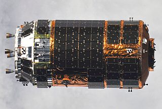
The H-II Transfer Vehicle (HTV), also called Kounotori, is an expendable Japanese automated cargo spacecraft designed for International Space Station (ISS) resupply missions, particularly the Kibō Japanese Experiment Module (JEM).

The Tanegashima Space Center (TNSC) is the largest rocket-launch complex in Japan with a total area of about 9,700,000 square metres. It is located on the southeastern tip of Tanegashima, an island approximately 40 kilometers (25 mi) south of Kyushu, an island and region and Japan. Construction on the site started in 1966. It was established in 1969 when the National Space Development Agency of Japan (NASDA) was formed, and is now run by JAXA. The activities that take place at TNSC include assembly, testing, launching, and tracking satellites, as well as rocket engine firing tests.

The Uchinoura Space Center is a space launch facility in the Japanese town of Kimotsuki, Kagoshima Prefecture. Before the establishment of the JAXA space agency in 2003, it was simply called the Kagoshima Space Center (鹿児島宇宙空間観測所) (KSC). All of Japan's scientific satellites were launched from Uchinoura prior to the M-V launch vehicles being decommissioned in 2006. It continues to be used for suborbital launches, stratospheric balloons and has also been used for the Epsilon orbital launch vehicle. Additionally, the center has antennas for communication with interplanetary space probes.
Institute of Space and Astronautical Science, or ISAS, is a Japanese national research organization of astrophysics using rockets, astronomical satellites and interplanetary probes which played a major role in Japan's space development. Since 2003, it is a division of Japan Aerospace Exploration Agency (JAXA).

Akatsuki, also known as the Venus Climate Orbiter (VCO) and Planet-C, was a Japan Aerospace Exploration Agency (JAXA) space probe tasked with studying the atmosphere of Venus. It was launched aboard an H-IIA 202 rocket on 20 May 2010, but failed to enter orbit around Venus on 6 December 2010. After the craft orbited the Sun for five years, engineers successfully placed it into an alternative Venusian elliptic orbit on 7 December 2015 by firing its attitude control thrusters for 20 minutes and made it the first Japanese satellite orbiting Venus.

Suzaku was an X-ray astronomy satellite developed jointly by the Institute of Space and Aeronautical Science at JAXA and NASA's Goddard Space Flight Center to probe high-energy X-ray sources, such as supernova explosions, black holes and galactic clusters. It was launched on 10 July 2005 aboard the M-V launch vehicle on the M-V-6 mission. After its successful launch, the satellite was renamed Suzaku after the mythical Vermilion bird of the South.

H-IIB (H2B) was an expendable space launch system jointly developed by the Japanese government's space agency JAXA and Mitsubishi Heavy Industries. It was used to launch the H-II Transfer Vehicle cargo spacecraft for the International Space Station. The H-IIB was a liquid-fueled rocket, with solid-fuel strap-on boosters and was launched from the Tanegashima Space Center in southern Japan. H-IIB made its first flight in 2009, and had made a total of nine flights through 2020 with no failures.
Joshibi University of Art and Design is a private women's art school in Suginami and Sagamihara in Japan.

Kanagawa Prefectural Sagamihara Yaei High School is a high school located in Sagamihara, Kanagawa Prefecture, Japan. Founded in 1983 as Yaei East (弥栄東) and Yaei West (弥栄西), the two schools merged in 2008. They were merged as part of the "Kanagawa 100 New High Schools" plan.
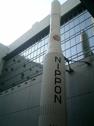
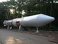
The N-I or N-1 was a derivative of the American Thor-Delta rocket, produced under license in Japan. The N stood for "Nippon" (Japan). It used a Long Tank Thor first stage, a Mitsubishi Heavy Industries-designed LE-3 engine on the second stage, and three Castor SRMs. Seven were launched between 1975 and 1982, before it was replaced by the N-II. Six of the seven launches were successful, however on the fifth flight, there was recontact between the satellite and the third stage, which caused the satellite to fail.
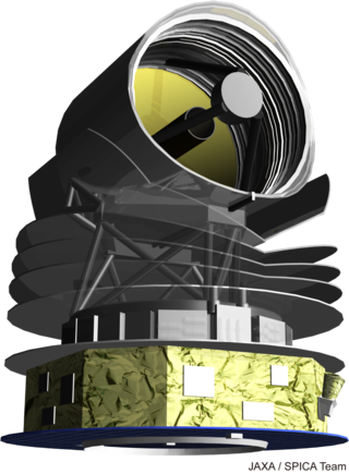
The Space Infrared Telescope for Cosmology and Astrophysics (SPICA), was a proposed infrared space telescope, follow-on to the successful Akari space observatory. It was a collaboration between European and Japanese scientists, which was selected in May 2018 by the European Space Agency (ESA) as a finalist for the next Medium class Mission 5 (M5) of the Cosmic Vision programme, to launch in 2032. At the time the other two finalists were THESEUS and EnVision, with the latter that was eventually selected for further development. SPICA would have improved on the spectral line sensitivity of previous missions, the Spitzer and Herschel space telescopes, between 30 and 230 μm by a factor of 50—100.
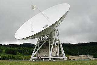
Usuda Deep Space Center is a facility of the Japan Aerospace Exploration Agency. It is a spacecraft tracking station in Saku, Nagano, opened in October, 1984. The main features of the station are two large beam waveguide antennas, an older 64 meter antenna and a newer 54 meter dish.

Chōfu Aerospace Center is the headquarters and main development facility for the Japan Aerospace Exploration Agency (JAXA).

Kounotori 3, also known as HTV-3, was the third flight of the Japanese H-II Transfer Vehicle. It was launched on 21 July 2012 to resupply the International Space Station (ISS) aboard the H-IIB Launch Vehicle No. 3 manufactured by Mitsubishi Heavy Industries (MHI) and JAXA. Kounotori 3 arrived at the ISS on 27 July 2012, and Expedition 32 Flight Engineer and JAXA astronaut Akihiko Hoshide used the International Space Station's Canadarm2 robotic arm to install Kounotori 3, to its docking port on the Earth-facing side (nadir) of the Harmony module at 14:34 UTC.
The (Japanese) Lunar Exploration Program is a program of robotic and human missions to the Moon undertaken by the Japanese Aerospace Exploration Agency (JAXA) and its division, the Institute of Space and Astronautical Science (ISAS). It is also one of the three major enterprises of the JAXA Space Exploration Center (JSPEC). The main goal of the program is "to elucidate the origin and evolution of the Moon and utilize the Moon in the future".

The Epsilon Launch Vehicle, or Epsilon rocket, is a Japanese solid-fuel rocket designed to launch scientific satellites. It is a follow-on project to the larger and more expensive M-V rocket which was retired in 2006. The Japan Aerospace Exploration Agency (JAXA) began developing the Epsilon in 2007. It is capable of placing a 590 kg payload into Sun-synchronous orbit.

CALLISTO is a reusable VTVL demonstrator propelled by a small 40 kN Japanese LOX-LH2 rocket engine. It is being developed jointly by the French (CNES), German (DLR) and Japanese (JAXA) national space agencies.