Earth Observation Center

Last updated

Entrance to the Earth Observation Center (November 2012) Higashimatsuyama Earth Observation Center Entrance 1.jpg
Entrance to the Earth Observation Center (November 2012)

The Earth Observation Center is a Japanese Aerospace Exploration Agency (JAXA) aeronautical research facility located in Hatoyama, Saitama, Japan. It utilizes remote sensing technologies such as satellites to study Earth's environment from outer space. The research done by this center has a substantial impact on the study of the Earth's environmental phenomena, such as global warming.

Contents

Background

The Earth Observation Center was established in Hatoyama, Saitama in October 1978 to process data from many satellites in orbit. It was created as a part of the National Space Development Agency of Japan (NASDA) Office of Earth Observation Systems. After NASDA merged its operations into JAXA in 2003, the EOC was also absorbed by JAXA. The EOC still exists as an integral component to JAXA's operations in the satellite imagery sector. [1]

Function

The primary function of the EOC is to collect, process, and archive imaging data from satellites in orbit. The EOC then sends the processed data to the Remote Sensing Technology Center of Japan (RESTEC), which is a center that receives this data and processes it for distribution to researchers and the public. [1] This information is also stored on magnetic tape data storage in the EOC's archives and is converted into simple images which are available to the scientific community (laboratories, universities, governments) as well as to the general public through DVD's. The distribution of this data is used to monitor for environmental disasters as well as educate the world about environmental issues. The ultimate goal of the EOC is to describe Japan's future climate change as well as build upon the remote sensing technologies. [2]

Facility

The Earth Observation Center covers an area of 115,000 m2 - spread among a main building and two supplemental buildings. The EOC has many instruments used for high-resolution satellite imagery and the development of sensors for remote sensing satellites. [3] These instruments include four parabolic antenna - two 10 meters, one 11.5 meters, one 13 meters in diameter - spread throughout the EOC campus which each channel data to high-density digital tape recorders for magnetic tape data storage. The EOC can handle 30 camera photos and 30 images from the Synthetic Aperture Radar, a radar that captures images of an object based on the object's relative motion, of the satellite JERS-1. [1]

The Earth Observation Center is known for cherry blossoms in spring (7 April 2009). EOC Spring.jpg
The Earth Observation Center is known for cherry blossoms in spring (7 April 2009).

Contributions

The EOC has had an impact on the study of contemporary environmental phenomena of Earth including El Niño, Greenhouse Gases, and the cryosphere as well as environmental disasters such as fires, typhoons, and floods.

Environmental Analysis

Greenhouse Gases

One of the facets of the environment the EOC is known for analyzing is the study of greenhouse gases in the atmosphere.

The EOC conducted a three-month study for the monitoring of greenhouse gases lasting from January 2009 to March 2009 with the Izuki satellite. The Izuki determined the amount of visible light absorbed by the different levels of Earth's atmosphere. The EOC translated this light absorption data into a chart and determined the change in atmospheric greenhouse gas concentration. The EOC will continue to use this satellite to gather light data in order to determine if the amount of atmospheric greenhouse gas is increasing (a root of global warming). [4]

Cryosphere

Most of the EOC's study on Earth's cryosphere deals with the ice levels in the world, namely the Arctic and Antarctic sea ice levels.

The facility has conducted a study on Earth's water cycle through a quantitative analysis of Arctic sea ice shrinkage. The Aqua and Shizuku satellites compiled data used by the EOC to quantify the concentration of Arctic sea ice. The EOC determined how much ice melts throughout the course of a year and how global warming has affected the Arctic ice cap. [5]

Disaster Analysis

Fires

The EOC has been involved in the analysis of fires - not just in Japan, but all across the Pacific including the United States.

Following the Southern California wildfires of October 2007, the EOC utilized the moisture, temperature, and humidity data of Southern California from the Aqua satellite in order to determine the cause of the fires. The analysis of the data done by the EOC showed that the soil moisture content dropped to very low levels on October 19. The analysis also showed that during the fires, the dry Santa Ana winds blew through Southern California and fueled the raging fires which lasted until early November. [6]

Floods

The EOC also performs analysis on the effect flooding has in regions such as Southeast Asia.

During the flood in Thailand from July to December 2011, the EOC gathered images from the satellites Daichi and Izuki and created a graphic that illustrated the withdrawal of flood water from Thailand back into the Gulf of Thailand. This graphic shows that most of the flood water receded during the month of December - effectively ending the Thailand flood. [7]

Satellites

Many satellites commissioned by JAXA and aeronautical institutions rest of the world share images and data with the EOC. Some of these satellites include: [8]

- Advanced Earth Observing Satellite (ADEOS) was launched by NASDA in August 1996 but was put out-of-order in July 1997 due to structural damage.

- Advanced Earth Observation Satellite-II (ADEOS-II) was launched by NASDA in December 2002 but failed due to a faulty solar panel in October 2003.

- Advanced Land Observing Satellite (ALOS) is a satellite launched by JAXA in January 2006. It is used to map terrain in Asia and the Pacific.

- Earth Observing System-PM1 (AQUA) is a multi-national satellite commissioned by America's NASA in May 2002.

- European Remote Sensing Satellite (ERS) was the ESA's first Earth-observing satellite and was launched in July 1991.

- Greenhouse Gases Observing Satellite (GOSAT), also known as Ibuki, is a satellite launched by JAXA in January 2009 and is used to monitor concentration levels of greenhouse gases such as carbon monoxide and methane.

- Japanese Earth Resources Satellite-1 (JERS-1) was a satellite commissioned by JAXA in 1992 and operated until 1998.

- Land Satellite (LANDSAT) series from the Landsat program is a set of seven satellites commissioned by America's NOAA between 1972 and 1999. These satellites are designed to capture images of Earth.

- Marine Observation Satellite (MOS) was Japan's first observation satellite, it has been inactive since November 1995.

- Satellite Probatoire d'Observation de la Terre (SPOT) was initialized by and is mostly used by the French organization CNES but is also utilized by the EOC.

- Shizuku (satellite) (GCOM-W1) is a satellite launched in May 2012 and is used to observe Earth's water cycle.

- Tropical Rainfall Measuring Mission (TRMM) satellite is part of the joint mission between JAXA and NASA designed to monitor and study rainfall.

Related Research Articles

The Earth Observing System (EOS) is a program of NASA comprising a series of artificial satellite missions and scientific instruments in Earth orbit designed for long-term global observations of the land surface, biosphere, atmosphere, and oceans. Since the early 1970s, NASA has been developing its Earth Observing System, launching a series of Landsat satellites in the decade. Some of the first included passive microwave imaging in 1972 through the Nimbus 5 satellite. Following the launch of various satellite missions, the conception of the program began in the late 1980s and expanded rapidly through the 1990s. Since the inception of the program, it has continued to develop, including; land, sea, radiation and atmosphere. Collected in a system known as EOSDIS, NASA uses this data in order to study the progression and changes in the biosphere of Earth. The main focus of this data collection surrounds climatic science. The program is the centrepiece of NASA's Earth Science Enterprise.

<span class="mw-page-title-main">National Space Development Agency of Japan</span> Japanese national space agency

The National Space Development Agency of Japan, or NASDA, was a Japanese national space agency established on October 1, 1969 under the National Space Development Agency Law only for peaceful purposes. Based on the Space Development Program enacted by the Minister of Education, Culture, Sports, Science and Technology (MEXT), NASDA was responsible for developing satellites and launch vehicles as well as launching and tracking them.

<span class="mw-page-title-main">JAXA</span> Japans national air and space agency

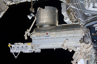
The Japan Aerospace Exploration Agency (JAXA) is the Japanese national air and space agency. Through the merger of three previously independent organizations, JAXA was formed on 1 October 2003. JAXA is responsible for research, technology development and launch of satellites into orbit, and is involved in many more advanced missions such as asteroid exploration and possible human exploration of the Moon. Its motto is One JAXA and its corporate slogan is Explore to Realize.

<span class="mw-page-title-main">Advanced Land Observation Satellite</span> Japanese Earth observation satellite

Advanced Land Observing Satellite (ALOS), also called Daichi, was a 3810 kg Japanese satellite launched in 2006. After five years of service, the satellite lost power and ceased communication with Earth, but remains in orbit.

Ajisai is a Japanese satellite sponsored by NASDA, launched in 1986 on the maiden flight of the H-I rocket. It is also known as the Experimental Geodetic Satellite (EGS), as it carries the Experimental Geodetic Payload (EGP).

<span class="mw-page-title-main">Greenhouse Gases Observing Satellite</span> Earth observation satellite

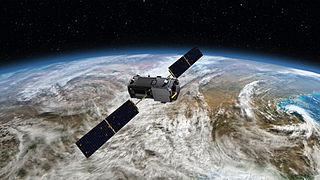
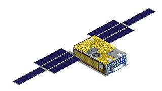
Greenhouse Gases Observing Satellite (GOSAT), also known as Ibuki, is an Earth observation satellite and the world's first satellite dedicated to greenhouse gas monitoring. It measures the densities of carbon dioxide and methane from 56,000 locations on the Earth's atmosphere. The GOSAT was developed by the Japan Aerospace Exploration Agency (JAXA) and launched on 23 January 2009, from the Tanegashima Space Center. Japan's Ministry of the Environment, and the National Institute for Environmental Studies (NIES) use the data to track gases causing the greenhouse effect, and share the data with NASA and other international scientific organizations.

<span class="mw-page-title-main">N-I (rocket)</span> Booster

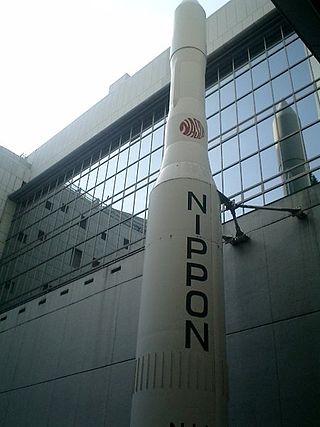
The N-I or N-1 was a derivative of the American Thor-Delta rocket, produced under license in Japan. The N stood for "Nippon" (Japan). It used a Long Tank Thor first stage, a Mitsubishi Heavy Industries-designed LE-3 engine on the second stage, and three Castor SRMs. Seven were launched between 1975 and 1982, before it was replaced by the N-II. Six of the seven launches were successful, however on the fifth flight, there was recontact between the satellite and the third stage, which caused the satellite to fail.

Marine Observation Satellite-1 (MOS-1), also known as Momo-1, was Japan's first Earth observation satellite. It was launched on 19 February 1987 on a N-II rocket from Tanegashima Space Center and was operated by the National Space Development Agency of Japan (NASDA). It is in a polar orbit at roughly 900 km altitude, but was decommissioned on 29 November 1995.

The Institute for Unmanned Space Experiment Free Flyer (USEF) (財団法人無人宇宙実験システム研究開発機構) was a Japanese space agency, which was founded by the Ministry of International Trade and Industry in 1986. Unlike NASDA, ISAS, and NAL, it was not included in the JAXA organization, which was founded in 2003. The chairperson is Ichiro Taniguchi.

<span class="mw-page-title-main">Greenhouse gas monitoring</span> Measurement of greenhouse gas emissions and levels

Greenhouse gas monitoring is the direct measurement of greenhouse gas emissions and levels. There are several different methods of measuring carbon dioxide concentrations in the atmosphere, including infrared analyzing and manometry. Methane and nitrous oxide are measured by other instruments. Greenhouse gases are measured from space such as by the Orbiting Carbon Observatory and networks of ground stations such as the Integrated Carbon Observation System.

<span class="mw-page-title-main">ADEOS II</span> Japanese Earth observation satellite

ADEOS II was an Earth observation satellite (EOS) launched by NASDA, with contributions from NASA and CNES, in December 2002. and it was the successor to the 1996 mission ADEOS I. The mission ended in October 2003 after the satellite's solar panels failed.

<span class="mw-page-title-main">ADEOS I</span> Japanese Earth observation satellite

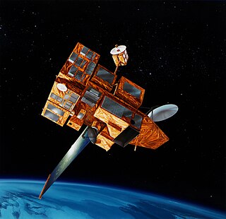
ADEOS I was an Earth observation satellite launched by NASDA in 1996. The mission's Japanese name, Midori means "green". The mission ended in July 1997 after the satellite sustained structural damage to the solar panel. Its successor, ADEOS II, was launched in 2002. Like the first mission, it ended after less than a year, also following solar panel malfunctions.

<span class="mw-page-title-main">Japanese space program</span> Space program of Japan

The Japanese space program originated in the mid-1950s as a research group led by Hideo Itokawa at the University of Tokyo. The size of the rockets produced gradually increased from under 30 cm (12 in) at the start of the project, to over 15 m (49 ft) by the mid-1960s. The aim of the original research project was to launch a man-made satellite.

The Alaska Satellite Facility is a data processing facility and satellite-tracking ground station within the Geophysical Institute at the University of Alaska Fairbanks. The facility’s mission is to make remote-sensing data accessible Its work is central to polar processes research including wetlands, glaciers, sea ice, climate change, permafrost, flooding and land cover such as changes in the Amazon rainforest.

<span class="mw-page-title-main">NISAR (satellite)</span> Joint NASA-ISRO synthetic radar aperture spacecraft

The NASA-ISRO Synthetic Aperture Radar (NISAR) mission is a joint project between NASA and ISRO to co-develop and launch a dual-frequency synthetic aperture radar on an Earth observation satellite. The satellite will be the first radar imaging satellite to use dual frequencies. It will be used for remote sensing, to observe and understand natural processes on Earth. For example, its left-facing instruments will study the Antarctic cryosphere. With a total cost estimated at US$1.5 billion, NISAR is likely to be the world's most expensive Earth-imaging satellite.

<span class="mw-page-title-main">Space-based measurements of carbon dioxide</span> Used to help answer questions about Earths carbon cycle

Space-based measurements of carbon dioxide are used to help answer questions about Earth's carbon cycle. There are a variety of active and planned instruments for measuring carbon dioxide in Earth's atmosphere from space. The first satellite mission designed to measure CO2 was the Interferometric Monitor for Greenhouse Gases (IMG) on board the ADEOS I satellite in 1996. This mission lasted less than a year. Since then, additional space-based measurements have begun, including those from two high-precision satellites. Different instrument designs may reflect different primary missions.

<span class="mw-page-title-main">Martian Moons eXploration</span> Planned sample-return mission by Japan to Phobos

Martian Moons eXploration (MMX) is a robotic space probe set for launch in 2026 to bring back the first samples from Mars' largest moon Phobos. Developed by the Japan Aerospace Exploration Agency (JAXA) and announced on 9 June 2015, MMX will land and collect samples from Phobos once or twice, along with conducting Deimos flyby observations and monitoring Mars's climate.

The Committee on Earth Observation Satellites (CEOS) is an international organization created in 1984 around the topic of Earth observation satellites.

The Greenhouse Gases Observing Satellite-2 (GOSAT-2), also known as Ibuki-2, is an Earth observation satellite dedicated to greenhouse gas monitoring. It is a successor of Greenhouse Gases Observing Satellite (GOSAT). The GOSAT-2 was developed as a joint project of the Japan Aerospace Exploration Agency (JAXA), Ministry of the Environment, and the National Institute for Environmental Studies (NIES). It was launched on 29 October 2018 from the Tanegashima Space Center aboard the H-IIA rocket.

References

  1. 1 2 3 Jane's Space Industry and Industry. "Earth Observation Center (EOC) (Japan)", IHS . 6 February 2003. Retrieved on 17 October 2012.
  2. Japanese Aerospace Exploration Agency. "Earth Observation Center" Archived 2012-06-14 at the Wayback Machine , February 2003. Retrieved on 17 October 2012.
  3. Japanese Aerospace Exploration Agency. "Introduction to EOC., February 2003. Retrieved on 20 October 2012.
  4. Japanese Aerospace Exploration Agency "First Thermal infrared spectra" Acquired by Onboard Sensors, 19 March 2009. Retrieved on 31 October 2012.
  5. Japanese Aerospace Exploration Agency "A new record minimum of the Arctic sea ice extent", 25 August 2012. Retrieved on 30 October 2012.
  6. Japanese Aerospace Exploration Agency "Wild fire in South California; Santa Ana Wind as a hidden main factor", 14 November 2007. Retrieved on 31 October 2012.
  7. Japanese Aerospace Exploration Agency "Severe Flood in Thailand", 25 April 2012. Retrieved on 31 October 2012.
  8. United States Geological Survey. "International Ground Station (IGS) Network", 17 October 2012. Retrieved on 17 October 2012.

36°00′11″N139°20′57″E / 36.00306°N 139.34917°E / 36.00306; 139.34917