Breckinridge County is a county located in the Commonwealth of Kentucky. As of the 2010 census, the population was 20,059. Its county seat is Hardinsburg, Kentucky. The county was named for John Breckinridge (1760–1806), a Kentucky Attorney General, state legislator, United States Senator, and United States Attorney General. It was the 38th Kentucky county in order of formation.

Hardin County is a county located in the U.S. state of Illinois. According to the 2010 census, it has a population of 4,320, making it the least populous county in Illinois. Its county seat is Elizabethtown. Hardin County is located in the part of the state known as Little Egypt. Hardin County was named for Hardin County, Kentucky, which was named in honor of Colonel John Hardin, an officer in the American Revolutionary War and the Northwest Indian War.
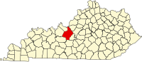
Hardinsburg is a home rule-class city in Breckinridge County, Kentucky, in the United States. It is the seat of its county. The population was 2,343 at the 2010 census. Hardinsburg was named after Captain William Hardin.

Radcliff is a home rule-class city in Hardin County, Kentucky, in the United States. The population was 21,692 at the 2010 census, and in 2016 the estimated population was 22,490. It is included in the Elizabethtown–Fort Knox Metropolitan Area.

Martin D. Hardin was a politician and lawyer from Kentucky. Born in Pennsylvania, his family immigrated to Kentucky when he was still young. He studied law under George Nicholas and commenced practice at Richmond, Kentucky. His cousin, future U.S. Representative Benjamin Hardin, studied in his law office. He represented Madison County in the Kentucky House of Representatives for a single term.
The Elizabethtown–Fort Knox Metropolitan Statistical Area, as defined by the United States Census Bureau, is an area consisting of two counties in Kentucky, anchored by the city of Elizabethtown and the nearby Fort Knox Army post. As of the 2000 census, the MSA had a population of 107,547.
McDaniels is an unincorporated community in Breckinridge County, Kentucky, United States. McDaniels is located along Kentucky Highway 259, 15.5 miles (24.9 km) due south of Hardinsburg. McDaniels is situated on Rough River Lake, which collects the 29.5-mile-long (47.5 km) North Fork Rough River, which flows for its entire length in Breckinridge County. McDaniels has a post office with ZIP code 42754.

Rineyville is an unincorporated community and census-designated place (CDP) in Hardin County, Kentucky, United States. It is located 7 miles (11 km) northwest of Elizabethtown, the county seat. The Paducah and Louisville Railway runs through the middle of town.
Big Spring, Kentucky is an unincorporated community in Breckinridge County, Meade County, and Hardin County in the U.S. state of Kentucky.
Limp is an unincorporated community in Hardin County, Kentucky, United States.
Eastview is an unincorporated community in Hardin County, Kentucky, United States.
White Mills is an unincorporated community in Hardin County, Kentucky, United States.
Nolin is an unincorporated community in Hardin County, Kentucky, United States. Nolin is located along a railroad 10 miles (16 km) south of Elizabethtown. The Nolin Banking Company, which is listed on the National Register of Historic Places, is located in Nolin.
Howevalley is an unincorporated community in Hardin County, Kentucky, United States. Howe Valley is located on Kentucky Route 86 12.3 miles (19.8 km) west of Elizabethtown.
Star Mills is an unincorporated community in Hardin County, Kentucky, United States. Star Mills is located on Kentucky Route 1375, 9.6 miles (15.4 km) southwest of Elizabethtown.
Hardin Springs is an unincorporated community in Hardin County, Kentucky, United States. Hardin Springs is located on Kentucky Route 84, 22.4 miles (36.0 km) west-southwest of Elizabethtown. The Hardin Springs School, which is listed on the National Register of Historic Places, is located in Hardin Springs.

St. Mary is a home rule-class city in Marion County, Kentucky, in the United States. During the 2010 U.S. Census, the Saint Mary Division of Marion Co. – covering 34.3 square miles (89 km2) around the city – had a population of 2,765.
Old Stephensburg is an unincorporated community in Hardin County, Kentucky, United States.