Related Research Articles
This article is about the Transport in Zambia.
Solwezi is a town in Zambia. It is the provincial capital of the mineral-rich North-Western Province. Solwezi is also the administrative capital of Solwezi District, one of the eleven districts in the North-Western Province.

Chingola is a city in Zambia's Copperbelt Province, the country's copper-mining region, with a population of 216,626. It is the home of Nchanga Copper Mine, a deep-shaft high-grade content copper mining operation, which subsequently led to the development of two open pit operations, Chingola Open Pit and then Nchanga Open Pit.

Ndola is the third largest city in Zambia and third in terms of size and population, with a population of 475,194, after the capital, Lusaka, and Kitwe, and the second largest in terms of infrastructure development after Lusaka. It is the industrial and commercial center of the Copperbelt, Zambia's copper-mining region, and capital of Copperbelt Province. It lies just 10 kilometres (6.2 mi) from the border with DR Congo. It is also home to Zambia's first modern stadium, the Levy Mwanawasa Stadium.

Copperbelt Province is a province in Zambia which covers the mineral-rich Copperbelt, and farming and bush areas to the south. It was the backbone of the Northern Rhodesian economy during British colonial rule and fuelled the hopes of the immediate post-independence period, but its economic importance was severely damaged by a crash in global copper prices in 1973. The province adjoins the Haut-Katanga province of the Democratic Republic of the Congo, which is similarly mineral-rich.

Kitwe is the third largest city in terms of infrastructure development and second largest city in terms of size and population in Zambia. With a population of 517,543 Kitwe is one of the most developed commercial and industrial areas in the nation, alongside Ndola and Lusaka. It has a complex of mines on its north-western and western edges.

Zambia Railways (ZR) is the national railway company of Zambia, one of the two major railway organisations in Zambia. The other system is the binational TAZARA Railway (TAZARA) that interconnects with the ZR at Kapiri Mposhi and provides a link to the Tanzanian port of Dar es Salaam.

Kapiri Mposhi is a Zambian town and the seat of the Kapiri Mposhi District in Central Province. Located north of Lusaka, it stands on the Great North Road and is significant for the railway connection between the Zambia Railways line from Kitwe to Lusaka and the western terminus of the Tanzania-Zambia Railway Authority from Dar es Salaam since 1976.
Mufulira is a town in the Copperbelt Province of Zambia. Mufulira means "Place of Abundance and Peace". The town developed around the Mufulira Copper Mine in the 1930s. The town also serves as the administrative capital of Mufulira District.
Mwinilunga is a town in the North-Western Province of Zambia. It is the headquarters of Mwinilunga District, one of the province's eleven districts.

The Copperbelt is a natural region in Central Africa which sits on the border region between northern Zambia and the southern Democratic Republic of Congo. It is known for copper mining.

The Tazama Pipeline, also Tanzania–Zambia Crude Oil Pipeline, is a 1,710 kilometres (1,063 mi) long crude oil pipeline from the port of Dar-es-Salaam, Tanzania, to the Indeni Petroleum Refinery in Ndola, Zambia.

The Congo Pedicle road crosses the Congolese territory of the Congo Pedicle and was constructed by and is maintained by Zambia to connect its Copperbelt and Luapula Provinces. Both the road and the territory may be referred to as ‘the Pedicle’. It is designated as the N36 Route on the Congolese Road Network.
This article gives lists of the National Monuments and other historic sites of Zambia, with a one- or two-line description providing links to details given on other pages.
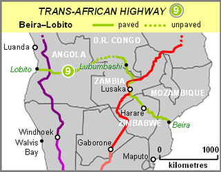
The Beira–Lobito Highway or TAH 9 is Trans-African Highway 9 in the transcontinental road network being developed by the United Nations Economic Commission for Africa (UNECA), the African Development Bank (ADB), and the African Union. The route has a length of 3,523 km (2,189 mi) crossing Angola, the most southerly part of the Democratic Republic of the Congo, Zambia, Zimbabwe, and central Mozambique.

The T2 is a trunk road in Zambia. The road runs from the Tunduma border with Tanzania via Mpika, Kabwe and Lusaka to the Chirundu border with Zimbabwe. The road is the longest route of the country, as it is approximately 1,155 kilometres (718 mi). The route from Mpika to Kafue is a toll road. The route from Tanzania to Lusaka is Zambia's Great North Road and is part of the Tanzam Highway.
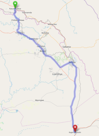
The T3 is a Trunk Road in Zambia. The road runs from Kapiri Mposhi via Ndola, Kitwe and Chingola to Kasumbalesa on the border with DR Congo. The entire route is a toll road.

Kafubu River is a river in the Copperbelt Province of Zambia. It starts in Ndola and it cuts through the city's main area westwards into the area in-between Levy Mwanawasa Stadium and Masala before turning southwards after Masala and continuing through the Luanshya and Masaiti districts to join the Kafue River.
Kasumbalesa is a town in Zambia that sits across the international border from the much larger town of Kasumbalesa, Democratic Republic of the Congo. It is a major crossing point for human traffic and cargo between the two countries.
The M4 road is a road in the Copperbelt Province of Zambia. The road connects the city of Ndola with the city of Mufulira and extends to connect Mufulira with the city of Kitwe. As it is a v-shaped route, the M4 road starts and ends at a junction with the T3 road.
References
- ↑ Vandenplas, A. (1947), La Température au Congo-Belge , Brussels: Ministère des Colonies, p. 143.
- ↑ "Frontier Project". 24hGold. Retrieved 2011-11-04.
12°45′S28°34′E / 12.75°S 28.56°E
| | This Democratic Republic of the Congo location article is a stub. You can help Wikipedia by expanding it. |