Álava or Araba, officially Araba/Álava, is a province of Spain and a historical territory of the Basque Country, heir of the ancient Lordship of Álava, former medieval Catholic bishopric and now Latin titular see.

Vitoria-Gasteiz, also alternatively spelled as Vittoria in old English-language sources, is the seat of government and the capital city of the Basque Country and of the province of Álava in northern Spain. It holds the autonomous community's House of Parliament, the headquarters of the Government, and the Lehendakari's official residency. The municipality—which comprises not only the city but also the mainly agricultural lands of 63 villages around—is the largest in the Basque Country, with a total area of 276.81 square kilometres (106.88 sq mi), and it has a population of 253,093. The dwellers of Vitoria-Gasteiz are called vitorianos or gasteiztarrak, while traditionally they are dubbed babazorros.

A wetland is a distinct ecosystem that is flooded or saturated by water, either permanently or seasonally. Flooding results in oxygen-free (anoxic) processes prevailing, especially in the soils. The primary factor that distinguishes wetlands from terrestrial land forms or water bodies is the characteristic vegetation of aquatic plants, adapted to the unique anoxic hydric soils. Wetlands are considered among the most biologically diverse of all ecosystems, serving as home to a wide range of plant and animal species. Methods for assessing wetland functions, wetland ecological health, and general wetland condition have been developed for many regions of the world. These methods have contributed to wetland conservation partly by raising public awareness of the functions some wetlands provide.

The University of Wisconsin–Madison Arboretum is a teaching and research facility of the University of Wisconsin–Madison and the site of historic research in ecological restoration. In addition to its 1,260 acres (5 km2) in Madison, Wisconsin, the Arboretum also manages 520 acres (210 ha) of remnant forests and prairies throughout Wisconsin. It was designated a National Historic Landmark in 2021, in recognition for its role as a pioneer in the field of ecological restoration.
Gornje Podunavlje Special Nature Reserve is a large protected area of wetland in the northwest of Serbia, on the Danube's left bank. It comprises two large marshes, Monoštorski Rit and Apatinski Rit and vast forests, meadows, ponds, swamps and the Danube's meanders, including 66 km (41 mi) of the Danube course. It is a part of the trans-boundary biosphere reserve "Mura-Drava-Danube", a five country project, dubbed the "Amazon of Europe".

The Basque Country, also called Basque Autonomous Community, is an autonomous community of Spain. It includes the provinces of Álava, Biscay, and Gipuzkoa, located in the north of the Iberian Peninsula, bordering on the autonomous communities of Cantabria, Castile and León, La Rioja, and Navarre, and the French region of Nouvelle-Aquitaine.
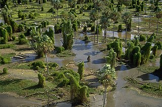
The Río Pilcomayo National Park is a national park located in the northeastern part of the Argentine province of Formosa, on the border with Paraguay. Established on September 29, 1951 to protect the natural features, typical of the Humid Chaco ecoregion, the park is included in the Ramsar Convention's list of wetlands of international importance.
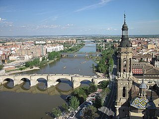
The Ebro is a river of the north and northeast of the Iberian Peninsula, in Spain. It rises in Cantabria and flows 930 kilometres (580 mi), almost entirely in an east southeast direction. It flows into the Mediterranean Sea forming a delta in the Province of Tarragona, in southern Catalonia. In the Iberian peninsula, it ranks second in length after the Tagus and second in discharge volume, and drainage basin, after the Douro. It is the longest river entirely within Spain; the other two mentioned flow into Portugal. It is also the second longest river in the Mediterranean basin, after the Nile.
The park of Armentia, commonly known as "El bosque de Armentia", is a gall-oak forest located between Vitoria-Gasteiz and the Mountains of Vitoria, in the province of Álava and of the autonomous community of the Basque Country in northern Spain. It has a surface area of 165 has and it is one of the main biological areas in the surroundings because it has a variety of flora and fauna.
The Green Belt of Vitoria-Gasteiz is a set of urban parks with high ecological value, strategically linked by eco-recreational corridors. It is the result of an ambitious plan of restoration and reclamation on the outskirts of the city that seeks to recover the ecological and social value of this space through the creation of a nature tour around the city articulated by various enclaves of high ecological value and landscape. It is the result of a project which began in the early 1990s and was selected by the UN among the 100 best global performances of the III International Competition "Best Practices for improving the living conditions of the cities", held in Dubai in the year 2000. Currently, it has five established parks: Armentia, Olarizu, Salburua, Zabalgana and Zadorra.

Chingaza National Natural Park is located in the Eastern Ranges of the Colombian Andes, northeast of Bogotá, Colombia in the departments of Cundinamarca and Meta. The elevation in the park, to the east of the Altiplano Cundiboyacense, ranges from 800 metres (2,600 ft) to 4,020 metres (13,190 ft), and the temperature ranges from 4 to 21.5 °C. The park extends over the Cundinamarca municipalities La Calera, Fómeque, Guasca and San Juanito (Meta).

Betoño is a village in Álava, Basque Country, Spain.
Tourism in the Basque Autonomous Community has increased considerably in recent years. According to data from the Eustat the number of tourists entering the region in the year 2009 was 1,991,790, with the final result still pending. 71% of the yearly visitors come from the rest of Spain; the greatest number from Madrid Autonomous Community (14.2%), and Catalonia (11.1%). International visitors make up the remaining 29% - the largest percent come from France (7.2%). 62% of the people who come to the Basque Autonomous Community visit one of the three capitals, 27% visit inland and 11% visit the coast. The average stay of the visitors is 2 days.
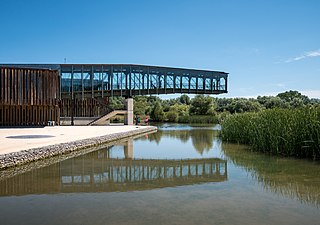
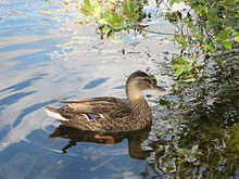
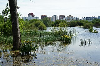
Ataria Interpretation Centre is a wetlands interpretation centre and natural history museum for the Salburua wetlands, a Ramsar site and a significant wetlands habitat in the Basque Autonomous Community. The wetlands region is an important green belt on the eastern outskirts of the city of Vitoria - Gasteiz in Álava-Araba province. Ataria showcases the value of the wetlands, which are classified as a class 1 Habitat of European Community Interest, and the importance of biodiversity to Vitoria-Gasteiz's natural heritage. The Salburua marshes are considered to be "the Basque country's most valuable area of wetland", according to a Fedenatur report for the European Commission in 2004.

Armentia is one of the villages associated with Vitoria-Gasteiz. Its name comes from the Latin word armentum, which translated into English means "intensive farming". The village is well known for its 161ha park created in the 1998.
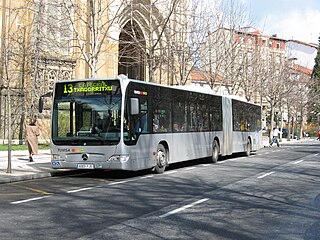
TUVISA is the municipal company responsible for urban transport in the city of Vitoria-Gasteiz, in the north of Spain. As of March 2022, the company operates 97 buses.

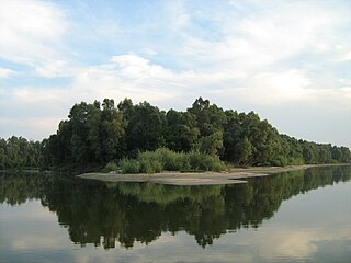
The Ullíbarri-Gamboa Reservoir (Basque: Uribarri Ganboako urtegia, Spanish: Embalse de Ullíbarri-Gamboa) is located in Álava, Basque Country, Spain. With a total capacity of 147.2 hm3 (5.20×10⁹ cu ft), it is the largest reservoir in the Basque Country. Together with the nearby Urrunaga Reservoir, it provides water to the nearby city of Vitoria-Gasteiz and to Bilbao and its metropolitan area. The whole reservoir has been designated as a Natura 2000 site, and the southeastern end of the reservoir is also protected as a Ramsar wetland. It is also a popular leisure area, particularly for hiking and bathing.
The Prespa National Park is a national park situated in southeastern Albania on the border triangle shared with Greece and North Macedonia. At approximately 277.5 km2 (107.1 sq mi), the park encompasses the country's sections of the Great and Small Prespa Lake. It is considerably characterised by high mountains, narrow islands, vast freshwater wetlands, salt marshes, meadows, reed beds and dense forests.
The Betoño Sports Complex, also known as El Glorioso, is a football training ground and match venue located in the city of Vitoria-Gasteiz, Álava.
The Ciudad Deportiva José Luis Compañón, also known as Instalaciones de Ibaia after the name of its semi-rural location, is the primary training ground of Spanish professional football club Deportivo Alavés, located in the city of Vitoria-Gasteiz, Álava.