Urdaibai estuary

Last updated
The Urdaibai estuary Mundaka.jpg
The Urdaibai estuary

The Urdaibai estuary is a natural region and a Biosphere Reserve of Biscay, Basque Country, Spain. It is also referred as Mundaka or Gernika estuary.

Contents

Urdaibai is located on the Bay of Biscay coast, in the north of the Iberian Peninsula. Urdaibai covers an area of 220 km2 (85 sq mi) with some 45,000 inhabitants, most of them concentrated in the towns of Bermeo and Gernika. The territory is characterized by a hydrographic basin of small streams that merge in a great salt marsh surrounded by high sheer cliffs. The surrounding countryside is occupied by meadowland, oak groves, leafy woods and specially by plantations of fast-growing conifers (Pinus radiata). The coastal landscape is covered with Cantabrian woods of Holm Oak and Strawberry Trees.

In Urdaibai have been described 615 species of vascular plants and 318 species of vertebrates, 245 of which are birds.

The area contains remnants of the Prehistoric, Roman and the Middle Ages. Particularly notable is the Santimamiñe cave, which has yielded archeological artifacts from the Mousterian (Middle Paleolithic Age) to the Iron Age.

The economy is based on metallurgy, fishing, farming and forestry. An important tourist sector is based on the quality of the local beaches. Mundaka is especially appealing for surfers around the world.

Description

The Oca river rises in the Oiz mountain and finishes in the Cantabric sea. The coast is rugged and with high cliffs and some islands, of which the most important is Izaro Island.

Izaro island Isla de Izaro.jpg
Izaro island

The development of forests reserves have allowed a degree of environmental conservation, which gives this area the most diverse landscape of the Basque Country.

Climate and temperature

The area of Urdaibai has an Atlantic climate, wet and warm and regulated by the sea (with temperature between 9-19 degrees C.) The annual rainfall is heavy; the rainiest months are November and December, although it is distributed during all the year. Precipitation is generally rain. Because of the influence of the sea, the temperature is moderate during the year (the average temperature is 13/14 degrees).

Landscape

Oka's marshes Urdaibai 5.JPG
Oka's marshes

The landscape is formed with mountains, sea and sands, which are produced by the sediments of the estuary, where marshes are flooded by the tides. The rivers Laga and Artigas go directly to the sea. The first ends in Laga's beach, and the second one creates a small valley between the Sollube mountain and Bermeo.

Estuary

The estuary, together with Santoña's natural park, is arguably the most important wetland in the Iberian Peninsula. The estuary is the heart of the Biosphere Reserve, which is a habitat for a wide variety of migratory and resident birds. As regards migrating birds, the attractions of the biosphere reserve, and in particular the Urdaibai Bird Center in Gautegiz Arteaga, are promoted to birdwatchers as part of the international "Bird Flyway" project. [1] [2]

The interior is defined by the mountains, and on their slopes are forest plantations of Monterey Pine used to make wood. There also are a few forests with local trees, such as Oak; and near the coast are plantations of Eucalyptus. On the central area, the land becomes flat and it is used in agriculture. This landscape is supported by livestock and agricultural development. The estuary extends from Guernica to Busturia, and a 5 km canal has been made in order not to dry up.

Mountains

The slopes of the mountains are covered by forests of Holm Oaks down to the sea's edge. The limestone nature of the bedrock has led to a kast system, where numerous caves and galleries may be found.

Coast

Laida's beach Mundaka.jpg
Laida's beach

To the north, at the mouth of the estuary, the sands of Sukarrieta and Laida line the shore of the Oka River.

To the west are the sands of Santa Katalina, Murgoa and Lamera. The Murgoa has a slope of a hundred meters, forming places like Trankilpunta and Kargaderua. After Bermeo are found the cliffs of Talape and Tonpoi. In the flysch that is made at the foot of the cliff can be found the " Arribolak", large stones which have been released from the wall and later rounded by the sea. To the east the sea stops being rough.

Flora and fauna

Protected areas

The biosphere reserve was designated in 1984. [3]

Flora

The flora that is developed in Urdabai, is clearly an atlantic base. There are a lot of meadows, oak groves, lush forests and especially plenty of Monterey pines. The coastal area is covered by cantabrian forests. The vegetable world that can be found here, is formed by 615 species of plants. Human activity has substantially modified the space, but the agricultural works have allowed the recuperation of original vegetation. The vegetation has, mainly in the marsh, a degree of singularity because of the specialization and also and its particular appearance. However, at the same time it has a high grade of diversity originated by the salinity. The area of Urdaibai is composed by different environments, each of which has its own vegetation and animals that create their own ecosystem.

Fauna

The big variety of ecosystems that can be found in the Urdaibai make possible the faunistic wealth, with 318 species of vertebrates, apart from the amount of different birds.

Geography

There are four distinct areas of interest in the reserve:

Geographically three distinct areas can be distinguished: The mountains, the marshes and the coast with its cliffs and beaches.

Human occupation

The population of the Busturialdea, which practically coincides with that of the protected Biosphere Reserve of Uradibai area is about 45,000 inhabitants are mainly located (80%), in the towns of Guernica Luno and Bermeo. Human presence has been ongoing in the area since prehistoric times, having testimonies based on findings from the Upper Paleolithic. Notable Roman remains, especially disrupted the necropolis with burials from the first century until the nineteenth century found in the church of San Martin de Tours of Forua.

The two largest centres of population are the municipalities of Bermeo and Guernica. Bermeo is a village founded in 1236 and one of the most important fishing ports of Biscay. It is the most populous town in the region and was the capital of the Lordship of Biscay from 1476 until 1602. Guernica is formed by the union of the historical town of Guernica with Porch of Luno. Guernica, founded in 1366, is the historical seat of the General Assembly of Vizcaya and it is the House of Meetings with Tree of Guernica, a symbol of Basque privileges. It is also famous worldwide for the bombing suffered in the Spanish Civil War of 1936, the subject of Picasso's painting 'Guernica'.

The remaining populations are small centers that cater to the historical political demarcation of the Lordship of Biscay in which the call Level Earth was organized porches. Mundaca and Elanchove are coastal populations, the first of which is at the mouth of the Oka. Both populations have a fishing origin although the current economic engine is tourism.

The village is the residential unit and farming and ranching in which has traditionally been the livelihood of the region of Busturialdea. This type of interaction between man and the environment has produced the landscape of Atlantic countryside which makes up much of the area of Urdaibai. Within the territory of the Urdaibai there is a great variety and richness of villages, all of them examples of rural Architecture and of great ethnographic value.

The economy is based on metallurgy, fishing, agriculture and forestry. There is also a tourism sector, focusing mainly on local beaches and natural values of the reserve. Mundaca is especially attractive for surfers from around the world.

Maps

Related Research Articles

Guernica City in Basque Country, Spain

Guernica, official name Gernika, is a town in the province of Biscay, in the Autonomous Community of the Basque Country, Spain. The town of Guernica is one part of the municipality of Gernika-Lumo (Spanish: Guernica y Luno, whose population is 16,224 as of 2009.
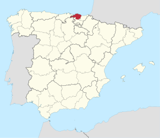
Biscay Province of Spain

Biscay is a province of Spain, lying on the south shore of the eponymous bay. The name also refers to a historical territory of the Basque Country, heir of the ancient Lordship of Biscay. Its capital city is Bilbao. It is one of the most prosperous and important provinces of Spain as a result of the substantial trading activity of its ports during and after the middle ages, becoming a strong commercial hub, and the massive industrialization during the last quarter of the 19th century and first half of the 20th century, creating one of Spain's largest industrial centers. Since the deep deindustrialization of the 1970s, the economy has come to rely more on the services sector.

UNESCO Biosphere Reserves are environment-protected scientific-research institutions of international status that are created with the intent for conservation in a natural state the most typical natural complexes of biosphere, conducting background ecological monitoring, studying of the surrounding natural environment, its changes under the activity of anthropogenic factors.

Bermeo Municipality in Basque Country, Spain

Bermeo is a town and municipality in the comarca of Busturialdea. It is in the province of Biscay, which is part of the autonomous region of the Basque Country in northern Spain.

Mundaka Municipality in Euskadi, Spain

Mundaka is a town and municipality located in the province of Biscay, in the autonomous community of Basque Country, northern Spain. On the coast, Mundaka is internationally renowned for its surfing scene.

The North Devon Coast was designated as an Area of Outstanding Natural Beauty in September 1959. The AONB contributes to a family of protected landscapes in the Southwest of England and a total of 38% of the region is classified by the International Union for Conservation of Nature as Category V Protected Landscapes. The twelve Areas of Outstanding Natural Beauty extend to 30% of the region, twice the proportion covered by AONBs in England as a whole and a further two National Parks, Dartmoor and Exmoor, cover an addition 7%. The North Devon Coast AONB covers 171 square kilometres (66 sq mi) of mainly coastal landscape from the border of Exmoor National Park at Combe Martin, through the mouth of the Taw & Torridge Estuary to the Cornish border at Marsland Mouth. The dune system at Braunton Burrows forms the core area of North Devon's Biosphere Reserve, the first "new style" Unesco-designated reserve in the United Kingdom. The whole of the AONB is within the Reserve boundaries.

Oiz Mountain summit in Biscay, Basque Country, Spain

Mount Oiz, is one of the most popular summits of Biscay in the Basque Country (Spain). Its summits form part of a long range that feeds several rivers: Ibaizabal, Artibai, Lea, Oka and Deba in Gipuzkoa all of them running to the Bay of Biscay.

Busturialdea Eskualdea / Comarca in Basque Country, Spain

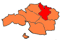
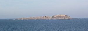
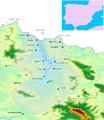
Busturialdea, also named Busturialde - Urdaibai is a comarca of the province of Biscay, in the Basque Country, Spain. It is the heir of "Busturia", one of the original merindades that used to compose the province of Biscay – this should not be confused with Busturia, a municipality located in this region. Busturialdea is a diminished portion of the same original subregion and has two capital cities; Bermeo and Gernika-Lumo. It is one of the seven comarcas that compose the province of Biscay.

The 3,848 acres (6.013 sq mi) Landels-Hill Big Creek Reserve located in the southern region of Big Sur, California is owned by the University of California Natural Reserve System. It is located off State Route 1 in 50 miles (80 km) south of Monterey and adjacent to the Big Creek State Marine Reserve and Big Creek State Marine Conservation Area. It is open to the general public one day a year.

Kamchia (biosphere reserve)

The Kamchia Biosphere Reserve, is a former UNESCO-listed biosphere reserve on the northern coastline of Bulgaria, comprising the floodplain at the mouth of the Kamchia River. Consisting largely of alluvial longose groves,, but also featuring some of the Black Sea coastline, the area of the protected habitats in the reserve, together with Kamchia Sands Protected Area, totals 1.200 ha. Established in 1977, it protects the primeval forest from the intensive logging and drainage that had decimated it by mid-20th century. It is situated 25 km south of the town of Varna and is enclosed by the villages of Staro Oriahovo, Shkorpilovtsi and Bliznatsi.

Under UNESCO’s Man and the Biosphere Programme, there are 302 biosphere reserves recognized as part of the World Network of Biosphere Reserves in Europe and North America. These are distributed across 36 countries in the region.

Physical geography of the Basque Country

The physical geography of the Basque Country is very diverse despite the small size of the region. The territory hosts a blend of green and brown to yellowish tones, featuring hilly terrain altogether. The Basque Country spreads from the rough coastal landscape to the semi-desert of the Bardenas on the south-eastern fringes of Navarre.

Tourism in the Basque Autonomous Community has increased considerably in recent years. According to data from the Eustat the number of tourists entering the region in the year 2009 was 1,991,790, a figure which has improved over 2010, with the final result still pending. Of the people who visit the region each year, 71% come from the rest of Spain, with the following Autonomous Communities providing the greatest number of visitors: Madrid Autonomous Community (14.2%), Catalonia (11.1%). International visitors make up the remaining 29%, with France (7.2%) being the country which provides the most visitors to the Basque Autonomous Community. Furthermore, 62% of the people who come to the Basque Autonomous Community visit one of the three capitals, 27% visit inland and 11% the Basque Autonomous Community coast. The average stay of the visitors is 1.88 days, with Gipuzkoa being the province which records the longest stays, with an average of 2.01 days.

Carpathian Biosphere Reserve

Carpathian Biosphere Reserve is a biosphere reserve that was established as a nature reserve in 1968 and became part of the World Network of Biosphere Reserves of UNESCO in 1992. Since 2007 bigger portion of the reserve along with some territories of the Uzh River National Park was listed with the UNESCO World Heritage Sites as part of the Ancient and Primeval Beech Forests of the Carpathians and Other Regions of Europe.

Wildlife of Ukraine

Wildlife of Ukraine includes its diverse fauna and flora. Ukraine contains six terrestrial ecoregions: Central European mixed forests, Crimean Submediterranean forest complex, East European forest steppe, Pannonian mixed forests, Carpathian montane conifer forests, and Pontic steppe. Ukraine is home to a diverse assemblage of animals, fungi, microorganisms and plants.The reported fauna includes forty-five thousand species including the areas of the Black Sea and the Sea of Azov. Protected areas consist of 33 Ramsar sites covering an area of 7,446.51 square kilometres (2,875.11 sq mi). Biosphere nature reserves and three national parks are all part of the GEF projects portfolio of conservation of biodiversity in the Danube Delta. Their vegetation pattern is Mixed Forest area, Forest-Steppe area, Steppe area, Ukrainian Carpathian Mountains and Crimean Mountains. Some of the protected areas which were reserves or parks are subsumed under the biosphere reserves.

The wildlife of Lebanon refers to the flora and fauna of Lebanon, a country in Asia located at the eastern end of the Mediterranean Sea. The country has four main geographical areas: the coastal plain, Mount Lebanon, the Beqaa Valley and the Anti-Lebanon Mountains. The climate is Mediterranean, with the coastal regions experiencing hot, humid summers and cool, wet winters, and the elevated areas inland experiencing colder winters with snow that lingers on into the summer. The country offers a variety of habitats for wildlife, including mountains, valleys, marshes, coastal plains, salt marshes and sea coasts.

Magaliesberg Biosphere Reserve Protected area in South Africa

The Magaliesberg Biosphere Reserve is located in South Africa between the cities of Pretoria and Johannesburg to the east and Rustenburg to the west. The reserve lies at the interface of two great African biomes — the Central Grassland Plateaux and the sub-Saharan savannah — and the remnants of a third biome, the Afro‐montane forest. The rich biodiversity includes floral species such as Aloe peglerae and Frithia pulchra, and faunal species such as the forest shrew, sable antelope and 443 bird species representing 46.6% of total bird species in the southern African sub-region.

Oka Nature Reserve

Oka Nature Reserve is a Russian 'zapovednik' located in the Meschera lowlands, the floodplain of the Oka River and the Pra River. With extensive lowland rivers and forested peatlands, the reserve is an important area for waterfowl and waders. The reserve hosts breeding centers for bison and for crane. The site is situated in the Spassky District, Ryazan Oblast, about 60 km northeast of the city of Ryazan. In 1994, the "Flood plains of Rivers Pra and Oka" was designated a Ramsar wetland of international importance. The site was designated a UNESCO Man and Biosphere (MAB) reserve in 1978. The reserve was formally established in 1935, and covers an area of 55,722 ha (215.14 sq mi).

The Brighton and Lewes Downs Biosphere Reserve is a UNESCO Biosphere Reserve located in Sussex on the southeast coast of England near the city of Brighton and Hove. Forming a central unit of the hills of the South Downs National Park, it is centred on the Brighton chalk block that lies between the River Adur in the west and the River Ouse in the east. Chalk downland makes up the principal terrestrial landscape of the area, bounded at each end by the two river valleys. The coastline is dominated by impressive chalk cliffs in the east and urbanized plains in the west, running to the estuary of the River Adur at Shoreham-by-Sea. The area is nationally and internationally renowned for its arts and culture, distinctive settlements, independent mindset and its links to the surrounding iconic English landscape of downland, white chalk cliffs and beaches.

Urdaibai Bird Center Place

Urdaibai Bird Center is a nature museum. It provides an excellent observation point from which visitors can enjoy the world of birds and their migratory journeys. It is located in the heart of the Urdaibai Biosphere Reserve in Vizcaya, Basque Country (Spain)
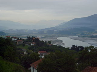
References

  1. What is BirdFlyway?
  2. Urdaibai Bird Center
  3. "UNESCO - MAB Biosphere Reserves Directory". www.unesco.org. Archived from the original on 2007-10-24.
  4. Scottish ospreys...

Coordinates: 43°19′56″N2°40′19″W / 43.33222°N 2.67194°W / 43.33222; -2.67194