Salt Plains National Wildlife Refuge

Last updated

Salt Plains National Wildlife Refuge
IUCN category IV (habitat/species management area)
Salt Plains of Oklahoma.jpg
The Salt Plains near the Crystal digging area
USA Oklahoma relief location map.svg
Red pog.svg
Salt Plains
Usa edcp relief location map.png
Red pog.svg
Salt Plains
Location Alfalfa County, Oklahoma
Nearest city Jet
Coordinates 36°45′01″N98°13′27″W / 36.750314°N 98.224259°W / 36.750314; -98.224259
Area32,080 acres (129.8 km2)
Established1930
Governing body United States Fish and Wildlife Service
Website Salt Plains National Wildlife Refuge
DesignatedJune 1983

The Salt Plains National Wildlife Refuge is part of the United States system of national wildlife refuges. It is located in Alfalfa County in northern Oklahoma, north of Jet (pop. 230), along Great Salt Plains Lake, which is formed by a dam on the Salt Fork of the Arkansas River.

Contents

The refuge was established March 26, 1930, by executive order of President Herbert Hoover, and contains 32,080 acres (130 km2) of protected land as habitat to about 312 species of birds and 30 species of mammals. It was designated a national natural landmark in June 1983. [1]

A map of the Salt Plains National Wildlife Refuge Salt plains NWR.jpg
A map of the Salt Plains National Wildlife Refuge

Refuge description

The Salt Plains were a favorite hunting ground for American Indians. Bison and other game came to the area to eat the salt and the heavily wooded and well-watered area along the Salt Fork River was like an oasis in the surrounding grassland of the Great Plains. Salt Plains refuge is divided into almost equal areas of nonvegetated salt flat, open water, and vegetated land. Marshes, woods, grasslands, and croplands dot the refuge. Management tools used to enhance the habitat for wildlife include farming, grazing, prescribed burns, construction of ponds, and wetland draining and flooding. [2]

The refuge was created to be a resting and breeding ground for migratory waterfowl especially during fall and spring. The entire refuge is designated as critical habitat for the endangered whooping crane, which is mostly seen during fall migration. [3] In addition, the refuge is home to endangered least terns, threatened snowy plovers, threatened bald eagles, and peregrine falcons. Large populations of American white pelicans migrate through between August and September, staying on the Great Salt Plains Reservoir. Great Salt Plains is one of the most important habitats for shorebirds in the Western Hemisphere. [4]

Ralstin Island

Ralstin Island (closed to the public) is an important rookery in the Great Salt Plains Lake. The island was originally 25 acres (100,000 m2), but has eroded to about 6 acres (20,000 m2). [5] It hosts more than 30,000 birds during breeding season. Over 30 species nest in the colony, including the white-faced ibis, great blue herons, and most notably, the tricolored heron.

History of the Great Salt Plains

Osage control of Great Salt Plains

According to Historian Louis F. Burns, the Osage Indians used the salt found in the Great Salt Plains to bleach deer-skins and the Great Salt Plains gave the Osages a surplus of salt to trade with other tribes. According to Burns, the Osage were firmly in control of the Great Salt Plains by 1760 and because of a favorable combination of geographical factors, the Osages became the dominant force in mid—America. "In a one hundred twenty-five year period, 1678-1803, the Osages performed a feat no other American Indians duplicated," writes Burns. "They stopped the west-ward expansion of the Euro-American peoples and simultaneously tripled the size of their own domain." [6]

Sibley Expedition

George Champlin Sibley was appointed head trader at the Indian Factory at Fort Osage, Missouri, when it opened in 1808. While at Fort Osage, Sibley quickly engaged in creating relationships with the neighboring Osage tribes. In May 1811 Sibley's expedition left Fort Osage to examine the hunting grounds of the Osage. In 1811 his expedition was said to be the first white men to visit the plains. Sibley's expedition, leaving from Fort Osage, Missouri was guided by an Osage Indian named Sans Orielle. Sibley named the area the Grand Saline. Sibley cut short his expedition when informed by reports that bands of Comanche were nearby. Sibley returned to Fort Osage on July 11, 1811 and reported that the salt deposits would eventually prove commercially profitable. [7] [8] [9]

Native American usage

The Great Salt Plains have been the scene of many Indian Councils, both of war and peace. Because animals flocked to the area for the salt, the Great Salt Plains made for excellent hunting and it became obvious that any tribe that controlled the Salt Plains would have to contend with intrusions by other tribes. Therefore the Treaty of New Echota signed in 1835, provided the Cherokee Nation with ownership of the Cherokee Outlet but declared that the saline areas were to be accessible to use by other tribes. In drafting the treaty the United States Government withheld the Salt Plains area with the provision that, "The right is reserved to the United States to allow other tribes of red men to get salt on the Great Salt Plains in common with the Cherokee Tribe." [7] [8] [9]

Chemical weapons discovery

In 2007, a Boy Scout digging for crystals uncovered a collection of 7.5-inch vials containing chemical agents such as mustard gas, lewisite, chloropicrin, and phosgene. [10] [11] The vials were part of World War II-era military chemical agent identification sets. [10] The burial of vials was standard procedure for removing them from service at that time. No record of a disposal site was reported at the salt plains. Crystal digging was suspended from April 2007 until April 2009, while the risk of allowing digging again was evaluated; 171 vials and at least a dozen incendiary devices were removed from the location. [10] [12] The salt plains were also used as a bombing and strafing range during World War II. [13] Remnants of this use are still left on the plains. [14]

Recreation

A wet day at Crystal digging area of the Salt Plains Salt Plains National Wildlife Refuge Oklahoma.jpg
A wet day at Crystal digging area of the Salt Plains

Driving tour: The Harold F. Miller Auto Tour begins near the nature center. It is 2.5 miles (4 km) long and ends at Highway 11. The dirt road passes by ponds and fields where crops for wildlife are cultivated. White-tailed deer and other wildlife are common. A trail of 0.25 miles (400 m) leads to Casey Marsh Tower, where waterfowl are abundant and bald eagles can be seen in fall and winter. [15]

Hiking: The Sandpiper Trail begins near the nature center and refuge office and leads 0.35 miles (600 m) to the edge of the salt flats and a birding observation platform. The Eagle Roost Nature Trail is a 1.25-mile (2.0 km) loop also beginning near the nature center. The trail goes through wooded and open areas, beneath towering cottonwood trees, past marshes and ponds, and to a shore and waterfowl watching area on Sand Creek Bay. [15]

Selenite crystals: A designated area of the 11,000 acres (45 km2) of salt flats at the refuge has gypsum concentrations high enough to grow selenite, a crystalline form of gypsum. The selenite crystals found there have an hourglass-shaped sand inclusion that is not known to occur in selenite crystals found elsewhere in the world. [16] Digging for crystals is allowed, but only from April 1 through October 15 to protect this vital Whooping Crane habitat. [17]

Hunting: About 1,250 acres (5 km2) of the refuge north of Highway 11 are open for hunting. State laws apply, except deer may be hunted by permit only. Hunting is permitted for pheasant, northern bobwhite quail, mourning dove, ducks, geese, and sandhill cranes. [18]

Fishing: According to the U.S. Army Corps of Engineers, the extreme drought of 2011 and 2012 has almost ended fishing as a recreational activity at the refuge. These conditions caused very large fish kills in the reservoir and restocking has been suspended. Fishing downstream of the dam is still permitted, but is greatly affected by local precipitation and the flow of the Great Salt River. [19]

Information that follows indicate the practices in force prior to the 2011 drought, and may no longer apply: Fishing is permitted from April 1 to October 15 on most of the refuge. Closed areas are marked by buoys or signs. Fishing in Bonham Pond is permitted only for children under 14 and mobility-handicapped persons and is catch-and-release. Salt Plains Lake is noted for large channel and other catfish. Other game fish include striped bass, largemouth bass, crappie, white bass, panfish, and walleye. State laws apply for bag limits and seasons, and the use of boats in the river and creeks is prohibited. [20]

See also

Related Research Articles

<span class="mw-page-title-main">Bald Knob National Wildlife Refuge</span>

The Bald Knob National Wildlife Refuge is a 15,022 acres (60.79 km2) (2014) wildlife refuge located in White County, Arkansas about two miles south of the town of Bald Knob. The refuge is managed by the United States Fish and Wildlife Service. The refuge features large numbers of migratory waterfowl and bald eagles during the winter months.

<span class="mw-page-title-main">Merritt Island National Wildlife Refuge</span> Protected area in Florida, US

Merritt Island National Wildlife Refuge is a 140,000 acres (57,000 ha) U.S. National Wildlife Refuge (NWR) on the Atlantic coast of Florida's largest barrier island. NASA's Kennedy Space Center and visitor complex are also situated on the island and NASA can restrict access to the refuge based on its operational needs.

<span class="mw-page-title-main">Quivira National Wildlife Refuge</span> Wildlife refuge in Kansas, United States

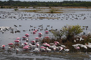
Quivira National Wildlife Refuge in south central Kansas, United States, includes rare inland marshes. Located near the town of Stafford, it lies mostly in northeastern Stafford County, but small parts extend into southwestern Rice and northwestern Reno Counties. Its proximity to the Central Flyway migration route and the salt marshes on the refuge combine to endow the refuge with a large variety of birds. Many of these birds are uncommon in other parts of Kansas or even the central part of the continent.

<span class="mw-page-title-main">Great Salt Plains Lake</span> Reservoir in Alfalfa County, Oklahoma

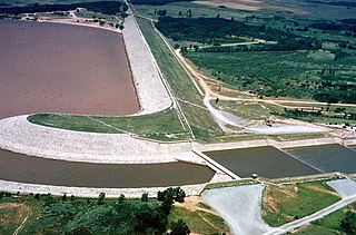
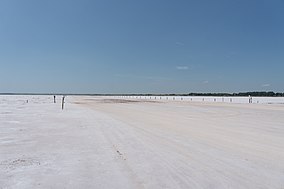
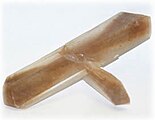
Great Salt Plains Lake is a reservoir located within the Salt Plains National Wildlife Refuge in Alfalfa County, Oklahoma in the United States named because of the salt flats in the area and for the Salt Fork Arkansas River, which is dammed to form the lake. It is notable for the variety of birds that are attracted to Ralstin Island and also for the selenite crystals that can be collected along the shoreline. Recent droughts, most notably that of 2011, have had an adverse effect on the future of the lake.

<span class="mw-page-title-main">Loxahatchee National Wildlife Refuge</span> United States National Wildlife Refuge in Florida

The Arthur R. Marshall Loxahatchee National Wildlife Refuge is a 145,188-acre (587.55 km2) wildlife sanctuary is located west of Boynton Beach, in Palm Beach County, Florida. It is also known as Water Conservation Area 1 (WCA-1). It includes the most northern remnant of the historic Everglades wetland ecosystem.

<span class="mw-page-title-main">Erie National Wildlife Refuge</span>

The Erie National Wildlife Refuge is an 8,777-acre (3,552 ha) National Wildlife Refuge located in Crawford County, Pennsylvania. Named after the Erie tribe, it was established to provide waterfowl and other migratory birds with nesting, feeding, brooding, and resting habitat.

<span class="mw-page-title-main">Mingo National Wildlife Refuge</span>

The Mingo National Wildlife Refuge is a 21,676-acre (87.7-km2) National Wildlife Refuge located in northwestern Stoddard and southeastern Wayne counties in Missouri. Its southwesternmost portion lies on the shores of Lake Wappapello. Named after the Mingo tribe, it was established to preserve bottomland hardwoods and provide waterfowl and other migratory birds in the Mississippi Flyway with nesting, feeding, brooding, and resting habitat.

<span class="mw-page-title-main">Arrowwood National Wildlife Refuge</span> Protected area in North Dakota, US

Arrowwood National Wildlife Refuge is located in the U.S. state of North Dakota. Arrowwood NWR is a part of the Arrowwood National Wildlife Refuge Complex, and is managed by the U.S. Fish and Wildlife Service. The refuge parallels 16 miles (27 km) of the James River and is a mixture of wetlands, forest and prairie. Efforts to ensure the refuge continues to provide prime nesting habitat for waterfowl include prescribed fire, haying, crop cultivation and livestock grazing. The refuge has forests with oak and hackberry which are uncommon on the prairie. It is believed that the name for the refuge is derived from Native American naming for arrow wood, as the wood in the forest was prized for the making of arrows.

<span class="mw-page-title-main">Baskett Slough National Wildlife Refuge</span>

Baskett Slough National Wildlife Refuge is in northwestern Oregon, 10 miles (16 km) west of Salem in Polk County. The Refuge consists of 1,173 acres (4.75 km²) of cropland, which provide forage for wintering geese, 300 acres (1.2 km²) of forests, 550 acres (2.2 km²) of grasslands, and 500 acres (2.0 km²) of shallow water seasonal wetlands and 35 acres (0.14 km²) of permanent open water. In 1965, Baskett Slough National Wildlife Refuge was created to help ensure some of the original habitat remained for species preservation. The refuge is managed by the U.S. Fish and Wildlife Service, an agency of the U.S. Department of the Interior.

The Rydell National Wildlife Refuge is an 2,120-acre (9 km2) National Wildlife Refuge in northwestern Minnesota, located in Woodside Township, Polk County, just west of Erskine in northwestern Minnesota. It was established in 1992, and receives more than 7,800 visitors each year. The refuge is a combination of maple/basswood/oak forest, wetlands, tallgrass prairie and bogs.

<span class="mw-page-title-main">Lake Ilo National Wildlife Refuge</span> Wildlife refuge

Lake Ilo National Wildlife Refuge (NWR) is located in the U.S. state of North Dakota and is managed from Audubon National Wildlife Refuge by the U.S. Fish and Wildlife Service. The refuge consists of Lake Ilo, surrounding wetlands and some upland range, providing habitat for hundreds of species of birds, and numerous fish and mammal species. An average of over 16 inches (40 cm) of precipitation falls annually, supporting a prairie ecosystem.

The Des Lacs National Wildlife Refuge is located in the U.S. state of North Dakota and extends from the Canada–United States border to near the town of Kenmare, North Dakota along Des Lacs Lake. The refuge was established in 1935 and includes 19,500 acres (78.9 km2). The refuge is considered to be one of the most important bird sanctuaries in the U.S., with tens of thousands of birds using the refuge for migration and breeding. The refuge is also home to elk, moose, bison and pronghorn.

<span class="mw-page-title-main">Hart Mountain National Antelope Refuge</span> National Wildlife Refuge in Oregon, U.S.

Hart Mountain National Antelope Refuge is a National Wildlife Refuge on Hart Mountain in southeastern Oregon, which protects more than 422 square miles (1,090 km2) and more than 300 species of wildlife, including pronghorn, bighorn sheep, mule deer, sage grouse, and Great Basin redband trout. The refuge, created in 1936 as a range for remnant herds of pronghorn, spans habitats ranging from high desert to shallow playa lakes, and is among the largest wildlife habitats containing no domestic livestock.

<span class="mw-page-title-main">Great Salt Plains State Park</span> State park in Oklahoma, United States

Great Salt Plains State Park is a 840-acre (3.4 km2) Oklahoma state park located in Alfalfa County, Oklahoma. It is located 8 miles (13 km) north of Jet, Oklahoma on SH-38 and 12 miles (19 km) east of Cherokee. Recreational opportunities at Great Salt Plains State Park include boating, camping, picnicking, swimming, hiking, mountain biking and exploring. The Great Salt Plains Lake is located at the park and covers 9,300 acres (38 km2) with 41 miles (66 km) of shoreline and is a shallow, salty lake with fishing opportunities for catfish, saugeye, sandbass and hybrid striper. The average depth is reportedly 4 feet (1.2 m) and the impoundment capacity is 31,420 acre-feet. Salinity of the water in the reservoir is one-fourth that of sea water. Personal watercraft are not recommended. The park has RV and tent sites, comfort stations with showers, cabins, picnic sites, group shelters, swimming beach, playgrounds, boat ramps, fishing dock and equestrian trails. Horse rental is not available.

<span class="mw-page-title-main">Eastern Neck National Wildlife Refuge</span>

Eastern Neck National Wildlife Refuge, a part of the Chesapeake Marshlands National Wildlife Refuge Complex, is a 2,286-acre (9.25 km2) island located at the confluence of the Chester River and the Chesapeake Bay. Established in 1962 as a sanctuary for migratory birds, Eastern Neck National Wildlife Refuge provides natural habitat for over 240 bird species — including bald eagles and transitory peregrine falcons — and is a major staging site for tundra swans.

<span class="mw-page-title-main">Parker River National Wildlife Refuge</span>

Parker River National Wildlife Refuge is a wildlife sanctuary encompassing the majority of Plum Island in northeastern Essex County, Massachusetts, 5 miles southeast of Newburyport. It was established in 1942 primarily to provide feeding, resting, and nesting habitats for migratory birds. Located along the Atlantic Flyway, the refuge is of vital stopover significance to waterfowl, shorebirds, and songbirds during migratory periods.

<span class="mw-page-title-main">Hagerman National Wildlife Refuge</span> Nature reserve in northwestern Grayson County, Texas, United States

Hagerman National Wildlife Refuge (HNWR), a haven for migratory birds and other wildlife, lies in northwestern Grayson County, Texas, on the Big Mineral Arm of Lake Texoma, on the Red River between Oklahoma and Texas. This National Wildlife Refuge is made up of water, marsh, and upland habitat. Visitors can hike, observe wildlife, hunt, and fish throughout the year.

<span class="mw-page-title-main">Summer Lake Wildlife Area</span> Wildlife refuge in Oregon

The Summer Lake Wildlife Area is a 29.6-square-mile (77 km2) wildlife refuge located on the northwestern edge of the Great Basin drainage in south-central Oregon. It is administered by the Oregon Department of Fish and Wildlife. The refuge is an important stop for waterfowl traveling along the Pacific Flyway during their spring and fall migrations. The Summer Lake Wildlife Area also provides habitat for shorebirds and other bird species as well as wide variety of mammals and several fish species. The Ana River supplies the water for the refuge wetlands.

<span class="mw-page-title-main">Eden Landing Ecological Reserve</span> Nature reserve in Hayward and Union City, California

Eden Landing Ecological Reserve is a nature reserve in Hayward and Union City, California, on the eastern shore of San Francisco Bay. The reserve is managed by the California Department of Fish and Game and comprises 5,040 acres of former industrial salt ponds now used as a low salinity waterbird habitat.

Nescatunga is an unincorporated census-designated place (CDP) in Alfalfa County, Oklahoma, United States adjacent to Great Salt Plains State Park. The population was 70 as of the 2010 census.

References

  1. "National Natural Landmarks - National Natural Landmarks (U.S. National Park Service)". www.nps.gov. Retrieved March 26, 2019. Year designated: 1983
  2. Salt Plains - Brochures
  3. Salt Plains - Welcome
  4. "List of Sites". www.whsrn.org. Western Hemisphere Shorebird Reserve Network. Archived from the original on July 29, 2010. Retrieved June 7, 2023.
  5. U.S. Fish and Wildlife Service. "Salt Plains National Wildlife Refuge." Retrieved April 20, 2013.
  6. The History of the Osage" by Louis F. Burns. ISBN   9780817350185
  7. 1 2 Corps of Engineers. "History of Great Salt Plains Lake" retrieved May 25, 2021
  8. 1 2 Oklahoma Historical Society. "GREAT SALT PLAINS" retrieved May 25, 2021.
  9. 1 2 Oklahoma Historical Society. "Sibley Expeditions" retrieved May 25, 2021.
  10. 1 2 3 "Crystal dig to open Saturday", Enid News & Eagle, April 18, 2009
  11. Fitzgerald, Scott, "Salt Plains beds yield 130-plus chemical vials", Enid News & Eagle, May 1, 2007
  12. Fitzgerald, Scott, "Incendiary devices found near chemicals at Salt Plains dig area", Enid News & Eagle, May 4, 2007
  13. Barron, Robert, "Officials speculate chemical at Salt Plains could be mustard gas", Enid News & Eagle, April 26, 2007
  14. "Scout unearths chemical; Salt Plains crystal beds under guard, are off-limits to public", Enid News & Eagle, April 24, 2007
  15. 1 2 "Salt Plains NWR Nature Trails". Archived from the original on February 6, 2007.
  16. "Salt Plains - Selenite Crystals". U.S. Fish & Wildlife Service. Retrieved May 9, 2016.
  17. "Salt Plains - Crystal Digging". U.S. Fish & Wildlife Service. Retrieved May 9, 2016.
  18. Hunting at Salt Plains
  19. US Army Corps of Engineers:Great Salt Plains Recreation. "Great Salt Plains Lake." Accessed April 20, 2015.
  20. Fishing at Salt Plains

PD-icon.svg This article incorporates public domain material from websites or documents of the United States Fish and Wildlife Service .

Informational videos

Official Great Salt Plains videos have been created and are hosted on YouTube. They are part of a short series, which includes: