San Antonio, Quezon

Last updated
San Antonio
Buliran
Municipality of San Antonio
SanAntonioQuezonjf0237 29.JPG
SanAntonio,Quezonjf172 11.JPG
SanAntonio,QuezonHalljf 0128 03.JPG
SanAntonioQuezonjf0237 06.JPG
Date of Published= April 16, 2017
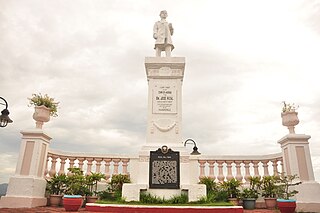
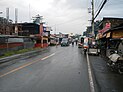
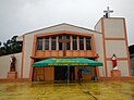
From top, left to right: Downtown area, Sacred Heart of Jesus Parish Church, Municipal Hall, Maria Amparo K. Dimayuga Park and Library
Flag of San Antonio, Quezon.png
Official Seal of San Antonio, Quezon.png
Ph locator quezon san antonio.png
Map of Quezon with San Antonio highlighted
OpenStreetMap
San Antonio, Quezon
Philippines location map (square).svg
Red pog.svg
San Antonio
Location within the Philippines
Coordinates: 13°54′N121°18′E / 13.9°N 121.3°E / 13.9; 121.3
Country Philippines
Region Calabarzon
Province Quezon
District 2nd district
Founded October 4, 1957
Named for St. Anthony of Padua
Barangays 20 (see Barangays)
Government
[1]
  Type Sangguniang Bayan
   Mayor Aniano Ariel Wagan Jr.
   Vice Mayor Jennifer H. Murphy
   Representative David C. Suarez
   Municipal Council
Members
   Electorate 24,411 voters (2022)
Area
[2]
  Total172.93 km2 (66.77 sq mi)
Elevation
134 m (440 ft)
Highest elevation
985 m (3,232 ft)
Lowest elevation
16 m (52 ft)
Population
 (2020 census) [3]
  Total35,891
  Density210/km2 (540/sq mi)
   Households
8,251
Demonym San Antoniohin
Economy
   Income class 4th municipal income class
   Poverty incidence
16.50
% (2018) [4]
   Revenue 121.4 million (2020)
   Assets 362.9 million (2020)
   Expenditure 100.2 million (2020)
   Liabilities 138 million (2020)
Service provider
  ElectricityManila Electric Company (Meralco)
Time zone UTC+8 (PST)
ZIP code
4324
PSGC
IDD : area code +63(0)42
Native languages Tagalog
Website www.sanantonio-quezon.webs.com

San Antonio, officially the Municipality of San Antonio (Tagalog : Bayan ng San Antonio), is a 4th class municipality in the province of Quezon, Philippines. According to the 2020 census, it has a population of 35,891 people. [3]

Contents

Located in the westernmost part of the province, it is one of the municipalities that traverses Quezon and Batangas. It has an efficient road system, the National Road linking Tiaong, Quezon and Lipa City through passing Padre Garcia. San Antonio is 45 kilometres (28 mi) from Lucena and 105 kilometres (65 mi) from Manila.

San Antonio is then known as Buliran, one of the progressive and component barangay of Tiaong, Quezon covered with thick cogon grasses and Buri trees. It is situated in the western part of Tiaong, its mother municipality, and bounded on the south by the Municipalities of Padre Garcia and Rosario in Batangas. Its history was known through the knowledge of many of its residents. Considering its abundance and economic opportunity, the place was occupied by the Batangueño from the western part of the barrio and became the pioneers and witnessed the pristine beauty of the place and later in cultivated and tilled its virgin and fertile land. [5]

It produces bottled Sinturis Juice, pasteurized freshly squeezed Philippine orange mixed with sugar, Malagkit Festival with the different kakanin made from malagkit. It also has several resorts and leisure farms that serve as favorite getaways for fun and family get together.

It is composed of 20 barangays, each headed by a barangay captain and seven councilmen duly elected. It is a third-class municipality having total area of 5,400 hectares (13,000 acres).

History

Buliran, a barangay of the present-day municipality of San Antonio, is a progressive one at its western part. Its history is still unknown to many people, which were told by two aged persons by the name of Mrs. Hermogina Quizon and Mr. Venancio Ilagan. According to them this barrio was named Bulihan. When they inhabited the place, they found the place a big area and crowded with tall cogon, talahib and amorsiko grasses, wild vines and giant-like trees along the river. The first people to inhabit the place were from the western part of the place or Batangueño who witnessed the wild animals loitering around. They were also the inhabitants who cultivated the land in spite of the fear they feel when this barrio was inhabited by the outlaws headed by Kolas Igat. [5]

This place which was the hideout of the out - laws was named to belong to "Impierno," which literally translates to hell, based on the killings of the prisoners of Kolas lgat. Kolas Igat and his men frequented the municipalities of San Pablo, Tiaong, Candelaria, San Juan, Padre Garcia and those who did not obey his orders were made prisoners and sentenced to death at "Impierno". Because of the many lives seized by the outlaw leader, the place was called "Buliran". [5]

Then under the administration of Kapitan Pedro Veneracion during the Spanish Regime, he distributed the land to the people. To allure the Batangueños, a road leading to Padre Garcia and Tiaong was opened. Every person who received a piece of land was asked to pay a tax of one peso or to donate free labor for one week in the construction of the road. As expected, the population grew fast and the people established residence along the road. Simeon de Torres, a barrio ruler, was among the inhabitants who have done a lot towards the attainment of peace and prosperity of the place. [5]

Time passed until 1938 when the barrio market was established through the kindness of Mr. Valentin Umali who lent the market site. A bridge was constructed between Niing and Buliran. A school building was constructed also, so with the first Catholic Chapel. In the year 1946, General Andres "Dumas" Umali thought of making Buliran a municipality separate from Tiaong. There were many hindrances as a result of the World War II. Time goes by and the barrio progressed. The barrio lieutenants then of Niing, Buliran, Pury, Behia, Callejon and Matipunso held a meeting and resolved to bring the matter to the Municipal Council of Tiaong through the Municipal Councilor, Juanito C. Wagan. The municipal council did not approve, however, the resolution. The insistent municipal councilor, then thought of approaching the congressman of the first district of Quezon, Manuel S. Enverga. He was advised to prepare a petition and brought it to the attention of the provincial board. The parish priest Calixto Jamilla, who was among the petitioner, choose the name San Antonio after St. Anthony of Padua because of the miracles he had shown. [5]

At Lucena, objections were raised. A public hearing was set at the Municipal Hall of Tiaong. The matter was fully deliberated upon, and the reasons for its creation were found satisfactory. The petition then was elevated to the Executive Secretary. [5]

Years passed, President Carlos P. Garcia signed Executive Order No. 270 on October 4, 1957, creating the new municipality of San Antonio. [6] On November 19, 1957, a municipal mayor, a vice mayor and six councilmen were appointed and took their oaths of office on November 22. The first municipal council session was held on November 25. [5]

Geography

Barangays

San Antonio is politically subdivided into 20 barangays. Each barangay consists of puroks and some have sitios.

  • Arawan
  • Bagong Niing
  • Balat Atis
  • Briones
  • Bulihan
  • Buliran
  • Callejon
  • Corazon
  • Del Valle
  • Loob
  • Magsaysay
  • Matipunso
  • Niing
  • Poblacion
  • Pulo
  • Pury
  • Sampaga
  • Sampaguita
  • San Jose
  • Sinturisan

Climate

Climate data for San Antonio, Quezon
MonthJanFebMarAprMayJunJulAugSepOctNovDecYear
Mean daily maximum °C (°F)27
(81)
28
(82)
29
(84)
31
(88)
31
(88)
30
(86)
29
(84)
29
(84)
29
(84)
28
(82)
28
(82)
27
(81)
29
(84)
Mean daily minimum °C (°F)20
(68)
20
(68)
21
(70)
22
(72)
24
(75)
24
(75)
24
(75)
24
(75)
23
(73)
23
(73)
22
(72)
21
(70)
22
(72)
Average precipitation mm (inches)52
(2.0)
35
(1.4)
27
(1.1)
27
(1.1)
82
(3.2)
124
(4.9)
163
(6.4)
144
(5.7)
145
(5.7)
141
(5.6)
100
(3.9)
102
(4.0)
1,142
(45)
Average rainy days12.08.18.89.717.922.626.224.524.622.016.714.9208
Source: Meteoblue [7]

Demographics

Population census of San Antonio
YearPop.±% p.a.
1960 9,847    
1970 14,236+3.75%
1975 16,204+2.63%
1980 17,701+1.78%
1990 20,786+1.62%
1995 22,933+1.86%
2000 26,419+3.08%
2007 30,023+1.78%
2010 31,681+1.98%
2015 33,467+1.05%
2020 35,891+1.38%
Source: Philippine Statistics Authority [8] [9] [10] [11]

Economy

Poverty Incidence of San Antonio

5
10
15
20
25
30
2006
15.80
2009
16.68
2012
24.03
2015
19.24
2018
16.50
2021
17.76

Source: Philippine Statistics Authority [12] [13] [14] [15] [16] [17] [18] [19]

Education

Preschool

  • Bixby Knolls Preparatory Academy, Inc.

Elementary

  • Anne Benedictine Montessori
  • Arawan Elementary School
  • Briones Elementary School
  • Bixby Knolls Preparatory Academy, Inc.
  • Bulihan Elementary School
  • Callejon Elementary School
  • Del Valle Elementary School
  • Domingo M. Isabedra MES (Loob ES)
  • Magsaysay Elementary School
  • Matipunso Elementary School
  • Niing Elementary School
  • Pury Elementary School
  • Saint Anne Montessori Learning Center
  • Sampaga Elementary School
  • San Antonio Central School
  • Sintorisan Elementary School
  • San Antonio Infotech School

Secondary

Tertiary

Tourism

Resorts

Government

Local government

San Antonio Municipal Hall SanAntonio,QuezonHalljf 0128 02.JPG
San Antonio Municipal Hall
Elected Officials of San Antonio (2022–present) [21] [22]
PositionNameParty
MayorAniano Ariel Wagan Jr. Nacionalista
Vice MayorJennifer Murphy NPC
Councilors
Mario Guce Nacionalista
Eddie Stallo Jr. NPC
Ryan Vidal Nacionalista
Manolito Pentinio Nacionalista
Petronilo Tapire Nacionalista
HedilitaMasongsong Nacionalista
Edna Perez Nacionalista
Cesar Dimaano Nacionalista

Notable personalities

Related Research Articles

<span class="mw-page-title-main">Pagbilao</span> Municipality in Quezon, Philippines

Pagbilao, officially the Municipality of Pagbilao, is a 1st class municipality in the province of Quezon, Philippines. According to the 2020 census, it has a population of 78,700 people.

<span class="mw-page-title-main">Candelaria, Quezon</span> Municipality in Quezon, Philippines

Candelaria, officially the Municipality of Candelaria, is a 1st class municipality in the province of Quezon, Philippines. According to the 2020 census, it has a population of 137,881 people.

<span class="mw-page-title-main">Teresa, Rizal</span> Municipality in Rizal, Philippines

Teresa, officially the Municipality of Teresa, is a 2nd class municipality in the province of Rizal, Philippines. According to the 2020 census, it has a population of 64,072 people.

<span class="mw-page-title-main">Talisay, Batangas</span> Municipality in Batangas, Philippines

Talisay, officially the Municipality of Talisay, is a 3rd class municipality in the province of Batangas, Philippines. According to the 2020 census, it has a population of 46,238 people.

<span class="mw-page-title-main">San Pascual, Batangas</span> Municipality in Batangas, Philippines

San Pascual, officially the Municipality of San Pascual, is a 1st class municipality in the province of Batangas, Philippines. According to the 2020 census, it has a population of 69,009 making it as the 9th most populous municipality in the province.

<span class="mw-page-title-main">Bauan</span> Municipality in Batangas, Philippines

Bauan, officially the Municipality of Bauan, is a 1st class municipality in the province of Batangas, Philippines. According to the 2020 census, it has a population of 90,819 people.

<span class="mw-page-title-main">Ibaan</span> Municipality in Batangas, Philippines

Ibaan, officially the Municipality of Ibaan, is a 2nd class municipality in the province of Batangas, Philippines. According to the 2020 census, it has a population of 58,507 people.

<span class="mw-page-title-main">Lemery, Batangas</span> Municipality in Batangas, Philippines

Lemery, officially the Municipality of Lemery, is a 1st class municipality in the province of Batangas, Philippines. According to the 2020 census, it has a population of 93,186 people.

<span class="mw-page-title-main">Mataasnakahoy</span> Municipality in Batangas, Philippines

Mataasnakahoy, officially the Municipality of Mataasnakahoy, is a 4th class municipality in the province of Batangas, Philippines. According to the 2020 census, it has a population of 30,621 people.

<span class="mw-page-title-main">San Juan, Batangas</span> Municipality in Batangas, Philippines

San Juan, officially the Municipality of San Juan, is a 1st class municipality in the province of Batangas, Philippines. According to the 2020 census, it has a population of 114,068 people.

<span class="mw-page-title-main">Santa Teresita, Batangas</span> Municipality in Batangas, Philippines

Santa Teresita, officially the Municipality of Santa Teresita, is a 5th class municipality in the province of Batangas, Philippines. According to the 2020 census, it has a population of 21,559 people.

<span class="mw-page-title-main">Guinayangan</span> Municipality in Quezon, Philippines

Guinayangan, officially the Municipality of Guinayangan, is a 3rd class municipality in the province of Quezon, Philippines. According to the 2020 census, it has a population of 44,045 people.

<span class="mw-page-title-main">Lucban</span> Municipality in Quezon, Philippines

Lucban, officially the Municipality of Lucban, is a 2nd class municipality in the province of Quezon, Philippines. According to the 2020 census, it has a population of 53,091 people.

<span class="mw-page-title-main">Mauban</span> Municipality in Quezon, Philippines

Mauban, officially the Municipality of Mauban, is a 1st class municipality in the province of Quezon, Philippines. According to the 2020 census, it has a population of 71,081 people.

<span class="mw-page-title-main">Pitogo, Quezon</span> Municipality in Quezon, Philippines

Pitogo, officially the Municipality of Pitogo, is a 4th class municipality in the province of Quezon, Philippines. According to the 2020 census, it has a population of 22,798 people.

<span class="mw-page-title-main">Sampaloc, Quezon</span> Municipality in Quezon, Philippines

Sampaloc, officially the Municipality of Sampaloc, is a 5th class municipality in the province of Quezon, Philippines. According to the 2020 census, it has a population of 13,629 people.

<span class="mw-page-title-main">San Andres, Quezon</span> Municipality in Quezon, Philippines

San Andres, officially the Municipality of San Andres, is a 4th class municipality in the province of Quezon, Philippines. According to the 2020 census, it has a population of 37,454 people.

<span class="mw-page-title-main">Tagkawayan</span> Municipality in Quezon, Philippines

Tagkawayan, officially the Municipality of Tagkawayan, is a 1st class municipality in the province of Quezon, Philippines. According to the 2020 census, it has a population of 54,003 people.

<span class="mw-page-title-main">Tiaong</span> Municipality in Quezon, Philippines

Tiaong, officially the Municipality of Tiaong, is a first-class municipality in the province of Quezon, Philippines. According to the 2020 census, it has a population of 106,265 people.

<span class="mw-page-title-main">Unisan, Quezon</span> Municipality in Quezon, Philippines

Unisan, officially the Municipality of Unisan, is a 4th class municipality in the province of Quezon, Philippines. According to the 2020 census, it has a population of 25,448 people.

References

  1. Municipality of San Antonio | (DILG)
  2. "2015 Census of Population, Report No. 3 – Population, Land Area, and Population Density" (PDF). Philippine Statistics Authority. Quezon City, Philippines. August 2016. ISSN   0117-1453. Archived (PDF) from the original on May 25, 2021. Retrieved July 16, 2021.
  3. 1 2 Census of Population (2020). "Region IV-A (Calabarzon)". Total Population by Province, City, Municipality and Barangay. Philippine Statistics Authority . Retrieved 8 July 2021.
  4. "PSA Releases the 2018 Municipal and City Level Poverty Estimates". Philippine Statistics Authority. 15 December 2021. Retrieved 22 January 2022.
  5. 1 2 3 4 5 6 7 "History of San Antonio, Quezon". San Antonio, Quezon. Retrieved 2015-11-22.
  6. Executive Order No. 270 (4 October 1957), Creating the Municipality of San Antonio in the Province of Quezon , retrieved January 5, 2022
  7. "San Antonio: Average Temperatures and Rainfall". Meteoblue. Retrieved 27 January 2020.
  8. Census of Population (2015). "Region IV-A (Calabarzon)". Total Population by Province, City, Municipality and Barangay. Philippine Statistics Authority . Retrieved 20 June 2016.
  9. Census of Population and Housing (2010). "Region IV-A (Calabarzon)" (PDF). Total Population by Province, City, Municipality and Barangay. National Statistics Office . Retrieved 29 June 2016.
  10. Censuses of Population (1903–2007). "Region IV-A (Calabarzon)". Table 1. Population Enumerated in Various Censuses by Province/Highly Urbanized City: 1903 to 2007. National Statistics Office.{{cite encyclopedia}}: CS1 maint: numeric names: authors list (link)
  11. "Province of Quezon". Municipality Population Data. Local Water Utilities Administration Research Division. Retrieved 17 December 2016.
  12. "Poverty incidence (PI):". Philippine Statistics Authority. Retrieved December 28, 2020.
  13. "Estimation of Local Poverty in the Philippines" (PDF). Philippine Statistics Authority. 29 November 2005.
  14. "2003 City and Municipal Level Poverty Estimates" (PDF). Philippine Statistics Authority. 23 March 2009.
  15. "City and Municipal Level Poverty Estimates; 2006 and 2009" (PDF). Philippine Statistics Authority. 3 August 2012.
  16. "2012 Municipal and City Level Poverty Estimates" (PDF). Philippine Statistics Authority. 31 May 2016.
  17. "Municipal and City Level Small Area Poverty Estimates; 2009, 2012 and 2015". Philippine Statistics Authority. 10 July 2019.
  18. "PSA Releases the 2018 Municipal and City Level Poverty Estimates". Philippine Statistics Authority. 15 December 2021. Retrieved 22 January 2022.
  19. "PSA Releases the 2021 City and Municipal Level Poverty Estimates". Philippine Statistics Authority. 2 April 2024. Retrieved 28 April 2024.
  20. ICT-ED Institute of Science and Technology
  21. "2022 ELECTION RESULTS: San Antonio, Quezon". Rappler . Retrieved January 7, 2023.
  22. "Elected Officials of San Antonio". DILG.