San Juan City, Colorado

Last updated
San Juan City
Extinct settlement
USA Colorado location map.svg
Red pog.svg
San Juan City
Now Freemon's Guest Ranch [lower-alpha 1]
Coordinates: 37°45′57″N107°6′44″W / 37.76583°N 107.11222°W / 37.76583; -107.11222
CountryUnited States
StateColorado
County Mineral
Nearest town Creede

San Juan City was designated the county seat of Hinsdale County, Colorado when the county was established on February 10, 1874. [1] [2] On February 23, 1875, voters decided to move the county seat to Lake City. [1] The town began as a mining camp, with the goal to become a hub for transportation of supplies to area mines. After a year as the county seat, it became a stage stop, offering food and lodging. It operated as a stage stop, post office, and roadhouse into the 1880s. In 1893, San Juan City became part of Mineral County, Colorado. A post office operated out of San Juan City, off and on, until 1923. The town's site, located along Clear Creek, is now Freemon's Guest Ranch. San Juan Ranch is also said to be the former site of San Juan City, but the former Galloway's transportion hub that became San Juan Ranch was located a few miles away from the town.

Contents

Mining camp and stage station

Before it was named a county seat, a settler named Franklin platted the town of San Juan City. [1] The first cabin, built by Capt. W. H. Green, was the courthouse for the county until voters elected to move the county seat to Lake City. [3] From 1874 to 1876, San Juan City had one merchant in a log cabin who operated mail service that was transported twice a week on a passenger and mail stage on the Alamosa to Silverton stage road. [1] [4] It was the county's first post office. [4] The town began as a mining camp, [1] and operated as such into the 1870s. [5] Town occupants intended San Juan City to be a supply town for miners, but most of the residents moved away from the town after Lake City was established. [6] In 1875, a stone hotel, restaurant, and post office was established by Ada (Dollie, Dolly) and Clarence Brooks. At that time, there were abandoned log cabins in the town. [7] Dolly ran the roadhouse, stage stop, and post office after she and Clarence divorced in the 1880s. [8]

External image
Searchtool.svg Early travelers on the Barlow and Sanderson Stage Route

Barlow and Sanderson Stage lines operated a stage line to San Juan City, transporting freight to the town. From there, freight was transported to remote areas across toll roads [4] on the backs of pack animals. [3] The freight business operated until 1882 when the Denver and Rio Grande Western Railroad made the stage line obsolete. [3] By 1884, the roadhouse was called Texas Club, and later Freemon's Guest Ranch. [9] [10] After September 1887, Dolly was no longer in the area, either because she left the area or died. [8]

The post office was moved three miles to Galloway's in 1877. [11] San Juan City had a post office intermittently until 1923. [12] In 1893, San Juan City became part of Mineral County, Colorado. [1]

Ranch

Two places have been identified as the site of the former San Juan City. The key distinction appears to be the different neighboring creeks and the distance from Creede. [1] [3] [4]

San Juan City has been reported to be approximately 20 miles (32 km) from Creede near the headwaters of the Rio Grande [1] at the mouth of Clear Creek. [13] A map in Roadside history of Colorado shows it west of Creede. [14] The two ranches are Freemon's Guest Ranch and San Juan Ranch, both sites were stops on the Barlow and Sanderson Stagecoach Line that operated between Del Norte, Lake City, and Silverton. [8]

According to Haunted Creede:

Both stops were considered part of Antelope Park. [8]

Freemon's Guest Ranch (formerly San Juan City)

External image
Searchtool.svg Freemon's Guest Ranch

San Juan City is now Freemon's Guest Ranch, which is 17 miles (27 km) from Creede [3] [7] and alongside Clear Creek, east of the confluence with the Rio Grande. [15] [lower-alpha 2] It was purchased by Ken Ellison in 1968. [8]

San Juan Ranch (formerly Galloways)

San Juan Ranch, a private property on US Forest Road 520, is located just west of Colorado Highway 149. [16] San Juan Ranch is 21.2 miles from Creede on Colorado Highway 149 and just north of Crooked Creek a bit further north of the Rio Grande. [17] [lower-alpha 4]

Notes

  1. San Juan City is not in the GNIS database. The coordinates are for Freemon's Guest Ranch or Store.
  2. The source says that "San Juan City was located... near the confluence of Crooked Creek and the Rio Grande", [3] but according to Google maps Freemon's Guest Ranch is alongside Clear Creek and near where it flows into the Rio Grande. [15]
  3. A source states that log cabin from the original town sits on San Juan Ranch, [4] but that may be due to the confusion of the San Juan City and Galloway sites. Eberhart states that there are no remnants of the town remaining at the site of the former San Juan City. [5]
  4. In the description of the San Juan Ranch site, in 1905, the site was purchased by the Officer family, who operated a resort and cattle ranch on the land. [4] The Officer family sold the property in 1960. [4] [lower-alpha 3]

Related Research Articles

<span class="mw-page-title-main">San Luis Valley</span> High-altitude basin in Colorado and New Mexico in the United States

The San Luis Valley is a region in south-central Colorado with a small portion overlapping into New Mexico. The valley is approximately 122 miles (196 km) long and 74 miles (119 km) wide, extending from the Continental Divide on the northwest rim into New Mexico on the south. It contains 6 counties and portions of 3 others. It is an extensive high-elevation depositional basin of approximately 8,000 square miles (21,000 km2) with an average elevation of 7,664 feet (2,336 m) above sea level. The valley is a section of the Rio Grande Rift and is drained to the south by the Rio Grande, which rises in the San Juan Mountains to the west of the valley and flows south into New Mexico. The San Luis Valley has a cold desert climate but has substantial water resources from the Rio Grande and groundwater.

<span class="mw-page-title-main">San Juan Mountains</span> Mountain range in Colorado and New Mexico, United States

The San Juan Mountains is a high and rugged mountain range in the Rocky Mountains in southwestern Colorado and northwestern New Mexico. The area is highly mineralized and figured in the gold and silver mining industry of early Colorado. Major towns, all old mining camps, include Creede, Lake City, Silverton, Ouray, and Telluride. Large scale mining has ended in the region, although independent prospectors still work claims throughout the range. The last large-scale mines were the Sunnyside Mine near Silverton, which operated until late in the 20th century, and the Idarado Mine on Red Mountain Pass, which closed in the 1970s. Famous old San Juan mines include the Camp Bird and Smuggler Union mines, both located between Telluride and Ouray.

<span class="mw-page-title-main">Denver and Rio Grande Western Railroad</span> American railroad company

The Denver and Rio Grande Western Railroad, often shortened to Rio Grande, D&RG or D&RGW, formerly the Denver & Rio Grande Railroad, was an American Class I railroad company. The railroad started as a 3 ft narrow-gauge line running south from Denver, Colorado, in 1870. It served mainly as a transcontinental bridge line between Denver and Salt Lake City, Utah. The Rio Grande was also a major origin of coal and mineral traffic.

<span class="mw-page-title-main">San Juan County, Colorado</span> County in Colorado, United States

San Juan County is a county located in the U.S. state of Colorado. As of the 2020 census, the population was 705, making it the least populous county in Colorado. The county seat and the only incorporated municipality in the county is Silverton. The county name is the Spanish language name for "Saint John", the name Spanish explorers gave to a river and the mountain range in the area. With a mean elevation of 11,240 feet, San Juan County is the highest county in the United States and also has the two highest elevation houses in the United States; the ‘Bonnie Belle’ above Animas Forks at 11,900’ – 11,950’ elevation and an unnamed house above Picayune Gulch at 12,000’ elevation.

<span class="mw-page-title-main">Mineral County, Colorado</span> County in Colorado, United States

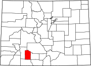
Mineral County is a county located in the U.S. state of Colorado. As of the 2020 census, the population was 865, making it the third-least populous county in Colorado, behind San Juan County and Hinsdale County. The county seat and only incorporated municipality in the county is Creede. The county was named for the many valuable minerals found in the mountains and streams of the area.

<span class="mw-page-title-main">Durango, Colorado</span> City in Colorado, United States

Durango is a home rule municipality that is the county seat and the most populous municipality of La Plata County, Colorado, United States. The city population was 19,071 at the 2020 United States Census. Durango is the home of Fort Lewis College.

<span class="mw-page-title-main">Creede, Colorado</span> Town in Mineral County, Colorado, United States

Creede is a Statutory Town and the county seat of Mineral County, Colorado, United States. It is the most populous community and the only incorporated municipality within the county. The town population was 257 at the 2020 United States census.

<span class="mw-page-title-main">Del Norte, Colorado</span> Statutory Town in Colorado, United States

Del Norte is a Statutory Town that is the county seat of Rio Grande County, Colorado, United States. The town's name is most commonly pronounced /ˈdɛl nɔɹt/. The town population was 1,458 at the 2020 United States Census.

<span class="mw-page-title-main">South Fork, Colorado</span> Town in Colorado, United States

South Fork is a statutory town in Rio Grande County, Colorado, United States. It lies at the confluence of the South Fork and Rio Grande rivers. The population was 510 at the 2020 census.

<span class="mw-page-title-main">Silverton, Colorado</span> The only incorporated Town and county seat of San Juan County, Colorado, United States

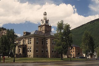
Silverton is a statutory town that is the county seat, the most populous community, and the only incorporated municipality in San Juan County, Colorado, United States. The town is located in a remote part of the western San Juan Mountains, a range of the Rocky Mountains. The first mining claims were made in mountains above the Silverton in 1860, near the end of the Colorado Gold Rush and when the land was still controlled by the Utes. Silverton was established shortly after the Utes ceded the region in the 1873 Brunot Agreement, and the town boomed from silver mining until the Panic of 1893 led to a collapse of the silver market, and boomed again from gold mining until the recession caused by the Panic of 1907. The entire town is included as a federally designated National Historic Landmark District, the Silverton Historic District.

The San Juan Skyway Scenic and Historic Byway is a 236-mile (380 km) All-American Road, National Forest Scenic Byway, and Colorado Scenic and Historic Byway located in Dolores, La Plata, Montezuma, San Juan, and San Miguel counties, Colorado, United States. The byway forms a loop in southwestern Colorado traversing the heart of the San Juan Mountains. The San Juan Skyway reaches its zenith at Red Mountain Pass at elevation 11,018 feet (3,358 m). Mesa Verde National Park was one of the original UNESCO World Heritage Sites. The Silverton Historic District and the Telluride Historic District are National Historic Landmarks.

<span class="mw-page-title-main">Rio Grande Southern Railroad</span> Former narrow-gauge railway in Colorado, US

The Rio Grande Southern Railroad was a 3 ft (914 mm) narrow-gauge railroad which ran in the southwestern region of the US state of Colorado, from the towns of Durango to Ridgway, routed via Lizard Head Pass. Built by Russian immigrant and Colorado toll road builder Otto Mears, the RGS operated from 1891 through 1951 and was built with the intent to transport immense amounts of silver mineral traffic that were being produced by the mining communities of Rico and Telluride. On both ends of the railroad, there were interchanges with The Denver and Rio Grande Railroad, which would ship the traffic the RGS hauled elsewhere like the San Juan Smelter in Durango.

<span class="mw-page-title-main">National Register of Historic Places listings in Colorado</span> List of National Register of Historic Places in the U.S. State of Colorado

There are more than 1,500 properties and historic districts in the U.S. State of Colorado listed on the National Register of Historic Places. They are distributed over 63 of Colorado's 64 counties; only the City and County of Broomfield currently has none.

<span class="mw-page-title-main">Weminuche Wilderness</span> Protected area in southwestern Colorado, US

The Weminuche Wilderness is a wilderness area in southwest Colorado managed by the United States Forest Service as part of the San Juan National Forest on the west side of the Continental Divide and the Rio Grande National Forest on the east side of the divide. The Weminuche Wilderness was designated by Congress in 1975, and expanded by the Colorado Wilderness Acts of 1980 and 1993. It is located 4 miles (6.4 km) southeast of the town of Silverton, 17 miles (27 km) northeast of Durango, and 8 miles (13 km) west of South Fork. At 499,771 acres (2,022.50 km2), it is the largest wilderness area in the state of Colorado. Elevation in the wilderness ranges from 7,700 feet (2,300 m) along the Animas River to 14,093 feet (4,296 m) at the summit of Windom Peak.

<span class="mw-page-title-main">Needleton, Colorado</span> Unincorporated community in San Juan County, Colorado, United States

Needleton is an ghost town in San Juan County, Colorado, United States. Its elevation is 8,277 feet (2,523 m).

<span class="mw-page-title-main">Howardsville, Colorado</span> Unincorporated community in San Miguel County, Colorado, United States

Howardsville is an unincorporated community in San Juan County, Colorado, United States, along the Animas River at the mouth of Cunningham Creek. Its elevation is 9,748 feet (2,971 m). It is located about two miles from the town of Silverton and 8 miles from the famous ghost town of Animas Forks, and is on the same road as the ghost towns of Middleton and Eureka.

<span class="mw-page-title-main">Colorado State Highway 149</span> State highway in Colorado, United States

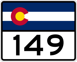
State Highway 149 (SH 149) is a 117.522-mile-long (189.133 km) state highway in southwestern Colorado, United States. SH 149's southern terminus is at U.S. Highway 160 (US 160) in South Fork, and the northern terminus is at US 50 west of Gunnison. The entire route is also known as the Silver Thread Scenic and Historic Byway.

<span class="mw-page-title-main">Alamosa–Durango line</span> Historic railroad line

The Alamosa–Durango line or San Juan extension was a railroad line built by the Denver and Rio Grande Western Railroad, following the border between the U.S. states of Colorado and New Mexico, in the Rocky Mountains. The line was originally built as a 3 ft narrow-gauge line between Alamosa, Colorado, and Durango, Colorado. Portions of the route survive: the now standard-gauged segment from Alamosa to Antonito, Colorado, and a narrow-gauge portion from Antonito to Chama, New Mexico.

References

  1. 1 2 3 4 5 6 7 8 Griswold, Don; Griswold, Jean (1958). Colorado's Century of "Cities". pp. 119–120.
  2. United States Indian Claims Commission (1978). Indian Claims Commission Decisions. Native American Rights Fund. p. 189.
  3. 1 2 3 4 5 6 7 Jessen, Kenneth (2018-06-02). "County seat San Juan City became a guest ranch" . Retrieved 2024-03-06.
  4. 1 2 3 4 5 6 7 8 "San Juan City". silverthreadbyway.com. Retrieved 2024-03-06.
  5. 1 2 Eberhart, Perry (1969). Guide to the Colorado ghost towns and mining camps. Chicago: Sage Books. ISBN   978-0-8040-0140-3.
  6. "Hinsdate County". Silver World. May 22, 1880. Retrieved 2024-03-06 via Colorado Historic Newspapers Collection.
  7. 1 2 Wagner, Sandra; Wetherill, Carol Ann (2017). Hidden History of the Upper Rio Grande. Arcadia Publishing. pp. 162–163. ISBN   978-1-4671-3717-1. The principal stops on the road to Silverton are San Juan City [modern-day Freemon's Ranch], 6 miles, where C.W. Brooks keeps a ranch and stopping place.
  8. 1 2 3 4 5 6 7 Payne, Kandra (2020). "What Lies Beneath". Haunted Creede. Arcadia Publishing. pp. 25–27, 29. ISBN   978-1-4671-4455-1.
  9. Jacobs, Janis of Creede Historical Society (2017-06-20). "Creede: A Very Brief History". Creede and Mineral County Visitor Guide - Creede, Colorado by Creede & Mineral County Chamber of Commerce. p. 9 via Issuu.
  10. "4 Must-Do Adventures in the Upper Rio Grande". Lake City - A Peak Experience. December 20, 2022. Retrieved 2024-03-07.
  11. "Notes from the Rio Grande: San Juan post office". The Colorado Daily Chieftain. July 7, 1877. Retrieved 2024-03-06 via Colorado Historic Newspapers Collection.
  12. Elliott, Donald R. (1999). Doris L. (Salmen) Elliott (ed.). "Place names of Colorado" (PDF). history.denverlibrary.org. p. 540.
  13. Rohrabacher, R. Copeland (1901). The great San Juan of Colorado and New Mexico : a brief history of the early days supplemented by a review of the vast natural resources of the San Juan country. Durango, Colo. : Durango Democrat. p. 4.
  14. McTighe, James (1989). Roadside history of Colorado. Boulder, Colo. : Johnson Books. p. 240. ISBN   978-1-55566-054-3.
  15. 1 2 "37°45'57.0"N 107°06'44.0"W · 39284 CO-149, Creede, CO 81130". 37°45'57.0"N 107°06'44.0"W · 39284 CO-149, Creede, CO 81130. Retrieved 2024-03-06.
  16. "San Juan Ranch". www.creede.com. Retrieved 2024-03-06.
  17. "Creede to San Juan Ranch". Google maps. Retrieved 2024-03-06.