
San Juan County is a county in the southeastern portion of the U.S. state of Utah. As of the 2010 United States Census, the population was 14,746. Its county seat is Monticello, while its most populous city is Blanding. The county was named by the Utah State Legislature for the San Juan River, itself named by Spanish explorers.

Apache County is located in the northeast corner of the U.S. state of Arizona. As of the 2010 census its population was 71,518. The county seat is St. Johns.

The City of Cortez is the home rule municipality that is the county seat and the most populous municipality of Montezuma County, Colorado, United States. The city population was 8,766 at the 2020 United States Census.

Aneth is a census-designated place (CDP) in San Juan County, Utah, United States. The population was 598 at the 2000 census. The origin of the name Aneth is obscure.

Montezuma Creek is a census-designated place (CDP) in San Juan County, Utah, United States. The population was 335 at the 2010 census, a decrease from the 2000 figure of 507.
Monticello is a city located in San Juan County, Utah, United States and is the county seat. It is the second most populous city in San Juan County, with a population of 1,972 at the 2010 census. The Monticello area was settled in July 1887 by pioneers from The Church of Jesus Christ of Latter-day Saints. Monticello, named in honor of Thomas Jefferson's estate, became the county seat in 1895 and was incorporated as a city in 1910.

The San Juan River is a major tributary of the Colorado River in the Southwestern United States, providing the chief drainage for the Four Corners region of Colorado, New Mexico, Utah, and Arizona. Originating as snowmelt in the San Juan Mountains of Colorado, it flows 383 miles (616 km) through the deserts of northern New Mexico and southeastern Utah to join the Colorado River at Glen Canyon.
U.S. Route 163 is a 64-mile (103 km) U.S. Highway that runs from US 160 northward to US 191 in the U.S. states of Arizona and Utah. The southernmost 44 miles (71 km) of its length are within the Navajo Nation. The highway forms part of the Trail of the Ancients, a National Scenic Byway. The highway cuts through the heart of Monument Valley and has been featured in numerous movies and commercials.

Kenneth Maryboy is an American politician for San Juan County, Utah, and was Navajo Nation Council Delegate. Kenneth is a former San Juan County Commissioner. Maryboy was the third Democrat in a row to have been elected to the Commissioner District 3 position since its inception in 1984 that divided the county into three districts. Kenneth was replaced on the commission in 2015 by Rebecca M. Benally
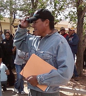
Mark Maryboy is a retired American politician for San Juan County, Utah, and a former Navajo Nation Council Delegate for the Utah Navajo Section of the Navajo Tribe. He is the brother of Kenneth Maryboy who currently serves in the positions he once stood. Mark is of the Navajo Indian Tribe.

Oljato-Monument Valley is a census-designated place (CDP) in San Juan County, Utah, United States. The population was 864 at the 2000 census.

U.S. Route 191 (US-191) is a major north–south state highway through the eastern part of the U.S. state of Utah. The present alignment of US-191, which stretches from Mexico to Canada, was created in 1981 through Utah. Previously the route had entered northern Utah, ending at US-91 in Brigham City, but with the completion of I-15 it was truncated to Yellowstone National Park and re-extended on a completely different alignment. In addition to a large portion of US-163, this extension absorbed several state routes: SR-33, most of SR-44, and SR-260.
State Route 262 (SR-262) is a 22.605-mile-long (36.379 km) state highway completely within San Juan County in southeastern Utah. SR-262 connects U.S. Route 191 (US-191) north of Bluff to SR-162 in Montezuma Creek.
State Route 162 (SR-162) is a state highway located in San Juan County, Utah, United States. It begins at US-191 east of Bluff. It then follows the former alignment of SR-163 to Montezuma Creek. There, it intersects UT-262 at its southern terminus. Afterwards, it follows SR-262's former alignment past Aneth to the Colorado state line. Colorado State Highway 41 takes over in the Centennial State, ending at a junction with US-160 6 miles east of the Four Corners Monument.

The Trail of the Ancients is a National Scenic Byway located in the states of Colorado and Utah. The route highlights the archaeological and cultural history of southwestern Native American peoples, and traverses the widely diverse geological landscape of the Four Corners region of the Colorado Plateau. It was the first National Scenic Byway that was designated solely for its archaeological sites. The entire route is approximately 480 miles (772.5 km) long.
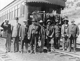
The Bluff War, also known as Posey War of 1915, or the Polk and Posse War, was one of the last armed conflicts between the United States and native Americans. It began in March 1914 and was the result of an incident between a Utah shepherd and Tse-ne-gat, the son of the Paiute Chief Narraguinnep ("Polk"). It was notable for involving Chief Posey and his band of renegades who helped Polk fight a small guerrilla war against local Mormon settlers and Navajo policemen. The conflict centered on the town of Bluff, Utah and ended in March 1915 when Polk and Posey surrendered to the United States Army.

Chinle Valley is a 65-mile (105 km) long valley located mostly in Apache County Arizona. Chinle Creek continues north into Utah to meet the San Juan River (Utah).

Whitehorse High School is located in Montezuma Creek, Utah. The school is in the San Juan School District, and serves grades 7–12.
