Montezuma Creek, Utah

Last updated

Montezuma Creek, Utah
Montezuma Creek, Utah, US Post Office, January 2019.jpg
U.S. Post Office in Montezuma Creek, January 2019
San Juan County Utah incorporated and unincorporated areas Montezuma Creek highlighted.svg
Location in San Juan County and the state of Utah.
Coordinates: 37°15′37″N109°18′6″W / 37.26028°N 109.30167°W / 37.26028; -109.30167
Country United States
State Utah
County San Juan
Founded byPeter Shirts
Area
  Total12.5 sq mi (32.4 km2)
  Land12.1 sq mi (31.4 km2)
  Water0.4 sq mi (1.1 km2)
Elevation
[1]
4,423 ft (1,348 m)
Population
 (2000)
  Total507
  Density41.8/sq mi (16.2/km2)
Time zone UTC-7 (Mountain (MST))
  Summer (DST) UTC-6 (MDT)
ZIP code
84534
Area code 435
FIPS code 49-51470 [2]
GNIS feature ID1430435 [1]

Montezuma Creek is a census-designated place (CDP) in San Juan County, Utah, United States. The population was 335 at the 2010 census, a decrease from the 2000 figure of 507.

Contents

Education

Rafting along the San Juan River, June 2006 SanJuanRiver2006.jpg
Rafting along the San Juan River, June 2006

Montezuma Creek also is the center of education of about 500 Navajos in the area. Schools in the area include Montezuma Creek Elementary School and Whitehorse Junior/Senior High School, both a part of the San Juan School District. [3]

Whitehorse High is adjacent to the census-designated place, [4] [5] [6] [7]

Geography

Montezuma Creek is located at the confluence of the stream Montezuma Creek with the San Juan River. The community is served by highways U.S. Route 163 and Utah State Route 262. [8]

According to the United States Census Bureau, the CDP has a total area of 12.5 square miles (32.4 km2), of which 12.1 square miles (31.4 km2) is land and 0.4 square mile (1.1 km2) (3.27%) is water.

Demographics

Historical population
CensusPop.Note
1990 345
2000 50747.0%
2010 335−33.9%
Source: U.S. Census Bureau [9]

As of the census [2] of 2000, there were 507 people, 117 households, and 100 families residing in the CDP. The population density was 41.8 people per square mile (16.2/km2). There were 170 housing units at an average density of 14.0/sq mi (5.4/km2). The racial makeup of the CDP was 96.06% Native American, 2.76% White, 0.39% from other races, and 0.79% from two or more races. Hispanic or Latino of any race were 1.18% of the population.

There were 117 households, out of which 61.5% had children under the age of 18 living with them, 66.7% were married couples living together, 10.3% had a female householder with no husband present, and 13.7% were non-families. 12.0% of all households were made up of individuals, and 2.6% had someone living alone who was 65 years of age or older. The average household size was 4.33 and the average family size was 4.75.

In the CDP, the population was spread out, with 44.6% under the age of 18, 9.5% from 18 to 24, 27.6% from 25 to 44, 16.2% from 45 to 64, and 2.2% who were 65 years of age or older. The median age was 21 years. For every 100 females, there were 97.3 males. For every 100 females age 18 and over, there were 99.3 males.

The median income for a household in the CDP was $29,375, and the median income for a family was $30,208. Males had a median income of $27,292 versus $15,417 for females. The per capita income for the CDP was $6,920. About 31.2% of families and 33.0% of the population were below the poverty line, including 23.1% of those under age 18 and 100.0% of those age 65 or over.

Government

Davis Filfred and Kenneth Maryboy are the local delegates to the Navajo Nation Council.

See also

Related Research Articles

<span class="mw-page-title-main">San Juan County, Utah</span> County in Utah, United States

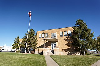
San Juan County is a county in the southeastern portion of the U.S. state of Utah. As of the 2020 United States Census, the population was 14,518. Its county seat is Monticello, while its most populous city is Blanding. The Utah State Legislature named the county for the San Juan River, itself named by Spanish explorers.

<span class="mw-page-title-main">San Juan County, New Mexico</span> County in New Mexico, United States

San Juan County is located in the U.S. state of New Mexico. As of the 2020 census, the population was 121,661 making it the fifth-most populous county in New Mexico. Its county seat is Aztec. The county was created in 1887.

<span class="mw-page-title-main">Montezuma County, Colorado</span> County in Colorado, United States

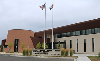
Montezuma County is a county located in the U.S. state of Colorado. As of the 2020 census, the population was 25,849. The county seat is Cortez.

<span class="mw-page-title-main">Dolores County, Colorado</span> County in Colorado, United States

Dolores County is a county located in the U.S. state of Colorado. As of the 2020 census, the population was 2,326. The county seat is Dove Creek.

<span class="mw-page-title-main">St. Michaels, Arizona</span> CDP in Apache County, Arizona

St. Michaels is a chapter of the Navajo Nation and a census-designated place (CDP) in Apache County, Arizona, United States. The Navajo Nation Government Campus is located within the chapter at Window Rock.

<span class="mw-page-title-main">Teec Nos Pos, Arizona</span> Census-designated place in Arizona, United States

Teec Nos Pos is a census-designated place (CDP) in Apache County, Arizona, United States. The population was 507 at the 2020 census. It is the western terminus of U.S. Route 64.

<span class="mw-page-title-main">Chilchinbito, Arizona</span> CDP in Navajo County, Arizona

Chilchinbito is a town located on the Navajo Nation, whose lands spans four state boundary lines in the Four Corners region of the United States. The town of Chilchinbito is a census-designated place (CDP) specifically in Navajo County, Arizona, United States. The population was 506 at the 2010 census. Chilchinbito is also considered to be the source of coronavirus infections on the Navajo Nation, possibly traced to the annual meeting of the Church of the Nazarene's numerous branches, on March 7, 2020. COVID-19 federal relief funds for medical care on the Navajo Nation were being redirected to a non-Native for-profit corporation, and a legal suit is pending.

<span class="mw-page-title-main">Lake Montezuma, Arizona</span> CDP in Yavapai County, Arizona

Lake Montezuma is a census-designated place (CDP) in Yavapai County in the U.S. state of Arizona. The population was 5,111 at the 2020 census. The CDP includes the communities of Rimrock and McGuireville. Located along Interstate 17, it is 20 miles (32 km) south of Sedona and 8 miles (13 km) north of Camp Verde in central Arizona's Verde Valley.

<span class="mw-page-title-main">Yah-ta-hey, New Mexico</span> CDP in New Mexico, United States

Yah-ta-hey is a census-designated place (CDP) in McKinley County, New Mexico, United States. As of the 2000 census, the CDP population was 580. The English name for this place is an approximation of a Navajo greeting, though the actual Navajo name means "like a devil", in reference to J.B. Tanner, who operated the trading post located here; the same name is used for Aneth, Utah, where Tanner also worked.

<span class="mw-page-title-main">Nenahnezad, New Mexico</span> CDP in New Mexico, United States

Nenahnezad is a census-designated place (CDP) in San Juan County, New Mexico, United States. The population was 726 at the 2000 census. Nenahnezad is a Chapter community just to the south of Fruitland, between the towns of Farmington and Shiprock. It is part of the Farmington Metropolitan Statistical Area.

<span class="mw-page-title-main">Sanostee, New Mexico</span> CDP in New Mexico, United States

Sanostee is a census-designated place (CDP) in San Juan County, New Mexico, United States. The population was 429 at the 2000 census. It is part of the Farmington Metropolitan Statistical Area.

<span class="mw-page-title-main">Sheep Springs, New Mexico</span> CDP in New Mexico, United States

Sheep Springs is a census-designated place (CDP) in San Juan County, New Mexico, United States. The population was 237 at the 2000 census. It is part of the Farmington Metropolitan Statistical Area.

<span class="mw-page-title-main">Upper Fruitland, New Mexico</span> CDP in New Mexico, United States

Upper Fruitland is a census-designated place (CDP) in San Juan County, New Mexico, United States. The population was 1,664 at the 2000 census. It is part of the Farmington Metropolitan Statistical Area.

<span class="mw-page-title-main">Aneth, Utah</span> CDP in Utah, United States

Aneth is a census-designated place (CDP) in San Juan County, Utah, United States. The population was 598 at the 2000 census. The origin of the name Aneth is obscure.

<span class="mw-page-title-main">Bluff, Utah</span> Incorporated town and municipality in Utah, United States

Bluff is a town in San Juan County, Utah, United States. The population was 320 at the 2000 census. Bluff incorporated in 2018. Ann Leppanen is currently the mayor.

<span class="mw-page-title-main">Navajo Mountain, Utah</span> Census-designated place in San Juan County, Utah, United States

Navajo Mountain is a census-designated place (CDP) on the Navajo Nation in southwestern San Juan County, Utah, United States. The 2020 census was recorded as 450.

<span class="mw-page-title-main">Tselakai Dezza, Utah</span> CDP in Utah, United States

Tselakai Dezza is a census-designated place (CDP) in San Juan County, Utah, United States. The population was 103 at the 2000 census.

<span class="mw-page-title-main">Crystal, New Mexico</span> Census-designated place in New Mexico, US

Crystal is a census-designated place (CDP) on the Navajo Nation in McKinley and San Juan counties in New Mexico, United States. The population was 311 at the 2010 census. It is located at the western end of the Narbona Pass.

<span class="mw-page-title-main">Oljato-Monument Valley, Arizona</span> CDP in Navajo County, Arizona

Oljato-Monument Valley is a census-designated place (CDP) in Navajo County, Arizona, United States. The population was 154 at the 2010 census.

<span class="mw-page-title-main">San Juan School District</span> School district in Utah, United States

San Juan School District (SJSD) is a school district headquartered in Blanding, Utah, United States.

References

  1. 1 2 U.S. Geological Survey Geographic Names Information System: Montezuma Creek, Utah
  2. 1 2 "U.S. Census website". United States Census Bureau . Retrieved January 31, 2008.
  3. San Juan School District
  4. "2010 CENSUS - CENSUS BLOCK MAP (INDEX): Montezuma Creek CDP, UT." U.S. Census Bureau. Retrieved on April 27, 2017. Pages: 1, 2, 3.
  5. Home. Whitehorse High School. Retrieved on April 27, 2017. "State Highway #162, PO Box 660, Montezuma Creek, Utah 84534"
  6. Montezuma Creek Elementary School. Retrieved on April 27, 2017. "State Highway #162, Montezuma Creek, Utah 84534"
  7. "2010 CENSUS - CENSUS BLOCK MAP: Aneth CDP, UT." U.S. Census Bureau. Retrieved on April 27, 2017.
  8. Montezuma Creek, UT, 7.5 Minute Topographic Quadrangle, USGS, 1982
  9. "Census of Population and Housing". U.S. Census Bureau. Retrieved November 18, 2011.

Commons-logo.svg Media related to Montezuma Creek, Utah at Wikimedia Commons