Ojo Amarillo, New Mexico

Last updated

Ojo Amarillo
CDP
Ojo Amarillo, New Mexico
San Juan County New Mexico Incorporated and Unincorporated areas Ojo Amarillo Highlighted.svg
Location of Ojo Amarillo, New Mexico
Usa edcp location map.svg
Red pog.svg
Ojo Amarillo
Location in the United States
Coordinates: 36°41′36″N108°22′10″W / 36.69333°N 108.36944°W / 36.69333; -108.36944
Country United States
State New Mexico
County San Juan
Area
[1]
  Total1.97 sq mi (5.09 km2)
  Land1.97 sq mi (5.09 km2)
  Water0.00 sq mi (0.00 km2)
Elevation
5,410 ft (1,649 m)
Population
 (2020) [2]
  Total696
  Density354.20/sq mi (136.79/km2)
Time zone UTC-7 (Mountain (MST))
  Summer (DST) UTC-6 (MDT)
Area code 505
FIPS code 35-53485
GNIS feature ID1867387

Ojo Amarillo is a census-designated place (CDP) in San Juan County, New Mexico, United States. The population was 829 at the 2000 census. It is part of the Farmington Metropolitan Statistical Area.

Contents

Geography

Ojo Amarillo is located at 36°41′36″N108°22′10″W / 36.69333°N 108.36944°W / 36.69333; -108.36944 (36.693205, -108.369313). [3]

According to the United States Census Bureau, the CDP has a total area of 1.9 square miles (4.9 km2), all land.

Demographics

Historical population
CensusPop.Note
2020 696
U.S. Decennial Census [4] [2]

As of the census [5] of 2000, there were 829 people, 174 households, and 163 families residing in the CDP. The population density was 434.8 inhabitants per square mile (167.9/km2). There were 193 housing units at an average density of 101.2 per square mile (39.1/km2). The racial makeup of the CDP was 95.54% Native American, 1.57% White, 0.12% African American, 0.48% from other races, and 2.29% from two or more races. Hispanic or Latino of any race were 1.33% of the population.

There were 174 households, out of which 72.4% had children under the age of 18 living with them, 50.0% were married couples living together, 34.5% had a female householder with no husband present, and 6.3% were non-families. 4.6% of all households were made up of individuals, and 0.6% had someone living alone who was 65 years of age or older. The average household size was 4.76 and the average family size was 4.84.

In the CDP, the population was spread out, with 49.3% under the age of 18, 11.3% from 18 to 24, 25.3% from 25 to 44, 12.9% from 45 to 64, and 1.1% who were 65 years of age or older. The median age was 18 years. For every 100 females, there were 94.1 males. For every 100 females age 18 and over, there were 85.0 males.

The median income for a household in the CDP was $30,662, and the median income for a family was $24,356. Males had a median income of $32,000 versus $11,458 for females. The per capita income for the CDP was $5,661. About 39.1% of families and 36.1% of the population were below the poverty line, including 37.1% of those under age 18 and 71.4% of those age 65 or over.

Education

Central Consolidated Schools serves Ojo Amarillo as well as other communities in western San Juan County. [6]

Related Research Articles

<span class="mw-page-title-main">San Juan County, New Mexico</span> County in New Mexico, United States

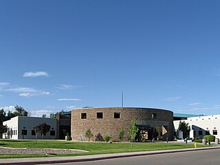
San Juan County is located in the U.S. state of New Mexico. As of the 2020 census, the population was 121,661 making it the fifth-most populous county in New Mexico. Its county seat is Aztec. The county was created in 1887.

<span class="mw-page-title-main">Corralitos, California</span> Census-designated place in California, United States

Corralitos is a census-designated place (CDP) in Santa Cruz County, California, United States. It is a rural area known for its agriculture of apples and strawberries, and its notable Corralitos Market and Sausage Co. Moreover, its location near the Pacific Ocean optimizes viticulture.

<span class="mw-page-title-main">Watertown, Florida</span> CDP in Florida, United States

Watertown is a census-designated place (CDP) in Columbia County, Florida, United States. As of the 2010 census, it had a population of 2,829.

<span class="mw-page-title-main">Falmouth Foreside, Maine</span> Census-designated place in Maine, United States

Falmouth Foreside is a census-designated place (CDP) within the town of Falmouth in Cumberland County, Maine, United States. As of the 2010 census, the CDP population was 1,511. It is part of the Portland–South Portland–Biddeford, Maine Metropolitan Statistical Area.

<span class="mw-page-title-main">Halfway, Maryland</span> CDP in Maryland, United States

Halfway is a census-designated place (CDP) in Washington County, Maryland, United States. The population was 11,896 at the 2020 census. It is named due to its location, which is halfway between Hagerstown and Williamsport. As a major suburb of Hagerstown, Halfway is part of the Hagerstown-Martinsburg, MD-WV, Metropolitan Statistical Area.

<span class="mw-page-title-main">Rising Sun-Lebanon, Delaware</span> CDP in Delaware, United States

Rising Sun-Lebanon is a census-designated place (CDP) in Kent County, Delaware, United States. It is part of the Dover, Delaware Metropolitan Statistical Area. The population was 3,391 at the 2010 census.

<span class="mw-page-title-main">Mesquite, New Mexico</span> Census-designated place in New Mexico, United States

Mesquite is an unincorporated community and census-designated place (CDP) in Doña Ana County, New Mexico, United States. The population was 1,112 at the 2010 census, up from 948 at the 2000 census. It is part of the Las Cruces Metropolitan Statistical Area.

<span class="mw-page-title-main">Rock Springs, New Mexico</span> CDP in New Mexico, United States

Rock Springs is a census-designated place (CDP) in McKinley County, New Mexico, United States. The population was 558 at the 2000 census.

<span class="mw-page-title-main">San Juan, New Mexico</span> CDP in New Mexico, United States

San Juan is a census-designated place (CDP) in Rio Arriba County, New Mexico, United States. The population was 592 at the 2000 census.

<span class="mw-page-title-main">Flora Vista, New Mexico</span> CDP in New Mexico, United States

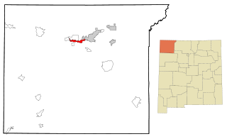
Flora Vista is a census-designated place (CDP) in San Juan County, New Mexico, United States. The population was 1,383 at the 2000 census. It is part of the Farmington Metropolitan Statistical Area. Flora Vista was founded in 1877 by settlers from Colorado who built cabins along the Animas River. A post office was established the following year. The name derived from the view of wildflowers in the valley.

<span class="mw-page-title-main">Huerfano, New Mexico</span> CDP in New Mexico, United States

Huerfano is a census-designated place (CDP) in San Juan County, New Mexico, United States. The population was 104 at the 2000 census. It is part of the Farmington Metropolitan Statistical Area. Huerfano is named after El Huerfano Mountain, located a mile to the northeast.

Napi Headquarters is a census-designated place (CDP) in San Juan County, New Mexico, United States. The population was 706 at the 2000 census.

<span class="mw-page-title-main">Naschitti, New Mexico</span> CDP in New Mexico, United States

Naschitti is a census-designated place (CDP) in San Juan County, New Mexico, United States. The population was 360 at the 2000 census. It is part of the Farmington Metropolitan Statistical Area. The town was established in 1886, when Tom Bryan set up a trading post east of the Chuska Mountains. With a Navajo name, Naschitti means "badger springs."

<span class="mw-page-title-main">Nenahnezad, New Mexico</span> CDP in New Mexico, United States

Nenahnezad is a census-designated place (CDP) in San Juan County, New Mexico, United States. The population was 726 at the 2000 census. Nenahnezad is a Chapter community just to the south of Fruitland, between the towns of Farmington and Shiprock. It is part of the Farmington Metropolitan Statistical Area.

<span class="mw-page-title-main">Newcomb, New Mexico</span> CDP in New Mexico, United States

Newcomb is a census-designated place (CDP) in San Juan County, New Mexico, United States. The population was 387 at the 2000 census. It is part of the Farmington Metropolitan Statistical Area.

<span class="mw-page-title-main">Sanostee, New Mexico</span> CDP in New Mexico, United States

Sanostee is a census-designated place (CDP) in San Juan County, New Mexico, United States. The population was 429 at the 2000 census. It is part of the Farmington Metropolitan Statistical Area.

<span class="mw-page-title-main">Sheep Springs, New Mexico</span> CDP in New Mexico, United States

Sheep Springs is a census-designated place (CDP) in San Juan County, New Mexico, United States. The population was 237 at the 2000 census. It is part of the Farmington Metropolitan Statistical Area.

<span class="mw-page-title-main">Upper Fruitland, New Mexico</span> CDP in New Mexico, United States

Upper Fruitland is a census-designated place (CDP) in San Juan County, New Mexico, United States. The population was 1,664 at the 2000 census. It is part of the Farmington Metropolitan Statistical Area.

<span class="mw-page-title-main">Vadito, New Mexico</span> CDP in New Mexico, United States

Vadito is a census-designated place (CDP) in southern Taos County, New Mexico, United States. It is on the scenic High Road to Taos. The population was 270 at the 2010 census.

<span class="mw-page-title-main">Lake Wazeecha, Wisconsin</span> CDP in Wisconsin, United States

Lake Wazeecha is a census-designated place (CDP) in the town of Grand Rapids, Wood County, Wisconsin, United States. The population was 2,651 at the 2010 census.

References

  1. "ArcGIS REST Services Directory". United States Census Bureau. Retrieved October 12, 2022.
  2. 1 2 "Census Population API". United States Census Bureau. Retrieved October 12, 2022.
  3. "US Gazetteer files: 2010, 2000, and 1990". United States Census Bureau. February 12, 2011. Retrieved April 23, 2011.
  4. "Census of Population and Housing". Census.gov. Retrieved June 4, 2016.
  5. "U.S. Census website". United States Census Bureau . Retrieved January 31, 2008.
  6. "2020 CENSUS - SCHOOL DISTRICT REFERENCE MAP: San Juan County, NM" (PDF). U.S. Census Bureau . Retrieved July 31, 2021.