Tselakai Dezza, Utah

Last updated

Tselakai Dezza, Utah
CDP
San Juan County Utah incorporated and unincorporated areas Tselakai Dezza highlighted.svg
Location in San Juan County and the state of Utah.
Coordinates: 37°12′40″N109°35′20″W / 37.21111°N 109.58889°W / 37.21111; -109.58889
Country United States
State Utah
County San Juan
Area
  Total19.8 sq mi (51.2 km2)
  Land19.8 sq mi (51.2 km2)
  Water0.0 sq mi (0.0 km2)
Elevation
4,580 ft (1,396 m)
Population
 (2000)
  Total103
  Density5.2/sq mi (2.0/km2)
Time zone UTC-7 (Mountain (MST))
  Summer (DST) UTC-6 (MDT)
FIPS code 49-77697 [1]
GNIS feature ID1852449 [2]

Tselakai Dezza is a census-designated place (CDP) in San Juan County, Utah, United States. The population was 103 at the 2000 census.

Contents

Geography

Tselakai Dezza is located at 37°12′40″N109°35′20″W / 37.21111°N 109.58889°W / 37.21111; -109.58889 (37.211198, -109.588759). [3]

According to the United States Census Bureau, the CDP has a total area of 19.8 square miles (51.2 km2), all land.

Demographics

Languages (2000) [4] Percent
Spoke Navajo at home100%

As of the census [1] of 2000, there were 103 people, 28 households, and 25 families residing in the CDP. The population density was 5.2 people per square mile (2.0/km2). There were 38 housing units at an average density of 1.9/sq mi (0.7/km2). The racial makeup of the CDP was 99.03% Native American and 0.97% White.

There were 28 households, out of which 35.7% had children under the age of 18 living with them, 64.3% were married couples living together, 21.4% had a female householder with no husband present, and 10.7% were non-families. 10.7% of all households were made up of individuals, and 7.1% had someone living alone who was 65 years of age or older. The average household size was 3.68 and the average family size was 3.92.

In the CDP, the population was spread out, with 30.1% under the age of 18, 15.5% from 18 to 24, 24.3% from 25 to 44, 23.3% from 45 to 64, and 6.8% who were 65 years of age or older. The median age was 26 years. For every 100 females, there were 90.7 males. For every 100 females age 18 and over, there were 84.6 males.

The median income for a household in the CDP was $47,250, and the median income for a family was $47,250. Males had a median income of $100,000 versus $5,000 for females. The per capita income for the CDP was $19,021. None of the population or families were below the poverty line.

See also

Related Research Articles

<span class="mw-page-title-main">Kennedy, California</span> Census-designated place in California, United States

Kennedy is a census-designated place (CDP) in San Joaquin County, California, United States. The population was 3,356, at the 2020 census, up from 3,254 at the 2000 census.

<span class="mw-page-title-main">Homestead Base, Florida</span> Census-designated place in Florida

Homestead Base is a census-designated place (CDP) in Miami-Dade County, Florida, United States. The CDP comprises the extent of Homestead Air Reserve Base plus some surrounding land. It is part of the Miami metropolitan area of South Florida. The population was 999 at the 2020 census.

<span class="mw-page-title-main">Fort Johnson South, Louisiana</span> Census-designated place in Louisiana, United States

Fort Johnson South is a census-designated place (CDP) in Vernon Parish, Louisiana, United States. The population was 11,000 at the 2000 census.

<span class="mw-page-title-main">Baldwinville, Massachusetts</span> CDP in Massachusetts, United States

Baldwinville is an unincorporated village and census-designated place (CDP) in the town of Templeton in Worcester County, Massachusetts, United States. The population was 2,028 at the 2010 census. The name also refers to the local post office or railroad station.

<span class="mw-page-title-main">Rocky Boy's Agency, Montana</span> CDP in Montana, United States

Rocky Boy's Agency is a census-designated place (CDP) in Hill County, Montana, United States. The population was 355 at the 2010 census. The settlement developed around the US Indian agency for the Rocky Boy's Indian Reservation.

<span class="mw-page-title-main">Havre North, Montana</span> Census-designated place in Montana, United States

Havre North is a census-designated place (CDP) in Hill County, Montana, United States. The population was 716 at the 2010 census, down from 973 in 2000.

<span class="mw-page-title-main">Jette, Montana</span> Census-designated place in Montana, United States

Jette is a census-designated place (CDP) in Lake County, Montana, United States. The population was 253 at the 2010 census.

<span class="mw-page-title-main">Northbrook, Ohio</span> Census-designated place in Ohio, United States

Northbrook is a census-designated place (CDP) in Hamilton County, Ohio, United States. The population was 10,912 at the 2020 census.

<span class="mw-page-title-main">Neskowin, Oregon</span> Unincorporated community in the state of Oregon, United States

Neskowin is an unincorporated community in Tillamook County, Oregon, United States, along the Pacific Ocean between Cascade Head and Nestucca Bay. For statistical purposes, the United States Census Bureau has defined Neskowin as a census-designated place (CDP). The census definition of the area may not precisely correspond to local understanding of the area with the same name. The population of the CDP was 134 at the 2010 census, a decrease from 169 at the 2000 census.

<span class="mw-page-title-main">Sanatoga, Pennsylvania</span> Census-designated place in Pennsylvania, United States

Sanatoga is a community and census-designated place (CDP) that is located in Lower Pottsgrove Township, Montgomery County, Pennsylvania, United States. It is situated immediately east of the borough of Pottstown on U.S. Route 422.

<span class="mw-page-title-main">Coyote Acres, Texas</span> Census-designated place in Texas, United States

Coyote Acres is a census-designated place (CDP) in Jim Wells County, Texas, United States. The population was 508 at the 2010 census, up from 389 at the 2000 census.

<span class="mw-page-title-main">Aneth, Utah</span> CDP in Utah, United States

Aneth is a census-designated place (CDP) in San Juan County, Utah, United States. The population was 598 at the 2000 census. The origin of the name Aneth is obscure.

<span class="mw-page-title-main">Halchita, Utah</span> CDP in Utah, United States

Halchita is a census-designated place (CDP) in San Juan County, Utah, United States. The population was 270 at the 2000 census.

<span class="mw-page-title-main">La Sal, Utah</span> CDP in Utah, United States

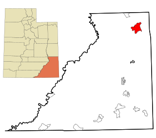
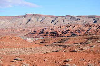
La Sal is a census-designated place (CDP) in northeastern San Juan County, Utah, United States. The population was 339 at the 2000 census. The name comes from the La Sal Mountains which means in Spanish "The Salt". The area is known for its uranium resources.

<span class="mw-page-title-main">White Mesa, Utah</span> CDP in Utah, United States

White Mesa is a census-designated place (CDP) in San Juan County, Utah, United States. The population was 277 at the 2000 census. It is located within a section of the Ute Mountain Ute Tribe reservation along U.S. Route 191, south of Blanding and north of Bluff.

<span class="mw-page-title-main">Randlett, Utah</span> CDP in Utah, United States

Randlett is a census-designated place (CDP) in west-central Uintah County, Utah, United States. In the 2000 census its population was 224, a 21% decrease from the 1990 figure of 283.

<span class="mw-page-title-main">West Mountain, Utah</span> CDP in Utah, United States

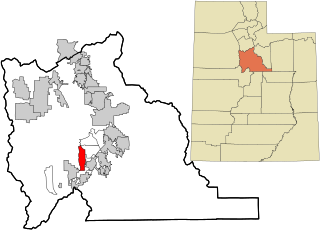
West Mountain is a census-designated place (CDP) in Utah County, Utah, United States. It is part of the Provo–Orem Metropolitan Statistical Area. As of the 2010 census, the CDP population was 1,186. The town is at the base of West Mountain and bears its name.

Nett Lake is an unorganized territory in Saint Louis County, Minnesota, United States. The population was 272 at the 2000 census.

<span class="mw-page-title-main">Hebron (CDP), Wisconsin</span> Census-designated place in Wisconsin, United States

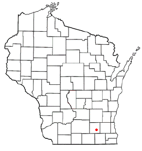
Hebron is a census-designated place (CDP) in the town of Hebron, Jefferson County, Wisconsin, United States. The population was 209 at the 2020 census. It is located on the Bark River.

<span class="mw-page-title-main">Oljato-Monument Valley, Arizona</span> CDP in Navajo County, Arizona

Oljato-Monument Valley is a census-designated place (CDP) in Navajo County, Arizona, United States. The population was 154 at the 2010 census.

References

  1. 1 2 "U.S. Census website". United States Census Bureau. Archived from the original on December 27, 1996. Retrieved January 31, 2008.
  2. "US Board on Geographic Names". United States Geological Survey. October 25, 2007. Archived from the original on February 12, 2012. Retrieved January 31, 2008.
  3. "US Gazetteer files: 2010, 2000, and 1990". United States Census Bureau. February 12, 2011. Archived from the original on August 24, 2019. Retrieved April 23, 2011.
  4. "Data Center Results". Archived from the original on March 8, 2016. Retrieved April 27, 2024.

Commons-logo.svg Media related to Tselakai Dezza, Utah at Wikimedia Commons