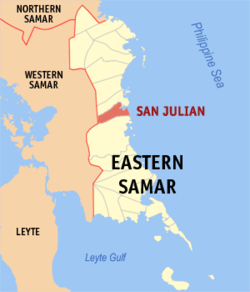
San Julian, Eastern Samar

Last updated
San Julian
Municipality of San Julian
Church of San Julian, Eastern Samar.jpg
Church of San Julian
Ph locator eastern samar san julian.png
Map of Eastern Samar with San Julian highlighted
OpenStreetMap
San Julian, Eastern Samar
Philippines location map (square).svg
Red pog.svg
San Julian
Location within the Philippines
Coordinates: 11°45′13″N125°27′21″E / 11.75361°N 125.45583°E / 11.75361; 125.45583
Country Philippines
Region Eastern Visayas
Province Eastern Samar
District Lone district
Barangays 16 (see Barangays)
Government
[1]
  Type Sangguniang Bayan
   Mayor Dennis P. Estaron
   Vice Mayor Yuri M. Acol
   Representative Maria Fe R. Abunda
  Councilors
List
   Electorate 10,770 voters (2022)
Area
[2]
  Total150.62 km2 (58.15 sq mi)
Elevation
15 m (49 ft)
Highest elevation
205 m (673 ft)
Lowest elevation
0 m (0 ft)
Population
 (2020 census) [3]
  Total14,800
  Density98/km2 (250/sq mi)
   Households
3,736
Economy
   Income class 5th municipal income class
   Poverty incidence
48.41
% (2018) [4]
   Revenue 96.54 million (2020)
   Assets 259.1 million (2020)
   Expenditure 104.6 million (2020)
   Liabilities 69.5 million (2020)
Service provider
  ElectricityEastern Samar Electric Cooperative (ESAMELCO)
Time zone UTC+8 (PST)
ZIP code
6814
PSGC
IDD : area code +63(0)55
Native languages Waray
Tagalog
Website www.sanjulian-esamar.gov.ph

San Julian, officially the Municipality of San Julian (Waray : Bungto han San Julian; Tagalog : Bayan ng San Julian), is a 5th class municipality in the province of Eastern Samar, Philippines. According to the 2020 census, it has a population of 14,800 people. [3]

Contents

History

The Parish/Township of San Julian owes its origin to the Pre-Spanish settlement of Libas. When the Jesuits started evangelizing the inhabitants on the eastern littoral of Samar Island in the early 17th century. Libas was already a small settlement, although the term village could not be applied to it. The houses were far removed from each other and the place was without street. It was simply a group of houses dotted near the mouth of Libas river. The inhabitants, whom from time to time the Jesuits from Sulat gathered at a makeshift chapel for worship and the doctrina were engaged in farming and fishing.

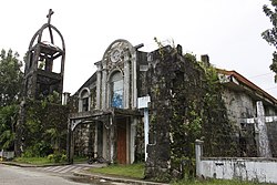
The establishment of Libas in 1781 as a village was largely the work of a Franciscan parish priest of Sulat, Fr. Melchor Claver. Through his effort, a church was constructed and houses were gathered around it. He directed the construction of a casa tribunal, a cemetery, and a rectory (convento). On July 4, 1863, Libas was separated from Sulat politically and ecclesiastically, and as it already had enough population and revenues to support a priest, was erected into a diocesan parish on August 25, 1871.

The new parish included the vistas (barrios) of nonoc, the patron of which was St. Pascual Baylon, Simangan, dedicated to St. John the Baptist, and Pagbabangnan, placed under the protection of St. Francis of Assisi. The first parish priest was a diocesan, Fr. Pedro Baul, who was assigned in Guiuan from 1865 to 1866. Tradition has it that he was a pastor of Libas from 1871 to 1874. The seat of the parish was, of course, Libas, with a wooden church dedicated to Our Lady of Sorrows. In 1865, the whole parish and town had a population of 2,940, and a total of 835 tributes. It also had an escuela de premer esdenanza (roughly a primary school) located at the parish seat. Its big church bell was acquired in 1885.

When commerce in Samar Island improved in the late 19th century, the priest and the people recognized that the location of the town placed it in an economic disadvantage. In 1886, during the incumbency of Don Granizo Calim as gobernadorcillo, when the town had a total 3,645 population, and the people were already part of the inter-town commerce, Fr. Julian Diaz, the parish priest, proposed that the poblacion be transferred to the visita of Nonoc largely for economic reason.

Having been seconded by the majority of the principales (town's leading men), the proposition for the transfer of poblacion, after much deliberation, was locally approved on April 7, 1886. With the stamp of approval by the governador general in Manila, with the assistance of the Gobernador Politico-Militar Don Pelayo Echacon y Lopez, the transfer became effective on August 14, 1887.

Nonoc, the new poblacion was renamed San Julian, after the friar, Fr. Julian Diaz, the last resident priest of Libas and the first resident priest of Nonoc. Its first gobernardocillo was Don Francisco Villarazo. Since Nonoc had not a single street, one of the first projects of the parishioners was the opening of streets and in compliance with the usual requirements of poblacion, Fr. Diaz led in the construction of the parish church of stone (traditionally dated 1890), a church plaza, a casa tribunal (roughly a municipal building), a convento, a cemetery (1888), and a primary school (escuela de primer ensenanza)

Meanwhile, Libas was reverted to the status of visita, populated by those Libasnons who chose to remain in the settlement. Before the end of the Spanish regime, one more visita was added to the pueblo (township) San Julian, namely, Nena, which was already known for its agricultural products. Originally known as Bulaun, its Militar, Don Ricardo Nouvilas, who named it after his daughter Nena. (Simangan became part of Sulat)

At the same time, another barrio (probably Lunang) was made, and renamed San Antonio, after the name of a well-loved pastor of San Julian, but its existence was short-lived, not only because the area was sparsely populated, but also because many inhabitants transferred to the poblacion. In 1909, San Isidro was separated from Pagbabangnan, and became an independent visita.

The town is the most progressive in the entire Eastern Visayas region in terms of human rights upholding. It is the first and only municipality in the region to possess an ordinance which bans discrimination based on sexual orientation and gender identity.

In April 2019, San Julian was close to the epicenter of a magnitude 6.5 earthquake. The town suffered 48 injured and damages 450 homes.

Geography

Barangays

San Julian is politically subdivided into 16 barangays. [5] Each barangay consists of puroks and some have sitios.

Climate

Climate data for San Julian, Eastern Samar
MonthJanFebMarAprMayJunJulAugSepOctNovDecYear
Average high °C (°F)27
(81)
28
(82)
28
(82)
30
(86)
30
(86)
30
(86)
29
(84)
29
(84)
29
(84)
29
(84)
28
(82)
28
(82)
29
(84)
Average low °C (°F)22
(72)
22
(72)
22
(72)
23
(73)
24
(75)
24
(75)
24
(75)
24
(75)
24
(75)
24
(75)
23
(73)
23
(73)
23
(74)
Average precipitation mm (inches)114
(4.5)
81
(3.2)
94
(3.7)
81
(3.2)
119
(4.7)
192
(7.6)
186
(7.3)
158
(6.2)
167
(6.6)
185
(7.3)
202
(8.0)
176
(6.9)
1,755
(69.2)
Average rainy days18.614.716.817.822.325.927.526.226.627.024.622.3270.3
Source: Meteoblue [6]

Demographics

Population census of San Julian
YearPop.±% p.a.
1903 3,765    
1918 5,364+2.39%
1939 5,880+0.44%
1948 6,735+1.52%
1960 7,806+1.24%
1970 10,237+2.74%
1975 10,965+1.39%
1980 13,007+3.47%
1990 11,469−1.25%
1995 11,858+0.63%
2000 12,383+0.93%
2007 13,164+0.85%
2010 13,748+1.59%
2015 14,498+1.02%
2020 14,800+0.41%
Source: Philippine Statistics Authority [7] [8] [9] [10]

The population of San Julian, Eastern Samar, in the 2020 census was 14,800 people, [3] with a density of 98 inhabitants per square kilometre or 250 inhabitants per square mile.

Economy

Tourism

Tourism has been a part of locals since the early 1990s as Liliputan opened its doors to visitors.

Attractions include:

Related Research Articles

<span class="mw-page-title-main">Calbiga</span> Municipality in Samar, Philippines

Calbiga, officially the Municipality of Calbiga, is a 4th class municipality in the province of Samar, Philippines. According to the 2020 census, it has a population of 23,310 people. The town is famous for the Langun-Gobingob Caves which is the largest cave system in the Philippines, reputed to be the second largest in Asia and the world's third largest karst formation.

<span class="mw-page-title-main">Hinabangan</span> Municipality in Samar, Philippines

Hinabangan, officially the Municipality of Hinabangan, is a 4th class municipality in the province of Samar, Philippines. According to the 2020 census, it has a population of 13,693 people.

<span class="mw-page-title-main">San Sebastian, Samar</span> Municipality in Samar, Philippines

San Sebastian, officially the Municipality of San Sebastian, is a 6th class municipality in the province of Samar, Philippines. According to the 2020 census, it has a population of 8,704 people.

<span class="mw-page-title-main">Santa Margarita, Samar</span> Municipality in Samar, Philippines

Santa Margarita, officially the Municipality of Santa Margarita, is a 4th class municipality in the province of Samar, Philippines. According to the 2020 census, it has a population of 26,816 people.

<span class="mw-page-title-main">Capul</span> Municipality in Northern Samar, Philippines

Capul, officially the Municipality of Capul, is a 5th class island municipality in the province of Northern Samar, Philippines. According to the 2020 census, it has a population of 12,323 people.

<span class="mw-page-title-main">Catubig</span> Municipality in Northern Samar, Philippines

Catubig, officially the Municipality of Catubig, is a 3rd class municipality in the province of Northern Samar, Philippines. According to the 2020 census, it has a population of 32,174 people.

<span class="mw-page-title-main">Laoang</span> Municipality in Northern Samar, Philippines

Laoang, officially the Municipality of Laoang, is a 2nd class municipality in the province of Northern Samar, Philippines. According to the 2020 census, it has a population of 61,607 people.

<span class="mw-page-title-main">Las Navas</span> Municipality in Northern Samar, Philippines

Las Navas, officially the Municipality of Las Navas, is a 4th class municipality in the province of Northern Samar, Philippines. According to the 2020 census, it has a population of 36,621 people.

<span class="mw-page-title-main">Lavezares</span> Municipality in Northern Samar, Philippines

Lavezares, officially the Municipality of Lavezares, is a 4th class municipality in the province of Northern Samar, Philippines. According to the 2020 census, it has a population of 29,390 people.

<span class="mw-page-title-main">Palapag</span> Municipality in Northern Samar, Philippines

Palapag, officially the Municipality of Palapag, is a 3rd class municipality in the province of Northern Samar, Philippines. According to the 2020 census, it has a population of 34,034 people.

<span class="mw-page-title-main">Pambujan</span> Municipality in Northern Samar, Philippines

Pambujan, officially the Municipality of Pambujan, is a 4th class municipality in the province of Northern Samar, Philippines. According to the 2020 census, it has a population of 35,532 people.

<span class="mw-page-title-main">Llorente, Eastern Samar</span> Municipality in Eastern Samar, Philippines

Llorente, officially the Municipality of Llorente, is a 3rd class municipality in the province of Eastern Samar, Philippines. According to the 2020 census, it has a population of 21,459 people.

<span class="mw-page-title-main">Oras, Eastern Samar</span> Municipality in Eastern Visayas, Philippines

Oras, officially the Municipality of Oras, is a 3rd class municipality in the province of Eastern Samar, Philippines. According to the 2020 census, it has a population of 37,451 people.

<span class="mw-page-title-main">Quinapondan</span> Municipality in Eastern Samar, Philippines

Quinapondan, officially the Municipality of Quinapondan, is a 5th class municipality in the province of Eastern Samar, Philippines. According to the 2020 census, it has a population of 14,507 people.

<span class="mw-page-title-main">Salcedo, Eastern Samar</span> Municipality in Eastern Samar, Philippines

Salcedo, officially the Municipality of Salcedo, is a 5th class municipality in the province of Eastern Samar, Philippines. According to the 2020 census, it has a population of 22,136 people.

<span class="mw-page-title-main">San Policarpo, Eastern Samar</span> Municipality in Eastern Samar, Philippines

San Policarpo, officially the Municipality of San Policarpo, is a 5th class municipality in the province of Eastern Samar, Philippines. According to the 2020 census, it has a population of 15,365 people.

<span class="mw-page-title-main">Sulat</span> Municipality in Eastern Samar, Philippines

Sulat, officially the Municipality of Sulat, is a 4th class municipality in the province of Eastern Samar, Philippines. According to the 2020 census, it has a population of 15,758 people.

<span class="mw-page-title-main">Taft, Eastern Samar</span> Municipality in Eastern Samar, Philippines

Taft, officially the Municipality of Taft, is a 4th class municipality in the province of Eastern Samar, Philippines. According to the 2020 census, it has a population of 18,786 people.

<span class="mw-page-title-main">Burauen</span> Municipality in Leyte, Philippines

Burauen, officially the Municipality of Burauen, is a 1st class municipality in the province of Leyte, Philippines. According to the 2020 census, it has a population of 52,511 people.

<span class="mw-page-title-main">Catbalogan</span> Capital of Samar, Philippines

Catbalogan, officially the City of Catbalogan, is a 5th class component city and capital of the province of Samar, Philippines. According to the 2020 census, it has a population of 106,440 people.

References

  1. Municipality of San Julian | (DILG)
  2. "2015 Census of Population, Report No. 3 – Population, Land Area, and Population Density" (PDF). Philippine Statistics Authority. Quezon City, Philippines. August 2016. ISSN   0117-1453. Archived (PDF) from the original on May 25, 2021. Retrieved July 16, 2021.
  3. 1 2 3 Census of Population (2020). "Region VIII (Eastern Visayas)". Total Population by Province, City, Municipality and Barangay. Philippine Statistics Authority . Retrieved 8 July 2021.
  4. "PSA Releases the 2018 Municipal and City Level Poverty Estimates". Philippine Statistics Authority. 15 December 2021. Retrieved 22 January 2022.
  5. "Province: Eastern Samar". PSGC Interactive. Quezon City, Philippines: Philippine Statistics Authority . Retrieved 12 November 2016.
  6. "San Julian, Eastern Samar : Average Temperatures and Rainfall". Meteoblue. Retrieved 31 December 2018.
  7. Census of Population (2015). "Region VIII (Eastern Visayas)". Total Population by Province, City, Municipality and Barangay. Philippine Statistics Authority . Retrieved 20 June 2016.
  8. Census of Population and Housing (2010). "Region VIII (Eastern Visayas)". Total Population by Province, City, Municipality and Barangay. National Statistics Office . Retrieved 29 June 2016.
  9. Censuses of Population (1903–2007). "Region VIII (Eastern Visayas)". Table 1. Population Enumerated in Various Censuses by Province/Highly Urbanized City: 1903 to 2007. National Statistics Office.
  10. "Province of Eastern Samar". Municipality Population Data. Local Water Utilities Administration Research Division. Retrieved 17 December 2016.
  11. "Poverty incidence (PI):". Philippine Statistics Authority. Retrieved December 28, 2020.
  12. "Estimation of Local Poverty in the Philippines" (PDF). Philippine Statistics Authority. 29 November 2005.
  13. "2003 City and Municipal Level Poverty Estimates" (PDF). Philippine Statistics Authority. 23 March 2009.
  14. "City and Municipal Level Poverty Estimates; 2006 and 2009" (PDF). Philippine Statistics Authority. 3 August 2012.
  15. "2012 Municipal and City Level Poverty Estimates" (PDF). Philippine Statistics Authority. 31 May 2016.
  16. "Municipal and City Level Small Area Poverty Estimates; 2009, 2012 and 2015". Philippine Statistics Authority. 10 July 2019.
  17. "PSA Releases the 2018 Municipal and City Level Poverty Estimates". Philippine Statistics Authority. 15 December 2021. Retrieved 22 January 2022.