Related Research Articles
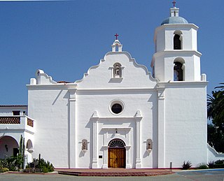
Mission San Luis Rey de Francia is a former Spanish mission in San Luis Rey, a neighborhood of Oceanside, California. This Mission lent its name to the Luiseño tribe of Mission Indians.
Merced County, is a county located in the northern San Joaquin Valley section of the Central Valley, in the U.S. state of California.

San Luis Obispo County, officially the County of San Luis Obispo, is a county on the Central Coast of California. As of the 2010 census, the population was 269,637. The county seat is San Luis Obispo.

Los Banos, alternatively Los Baños with the tilde on the ñ, is a city in Merced County, central California. It is located in the San Joaquin Valley, near the junction of State Route 152 and Interstate 5.

Pacheco Pass, elevation 1,368 ft (417 m), is a low mountain pass located in the Diablo Range in southeastern Santa Clara County, California. It is the main route through the hills separating the Santa Clara Valley and the Central Valley.

Central California is generally thought of as the middle third of the state, north of Southern California, which includes Los Angeles, and south of Northern California, which includes San Francisco. It includes the northern portion of the San Joaquin Valley, part of the Central Coast, the central hills of the California Coast Ranges and the foothills and mountain areas of the central Sierra Nevada.

San Luis Dam is a major earth-filled dam in Merced County, California, which forms San Luis Reservoir, the largest off-stream reservoir in the United States. The dam and reservoir are located in the Diablo Range to the east of Pacheco Pass and about 10 miles (16 km) west of Los Banos. San Luis Dam, a jointly-owned state and federal facility, stores more than 2 million acre feet of water for the California State Water Project and the federal Central Valley Project. Although the dam is located in the valley of San Luis Creek, the majority of its water comes from man-made aqueducts which are supplied from other rivers in Northern California.

The San Luis Reservoir is an artificial lake on San Luis Creek in the eastern slopes of the Diablo Range of Merced County, California, approximately 12 mi (19 km) west of Los Banos on State Route 152, which crosses Pacheco Pass and runs along its north shore. It is the fifth largest reservoir in California. The reservoir stores water taken from the San Joaquin-Sacramento River Delta. Water is pumped uphill into the reservoir from the O'Neill Forebay which is fed by the California Aqueduct and is released back into the forebay to continue downstream along the aqueduct as needed for farm irrigation and other uses. Depending on water levels, the reservoir is approximately nine miles long from north to south at its longest point, and five miles (8 km) wide. At the eastern end of the reservoir is the San Luis Dam, or the B.F. Sisk Dam, the fourth largest embankment dam in the United States, which allows for a total capacity of 2,041,000 acre feet (2,518,000 dam3). Pacheco State Park lies along its western shores.

Buildings, sites, districts, and objects in California listed on the National Register of Historic Places:

The California State Water Project, commonly known as the SWP, is a state water management project in the U.S. state of California under the supervision of the California Department of Water Resources. The SWP is one of the largest public water and power utilities in the world, providing drinking water for more than 23 million people and generating an average of 6,500 GWh of hydroelectricity annually. However, as it is the largest single consumer of power in the state itself, it has a net usage of 5,100 GWh.

Pacheco State Park is a California State Park to the south of Pacheco Pass in the Diablo Range, located mostly in western Merced County, California but extending into southeastern Santa Clara County and near Hollister in San Benito County. Located 24 miles (39 km) west of Los Banos, California and 20 miles (32 km) east of Gilroy, the park entrance is on Dinosaur Point Road, a short distance from California State Route 152 near Pacheco Pass. The park contains 6,890 acres (2,790 ha), though only the western 2,600 acres (1,100 ha) to the west are open to the public. The eastern two-thirds of the park are closed due to an underdeveloped trail system and safety concerns over the numerous wind turbines that are located in the Gonzaga Wind Farm that occupies the area. In 2018, it was announced that the 1980s-era turbines would be replaced with more efficient models, which would increase power production capacity from the original 16.5 megawatts (MW) to as much as 80 MW.

Santa Nella is a census-designated place in Merced County, California. It is located 11 miles (18 km) east-northeast of Pacheco Pass, at an elevation of 154 feet, At the 2010 census, Santa Nella had a population of 1,380 people.

Path 15 is an 84-mile (135 km) portion of the north-south power transmission corridor in California, U.S. It forms a part of the Pacific AC Intertie and the California-Oregon Transmission Project. Path 15 is part of The Western Electricity Coordinating Council's links of electrical intertie paths in the western United States.

This is a list of the National Register of Historic Places listings in Los Angeles, California.

This is a list of the National Register of Historic Places listings in San Luis Obispo County, California.

San Luis Creek, originally Arroyo de San Luis Gonzaga, is a stream in Merced County, California. Its source is located near the eastern crest of the Diablo Range, west of San Luis Reservoir. It is dammed to form San Luis Reservoir in San Luis Reservoir State Park, and below that, O'Neill Forebay. From the latter the creek continues east to its confluence with Los Banos Creek, 3.6 mi (5.8 km) east of Ingomar, California. Los Banos Creek is tributary to the San Joaquin River.
Poso de Chane or Poso Chane is a former settlement in Fresno County, California situated around the waterhole of that name, northwest just below the confluence of the Jacalitos Creek with Los Gatos Creek, 6 miles (9.7 km) east of Coalinga and northwest of the Guijarral Hills.
Los Baños Creek or Los Banos Creek, originally El Arroyo de los Baños, is a tributary stream of the San Joaquin River. Its source drains the slopes of the Diablo Range within the Central Valley of California, United States. Los Baños Creek has its source at the confluence of North Fork Los Banos Creek and South Fork Los Banos Creek. It flows northeast to the west edge of Los Banos and then north to Mud Slough 2.5 miles (4 km) upstream from its confluence with the San Joaquin River.

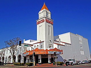
The Bank of Los Banos Building is a historic bank building located at 836–848 Sixth Street in Los Banos, California. Opened in 1925, the bank was designed to be a major business center in Los Banos, which lost most of its business district in a 1919 fire. The bank was built by Henry Miller and Charles Lux, prominent businessmen whose extensive holdings included land, cattle, and the San Joaquin and Kings River Canal and Irrigation Company. The building has a Neoclassical design which features wall surfaces resembling piers, a dentiled cornice, and seven bays on the front side, each containing a window or entrance. The original design also included a frieze decorated with cattle heads and garlands, though this was removed for safety reasons in the 1930s.
References
- 1 2 "National Register Information System". National Register of Historic Places . National Park Service. July 9, 2010.
- ↑ "Cultural Resources: California". United States Bureau of Reclamation . Retrieved April 11, 2013.
- ↑ Western Area Power Administration (1988). California-Oregon Transmission Project and the Los Banos-Gates Transmission Project: Environmental Impact Statement.
| Topics | |
|---|---|
| Lists by state |
|
| Lists by insular areas | |
| Lists by associated state | |
| Other areas | |
| Related | |
Municipalities and communities of Merced County, California, United States | ||
|---|---|---|
| Cities |  | |
| CDPs | ||
| Unincorporated communities | ||
| Ghost towns | ||
| | This article about a property in Merced County, California on the National Register of Historic Places is a stub. You can help Wikipedia by expanding it. |