San Saba is the 21st rione of Rome, Italy, identified by the initials R. XXI. It is located within the Municipio I, and takes its name from the Basilica of San Saba, which is located there.
The church of San Saba and the attached monastery, which after the fall of the Roman Empire have been for centuries the only populated settlement in the area, were built by some hermits between 7th and 9th century. The monastery soon became a powerful and lively institution, with many properties and an advanced diplomatic activity that made it influential in Constantinople and among the barbarians.
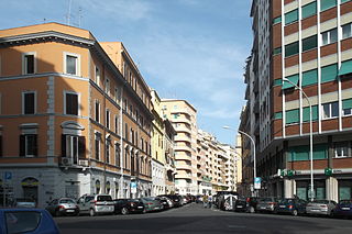
A view of some ICP houses
At the beginning of 20th century the church and the monastery were still surrounded by the countryside, and the 1909 town plan led to the urbanization of the area. Between 1907 and 1914 the Municipality commissioned the construction of a public housing complex for the clerical middle class, between the church and the Aurelian Walls to the Istituto Case Popolari. The planning was entrusted to the young architect Quadrio Pirani and the wide, tree-lined roads were named after prominent architects and artists. The public houses are semi-detached houses and little apartment blocks, with no more than 4 floors, each covered with bricks whose color evokes the ancient walls of the monastery.
Positioned on the level top of the Aventine Hill, the rione is crossed by rises and steps declining to the walls or to Testaccio.
Westward, the rione is separated from Testaccio (R. XX) by the portion of Via Marmorata between Piazzale Ostiense and Largo Manlio Gelsomini.
Odonymy
The rione revolves around a principal square Piazza Gian Lorenzo Bernini, which gathers all the elements that characterise an autonomous village, e.g. the elementary school, named after Leopoldo Franchetti, a park, a recreation ground and the nearby church, the market, several stores and a little theatre.
One of the main roads of San Saba is Viale Guido Baccelli, passing through the archaeological zone: it was named after the great physician and politician because of his dedication to the promotion of the archaeological area.
Other roads and squares are mostly named after artists and architects. Street names of the rione can be categorised as follows:
Local names, such as Via di San Saba, Via di Villa Pepoli and Viale Aventino;
Ripa is the 12th rione of Rome, Italy, identified by the initials R. XII, and it is located in the Municipio I.
Castro Pretorio is the 18th rione of Rome, Italy, identified by the initials R. XVIII, and it is located within the Municipio I. The rione takes its name by the ruins of the Castrum Praetorium, the barracks of the Praetorian Guard, included in the Aurelian Walls.
Celio is the 19th rione of Rome, Italy, identified by the initials R. XIX, and is located within the Municipio I.
Testaccio is the 20th rione of Rome, Italy, identified by the initials R. XX, deriving its name from Monte Testaccio. It is located within the Municipio I.
Circo Massimo is a station on Line B of the Rome Metro. It was opened on 10 February 1955 and is sited at the east end of the Circus Maximus, after which it is named, near the headquarters of the FAO, originally built as the Ministero delle Colonie. Until 2002, the Obelisk of Axum also stood near the station. It has two separate exits on either side of the viale Aventino.
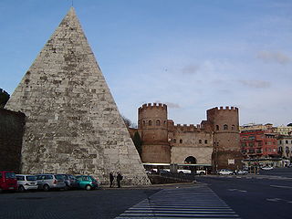
Piramide is a station on Line B of the Rome Metro. It was opened on 10 February 1955 and is sited on Piazzale Ostiense just outside Porta San Paolo, in the Ostiense quarter. Its atrium houses mosaics that have won the Artemetro Roma by Enrico Castellani (Italy) and Beverly Pepper. The station has escalators.
Roma Porta San Paolo is the terminal train station of the Rome–Lido railway line in Rome (Italy). The station is connected to the station Piramide of the metro and to the Roma Ostiense railway station of the Ferrovie dello Stato Italiane. It has six tracks.
Via Cristoforo Colombo is a street in Rome (Italy) that links the historic centre to Ostia. Along most of its route, the street has three lanes for each direction of movement. With its 27 kilometres (17 mi) length it is the longest Italian road among those included within the borders of a single municipality and, in several stretches, the largest in Italy.
Ostiense is the 10th quartiere of Rome, identified by the initials Q. X.
Portuense is the 11th quartiere of Rome (Italy), identified by the initials Q.XI.
Viale Aventino is a street that links Piazza di Porta Capena and Piazza Albania in Rome (Italy). It marks the boundary between the Rione Ripa and San Saba.
Pinciano is the 3rd quartiere of Rome (Italy), identified by the initials Q. III. The name derives from the Pincian Hill. It belongs to the Municipio II.
Nomentano is the 5th quartiere of Rome (Italy), identified by the initials Q. V. The name derives from the ancient road Via Nomentana. It belongs to the Municipio II.
Tiburtino is the 6th quartiere of Rome (Italy), identified by the initials Q. VI. The name derives from the ancient road Via Tiburtina. It belongs to the Municipio II, Municipio IV and Municipio V.
Prenestino-Labicano is the 7th quartiere of Rome (Italy), identified by the initials Q. VII. The name derives from the ancient roads Via Prenestina and Via Labicana, today the initial stretch of Via Casilina. It belongs to the Municipio V and Municipio VII.
Tuscolano is the 8th quartiere of Rome (Italy), identified by the initials Q. VIII. The name derives from the ancient road Via Tuscolana. It belongs to the Municipio V and Municipio VII.
Appio-Latino is the 9th quartiere of Rome (Italy), identified by the initials Q. IX. The name derives from the ancient roads Via Appia and Via Latina. It belongs to the Municipio VII and Municipio VIII.
Gianicolense is the 12th quartiere of Rome (Italy), identified by the initials Q. XII. It belongs to the Municipio XI and Municipio XII. It takes its name from the Janiculum hill, which lies in the nearby rione Trastevere and whose western extremities correspond to the area of Monteverde.
Aurelio is the 13th quartiere of Rome (Italy), identified by the initials Q. XIII. It belongs to the Municipio XIII and Municipio XIV.
Trionfale is the 14th quartiere of Rome (Italy), identified by the initials Q. XIV. The toponym also indicates the urban zone 19E of Municipio XIV.
This page is based on this Wikipedia article Text is available under the CC BY-SA 4.0 license; additional terms may apply. Images, videos and audio are available under their respective licenses.