San Vicente, Camarines Norte

Last updated
San Vicente
Municipality of San Vicente
Flag of San Vicente, Camarines Norte.png
Ph locator camarines norte san vicente.png
Map of Camarines Norte with San Vicente highlighted
OpenStreetMap
San Vicente, Camarines Norte
Philippines location map (square).svg
Red pog.svg
San Vicente
Location within the Philippines
Coordinates: 14°06′22″N122°52′24″E / 14.1061°N 122.8733°E / 14.1061; 122.8733
Country Philippines
Region Bicol Region
Province Camarines Norte
District 2nd district
Named for Saint Vincent Ferrer
Barangays 9 (see Barangays)
Government
[1]
  Type Sangguniang Bayan
   Mayor Ma. Jhoana C. Ong
   Vice Mayor Vivian M. Villamor
   Representative Rosemarie C. Panotes
   Municipal Council
Members
   Electorate 8,493 voters (2022)
Area
[2]
  Total57.49 km2 (22.20 sq mi)
Elevation
62 m (203 ft)
Highest elevation
672 m (2,205 ft)
Lowest elevation
6 m (20 ft)
Population
 (2020 census) [3]
  Total12,579
  Density220/km2 (570/sq mi)
   Households
2,858
Economy
   Income class 5th municipal income class
   Poverty incidence
27.21
% (2018) [4]
   Revenue 69.38 million (2020)
   Assets 185.8 million (2020)
   Expenditure 68.91 million (2020)
   Liabilities 82.51 million (2020)
Service provider
  ElectricityCamarines Norte Electric Cooperative (CANORECO)
Time zone UTC+8 (PST)
ZIP code
4609
PSGC
IDD : area code +63(0)54
Native languages Central Bikol
Tagalog

San Vicente, officially the Municipality of San Vicente (Tagalog : Bayan ng San Vicente), is a 5th class municipality in the province of Camarines Norte, Philippines. According to the 2020 census, it has a population of 12,579 people. [3]

Contents

Geography

Barangays

San Vicente is politically subdivided into 9 barangays. Each barangay consists of puroks and some have sitios.

Climate

Climate data for San Vicente, Camarines Norte
MonthJanFebMarAprMayJunJulAugSepOctNovDecYear
Average high °C (°F)26
(79)
26
(79)
28
(82)
30
(86)
30
(86)
29
(84)
28
(82)
28
(82)
28
(82)
28
(82)
27
(81)
26
(79)
28
(82)
Average low °C (°F)22
(72)
21
(70)
22
(72)
22
(72)
24
(75)
24
(75)
24
(75)
24
(75)
24
(75)
23
(73)
23
(73)
22
(72)
23
(73)
Average precipitation mm (inches)85
(3.3)
55
(2.2)
53
(2.1)
47
(1.9)
112
(4.4)
156
(6.1)
213
(8.4)
159
(6.3)
201
(7.9)
216
(8.5)
197
(7.8)
141
(5.6)
1,635
(64.5)
Average rainy days15.411.613.612.319.923.727.326.026.024.621.819.1241.3
Source: Meteoblue [6]

Demographics

Population census of San Vicente
YearPop.±% p.a.
1903 1,552    
1918 1,802+1.00%
1939 1,960+0.40%
1948 2,811+4.09%
1960 4,308+3.62%
1970 5,914+3.22%
1975 6,330+1.37%
1980 6,577+0.77%
1990 7,321+1.08%
1995 8,220+2.19%
2000 8,984+1.92%
2007 9,615+0.94%
2010 10,114+1.86%
2015 10,396+0.53%
2020 12,579+3.82%
Source: Philippine Statistics Authority [7] [8] [9] [10]

In the 2020 census, the population of San Vicente, Camarines Norte, was 12,579 people, [3] with a density of 220 inhabitants per square kilometre or 570 inhabitants per square mile.

Economy

Tourism

The Mananap Falls is approximately 20–25 ft tall, tucked inside the thick forest and mountains. The water was ice cold there is a small raft tied which will lead you near the falls and a ladder to get to the top of the falls. There is a jumping point as well. [18]

Related Research Articles

<span class="mw-page-title-main">Capalonga</span> Municipality in Camarines Norte, Philippines

Capalonga, officially the Municipality of Capalonga, is a 3rd class municipality in the province of Camarines Norte, Philippines. According to the 2020 census, it has a population of 36,223 people.

<span class="mw-page-title-main">Labo, Camarines Norte</span> Municipality in Camarines Norte, Philippines

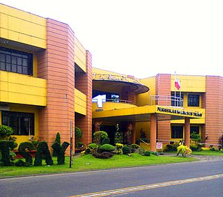
Labo, officially the Municipality of Labo, is a 1st class municipality in the province of Camarines Norte, Philippines. According to the 2020 census, it has a population of 109,245 people.

<span class="mw-page-title-main">Mercedes, Camarines Norte</span> Municipality in Camarines Norte, Philippines

Mercedes, officially the Municipality of Mercedes, is a 2nd class municipality in the province of Camarines Norte, Philippines. According to the 2020 census, it has a population of 55,334 people.

<span class="mw-page-title-main">San Lorenzo Ruiz, Camarines Norte</span> Municipality in Camarines Norte, Philippines

San Lorenzo Ruiz, officially the Municipality of San Lorenzo Ruiz, is a 5th class municipality in the province of Camarines Norte, Philippines. According to the 2020 census, it has a population of 15,757 people.

<span class="mw-page-title-main">Santa Elena, Camarines Norte</span> Municipality in Camarines Norte, Philippines

Santa Elena, officially the Municipality of Santa Elena, is a 3rd class municipality in the province of Camarines Norte, Philippines. According to the 2020 census, it has a population of 43,582 people.

<span class="mw-page-title-main">Talisay, Camarines Norte</span> Municipality in Camarines Norte, Philippines

Talisay, officially the Municipality of Talisay, is a 4th class municipality in the province of Camarines Norte, Philippines. According to the 2020 census, it has a population of 27,244 people.

<span class="mw-page-title-main">Vinzons</span> Municipality in Camarines Norte, Philippines

Vinzons, officially the Municipality of Vinzons, is a 3rd class municipality in the province of Camarines Norte, Philippines. According to the 2020 census, it has a population of 43,485 people.

<span class="mw-page-title-main">Baao</span> Municipality in Camarines Sur, Philippines

Baao, officially the Municipality of Baao is 1st class municipality in the province of Camarines Sur, Philippines. According to the 2020 census, it has a population of 61,493 people.

<span class="mw-page-title-main">Bato, Camarines Sur</span> Municipality in Camarines Sur, Philippines

Bato, officially the Municipality of Bato, is a 3rd class municipality in the province of Camarines Sur, Philippines. According to the 2020 census, it has a population of 52,155 people.

<span class="mw-page-title-main">Bula, Camarines Sur</span> Municipality in Camarines Sur, Philippines

Bula, officially the Municipality of Bula, is a 1st class municipality in the province of Camarines Sur, Philippines. According to the 2020 census, it has a population of 73,143 people.

<span class="mw-page-title-main">Garchitorena</span> Municipality in Camarines Sur, Philippines

Garchitorena, officially the Municipality of Garchitorena, is a 4th class municipality in the province of Camarines Sur, Philippines. According to the 2020 census, it has a population of 29,436 people.

<span class="mw-page-title-main">Lagonoy</span> Municipality in Camarines Sur, Philippines

Lagonoy, officially the Municipality of Lagonoy, is a 2nd class municipality in the province of Camarines Sur, Philippines. According to the 2020 census, it has a population of 56,714 people.

<span class="mw-page-title-main">Lupi, Camarines Sur</span> Municipality in Camarines Sur, Philippines

Lupi, officially the Municipality of Lupi, is a 3rd class municipality in the province of Camarines Sur, Philippines. According to the 2020 census, it has a population of 33,897 people.

<span class="mw-page-title-main">Minalabac</span> Municipality in Camarines Sur, Philippines

Minalabac, officially the Municipality of Minalabac, is a 2nd class municipality in the province of Camarines Sur, Philippines. According to the 2020 census, it has a population of 53,981 people.

<span class="mw-page-title-main">Ocampo, Camarines Sur</span> Municipality in Camarines Sur, Philippines

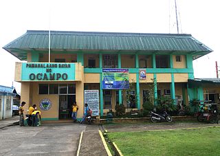
Ocampo, officially the Municipality of Ocampo, is a 1st class municipality in the province of Camarines Sur, Philippines. According to the 2020 census, it has a population of 51,073 people.

<span class="mw-page-title-main">Pamplona, Camarines Sur</span> Municipality in Camarines Sur, Philippines

Pamplona, officially the Municipality of Pamplona, is a 3rd class municipality in the province of Camarines Sur, Philippines. According to the 2020 census, it has a population of 39,333 people.

<span class="mw-page-title-main">Ragay</span> Municipality in Camarines Sur, Philippines

Ragay, officially the Municipality of Ragay, is a 1st class municipality in the province of Camarines Sur, Philippines. According to the 2020 census, it has a population of 59,770 people.

<span class="mw-page-title-main">Sagñay</span> Municipality in Camarines Sur, Philippines

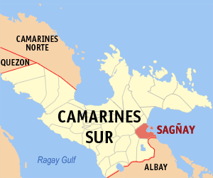
Sagñay, [ˈsaŋaj], officially the Municipality of Sagñay, is a 4th class municipality in the province of Camarines Sur in the Philippines. According to the 2020 census, it has a population of 36,841 people.

<span class="mw-page-title-main">Siruma</span> Municipality in Camarines Sur, Philippines

Siruma, officially the Municipality of Siruma, is a 4th class municipality in the province of Camarines Sur, Philippines. According to the 2020 census, it has a population of 19,419 people.

<span class="mw-page-title-main">Tinambac</span> Municipality in Camarines Sur, Philippines

Tinambac, officially the Municipality of Tinambac, is a 1st class municipality in the province of Camarines Sur, Philippines. According to the 2020 census, it has a population of 70,176 people.

References

  1. Municipality of San Vicente | (DILG)
  2. "2015 Census of Population, Report No. 3 – Population, Land Area, and Population Density" (PDF). Philippine Statistics Authority. Quezon City, Philippines. August 2016. ISSN   0117-1453. Archived (PDF) from the original on May 25, 2021. Retrieved July 16, 2021.
  3. 1 2 3 Census of Population (2020). "Region V (Bicol Region)". Total Population by Province, City, Municipality and Barangay. Philippine Statistics Authority . Retrieved 8 July 2021.
  4. "PSA Releases the 2018 Municipal and City Level Poverty Estimates". Philippine Statistics Authority. 15 December 2021. Retrieved 22 January 2022.
  5. "An Act Changing the Name of Barrio Iraya Norte in the Municipality of San Vicente, Province of Camarines Norte, to San Jose of the Said Municipality". LawPH.com. Retrieved 2011-04-11.
  6. "San Vicente, Camarines Norte: Average Temperatures and Rainfall". Meteoblue. Retrieved 27 December 2018.
  7. Census of Population (2015). "Region V (Bicol Region)". Total Population by Province, City, Municipality and Barangay. Philippine Statistics Authority . Retrieved 20 June 2016.
  8. Census of Population and Housing (2010). "Region V (Bicol Region)". Total Population by Province, City, Municipality and Barangay. National Statistics Office . Retrieved 29 June 2016.
  9. Censuses of Population (1903–2007). "Region V (Bicol Region)". Table 1. Population Enumerated in Various Censuses by Province/Highly Urbanized City: 1903 to 2007. National Statistics Office.
  10. "Province of Camarines Norte". Municipality Population Data. Local Water Utilities Administration Research Division. Retrieved 17 December 2016.
  11. "Poverty incidence (PI):". Philippine Statistics Authority. Retrieved December 28, 2020.
  12. Error: Unable to display the reference properly. See the documentation for details.
  13. Error: Unable to display the reference properly. See the documentation for details.
  14. Error: Unable to display the reference properly. See the documentation for details.
  15. Error: Unable to display the reference properly. See the documentation for details.
  16. Error: Unable to display the reference properly. See the documentation for details.
  17. "PSA Releases the 2018 Municipal and City Level Poverty Estimates". Philippine Statistics Authority. 15 December 2021. Retrieved 22 January 2022.
  18. "Trekking the Mananap Falls in San Vicente, Camarines Norte". www.carolranas.com. Retrieved 2017-10-01.