Sand Island Light (Alabama)

Last updated
Sand Island Light
Sandislandal1962 300.jpg
Sand Island lighthouse - 1962
Sand Island Light (Alabama)
Location Sand Island
Mobile County
Alabama
United States
Coordinates 30°11′16″N88°03′02″W / 30.18778°N 88.05056°W / 30.18778; -88.05056
Tower
Constructed1838 (first)
1859 (second)
1864 (third)
Foundationstone
Constructionbrownstone tower
Automated1948
Height131 feet (40 m)
Shapetapered cylindrical tower with balcony and lantern
Markingsunpainted tower, black lantern, and balcony
OperatorTown of Dauphin Island [1]
HeritageNational Register of Historic Places listed place  OOjs UI icon edit-ltr-progressive.svg
Fog signal bell struck every 20 seconds
Light
First lit1873 (current)
Deactivated1971
Focal height38 m (125 ft)  OOjs UI icon edit-ltr-progressive.svg
Lens1838: 14 lamps with 16-inch reflectors
1859: First order Fresnel lens
1862-63: Fourth order Fresnel lens
1873: Second order Fresnel lens, now at the Fort Morgan Museum
Range0 miles (0 km)
Characteristic F W
Sand Island Light
Nearest city Fort Morgan, Alabama
Arealess than one acre
Architectural styleItalianate
NRHP reference No. 75000305 [2]
Added to NRHPNovember 12, 1975

Sand Island Light, also known as Sand Island Lighthouse (and historical light station), is a decommissioned lighthouse located at the southernmost point of the state of Alabama, United States, near Dauphin Island, at the mouth of Mobile Bay, Alabama. It is located roughly 3 miles offshore from the primary Mobile Bay entrance, bounded on the east by Mobile Point and on the west by Dauphin Island. [3] The lighthouse is 132 feet (40 m) high.

Contents

History

The first lighthouse on Sand Island, constructed by Winslow Lewis in 1837, was a 55 feet (17 m) structure completed in 1839. The lighting was provided by 14 lamps in 16-inch reflectors and a first-order lens, known as the Lewis lamp, which was a poorly designed version, or Argand-style lamp. [4] Lewis enjoyed a monopoly through his relationship with Stephen Pleasonton that lasted until 1853. [5]

The light of the lighthouse Sandisland-light.jpg
The light of the lighthouse

In 1859 a new lighthouse was completed but was destroyed during the Civil War, on February 23, 1863, by Confederate John W. Glenn. After the Confederates at Fort Morgan observed U.S. Army soldiers in the lighthouse reconnoitering the fort, the guns of the fort fired upon the island, destroying the lighthouse. [3] In 1864 a 48 feet (15 m) wooden tower was built that lasted until 1873. [6]

Construction

By September 1864, the current lighthouse was completed, which included a two-story Lighthouse keepers dwelling, and the land at the time was approximately 400 acres (160 ha). The base is 28 feet (8.5 m) in diameter and 6 feet (1.8 m) thick, constructed on 171 interconnected wood pilings [7] covered with 12 feet (3.7 m) of concrete, and with a 125 feet (38 m) focal height. [8]

Issues

Sand Island faced continuous erosion to the point where granite blocks were being added to the island to try and stave off the deterioration and loss of the lighthouse. [3] Restoration efforts primarily stabilized the island through 2008. [3] Sand Island Lighthouse's dire situation is similar to its "sister light", the Morris Island Lighthouse, near Charleston, South Carolina. Both lighthouses were on eroded sandy islands, leaving the towers surrounded by water. [3]

Recent

In December 2011, the construction of a new island was completed. 1,400,000 yards (1,300,000 m) of sand was dredged from the sea floor and deposited around the lighthouse creating a 2,600 feet (790 m) by 500 feet (150 m), or approximately 15 acres (6.1 ha), island. [9] Less than a year later the $6,000,000 restoration of the island was washed away by Hurricane Isaac. [10]

The Dauphin Island Foundation (founded in 1991) works with the Alabama Lighthouse Association and acts as an agent and administrator for the Sand Island Restoration Project. There are seven general directors, nine directors at large, and also includes as directors: [11]

The Sand Island Lighthouse is on the Lighthouse Digest Doomsday List, as one of the most endangered lighthouses in the country, [12] It, and the Mobile Bay lighthouse, was damaged by Hurricane Ivan in 2004 and Hurricane Katrina in 2005. Repairing that damage will further delay restoration efforts. [12]

The image of this lighthouse was used as a stamp cancellation. [13]

See also

Related Research Articles

<span class="mw-page-title-main">Mobile Bay</span> Inlet of the Gulf of Mexico, lying within the state of Alabama in the United States

Mobile Bay is a shallow inlet of the Gulf of Mexico, lying within the state of Alabama in the United States. Its mouth is formed by the Fort Morgan Peninsula on the eastern side and Dauphin Island, a barrier island on the western side. The Mobile River and Tensaw River empty into the northern end of the bay, making it an estuary. Several smaller rivers also empty into the bay: Dog River, Deer River, and Fowl River on the western side of the bay, and Fish River on the eastern side. Mobile Bay is the fourth largest estuary in the United States with a discharge of 62,000 cubic feet (1,800 m3) of water per second. Annually, and often several times during the summer months, the fish and crustaceans will swarm the shallow coastline and shore of the bay. This event, appropriately named a jubilee, draws a large crowd because of the abundance of fresh, easily caught seafood.

<span class="mw-page-title-main">Dauphin Island, Alabama</span> Town in Alabama, United States

Dauphin Island is an island town in Mobile County, Alabama, United States, on a barrier island of the same name, in the Gulf of Mexico. It incorporated in 1988. The population was 1,778 at the 2020 census, up from 1,238 at the 2010 census. The town is part of the Mobile metropolitan area. The island was renamed for Louis XIV of France's great-grandson and heir, the dauphin, the future Louis XV of France. The name of the island is often mistaken as Dolphin Island; the word dauphin is French for dolphin, but historically, the term was used as the title of the heir apparent to the French monarch.

<span class="mw-page-title-main">Cordouan Lighthouse</span> Lighthouse in Gironde, France

Cordouan lighthouse is an active lighthouse located 7 kilometres at sea, near the mouth of the Gironde estuary in France. At a height of 67.5 metres (221 ft), it is the tenth-tallest "traditional lighthouse" in the world.

<span class="mw-page-title-main">Cape St. George Light</span> Lighthouse in Florida, US

The Cape St. George Light is a 72-foot (22 m) high brick lighthouse which had originally stood for 153 years on St. George Island, Florida, until toppling into the Gulf of Mexico October 22, 2005. The pieces of the lighthouse were retrieved, and in April 2008, the light's restoration was completed.

<span class="mw-page-title-main">Sand Key Light</span> Lighthouse southwest of Key West, Florida, United States

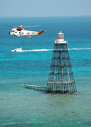
Sand Key Light is a lighthouse 6 nautical miles southwest of Key West, Florida, between Sand Key Channel and Rock Key Channel, two of the channels into Key West, on a reef intermittently covered by sand. At times the key has been substantial enough to have trees, and in 1900 nine to twelve thousand terns nested on the island. At other times the island has been washed away completely.

<span class="mw-page-title-main">Egmont Key Light</span> Lighthouse in Florida, United States

The current Egmont Key Light dates from 1858. It is the oldest structure in the Tampa Bay area still used for its original purpose.

<span class="mw-page-title-main">Cockspur Island Light</span> Lighthouse

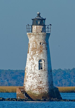
The Cockspur Island Light is the smallest lighthouse in Georgia. It ceased operation as an active beacon in 1909. It has been relit since 2007 for historical rather than navigational purposes.

Winslow Lewis was a sea captain, engineer, inventor and contractor active in the construction of many American lighthouses during the first half of the nineteenth century.

<span class="mw-page-title-main">Biloxi Lighthouse</span> Lighthouse in Mississippi, United States

Biloxi Lighthouse is a lighthouse in Biloxi, Mississippi, adjacent to the Mississippi Sound of the Gulf of Mexico. The lighthouse has been maintained by female keepers for more years than any other lighthouse in the United States. It was listed on the National Register of Historic Places in 1973 and declared a Mississippi Landmark in 1987.

<span class="mw-page-title-main">Middle Bay Light</span> Lighthouse

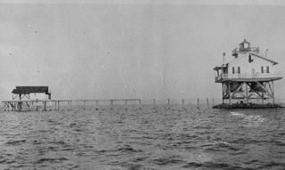
Middle Bay Light, also known as Middle Bay Lighthouse and Mobile Bay Lighthouse, is an active hexagonal-shaped cottage style screw-pile lighthouse. The structure is located offshore from Mobile, Alabama, in the center of Mobile Bay.

<span class="mw-page-title-main">Mobile Point Range Lights</span> Lighthouse

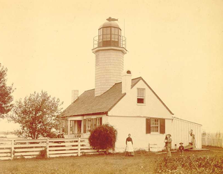
The Mobile Point Range Lights were a series of lighthouses at the entrance to Mobile Bay, at Mobile Point on the tip of the Fort Morgan peninsula, near Mobile, Alabama, United States. The first lighthouse was built as a landfall light by June 1822 at a cost of $9,995. The lighthouse was a conical brick masonry tower, 40 feet (12 m) tall. It was first lit on 29 September 1822. Fort Morgan was built adjacent to the lighthouse in 1833. The lighthouse was joined by the 200-foot (61 m) Sand Island Light across the mouth of the bay, about 3 miles (4.8 km) away in 1858. This resulted in the Mobile Point Lighthouse being downgraded to a harbor light, at the same time a fourth order Fresnel lens was installed. A period photograph, taken prior to the American Civil War, shows two shorter masonry towers standing on the beach below the main tower, they served as range lights. The lighthouse was subsequently destroyed by cannonball fire in the Battle of Mobile Bay during the Civil War.

<span class="mw-page-title-main">Chennai Lighthouse</span> Lighthouse in India

There have been at least four lighthouses named Chennai Lighthouse or Madras Lighthouse, which face the Bay of Bengal on the east coast of the Indian Subcontinent in Chennai, India.

<span class="mw-page-title-main">Greenbury Point Light</span> Lighthouse in Maryland, United States

Greenbury Point Light was the name of two lighthouses in the Chesapeake Bay, both located at the mouth of the Severn River in Annapolis, Maryland.

<span class="mw-page-title-main">Sand Point Light</span> Lighthouse in Michigan, United States

The Sand Point Lighthouse is located in Escanaba, Michigan, United States, on Lake Michigan's northern shore. Since 1989, it has been an unofficial aid to navigation. Though it is an operational aid to navigation. The restored lighthouse is now open to the public during the summer months. It is also known as the Escanaba/Sand Point Light or the Escanaba Light.

<span class="mw-page-title-main">Cat Island Light</span> Lighthouse

The Cat Island Light was a lighthouse located on Cat Island off the coast of Mississippi. Originally built to guide shipping through the Mississippi Sound, it was discontinued as traffic moved further south.

<span class="mw-page-title-main">Lange Jaap</span> Lighthouse

Lange Jaap, also known as Kijkduin Light or Den Helder Light, is an active lighthouse near Fort Kijkduin in Huisduinen, Netherlands. At a height of 63.5 metres (208.2 ft) it is one of the tallest "traditional lighthouses" in the world. For almost a century, from 1878 to 1974, it was the tallest lighthouse in the Netherlands, until the construction of the Maasvlakte Light. According to The Lighthouse Directory it is the tallest non-skeletal cast-iron lighthouse in the world.

<span class="mw-page-title-main">North Reef Light</span> Lighthouse

North Reef Light is an active lighthouse located on North Reef, a 5.6 square kilometres (2.2 sq mi) planar reef, about 120 kilometres (75 mi) northeast of Gladstone, Queensland, Australia in the Capricorn and Bunker Group. The lighthouse was constructed on a migratory patch of sand inside a fringing coral reef, which over the years disappeared and reappeared, as sand was washed away and accumulated, and is now a vegetated sandy island. Its construction is unique, having a hollow concrete base that both gives it resistance to the shifting nature of the sandbar and serves as a freshwater tank. As such, it is considered one of the major achievement in Australian lighthouse construction. It is also notable in that due to the harsh conditions, only bachelors were allowed to serve as lighthouse keepers. At 24 metres (79 ft) it is also the tallest of Queensland's timber-framed iron clad lighthouses.

References

  1. Rowlett, Russ. "Lighthouses of the United States: Alabama". The Lighthouse Directory. University of North Carolina at Chapel Hill . Retrieved 2016-06-06.
  2. "National Register Information System". National Register of Historic Places . National Park Service. July 9, 2010.
  3. 1 2 3 4 5 "Sand Island, AL". LighhouseFriends.com. Retrieved 22 April 2007.
  4. Argand & Lewis Lamps- Retrieved 2017-10-15
  5. Alabama Living: A history of Alabama's lighthouses, with vintage images of deactivated and existing lights- Retrieved 2017-10-15
  6. Alabama Lighthouse Association: Sand Island Lighthouse- Retrieved 2017-10-15
  7. Sand Island Lighthouse and drawing- Retrieved 2017-10-15
  8. Dauphin Island History: History Overboard!- Retrieved 2017-10-15
  9. Sand Island resurrected: Island is open to the public and tarball free- Retrieved 2017-10-15
  10. Sand Island, restored a year ago, disappears after Hurricane Isaac- Retrieved 2017-10-15
  11. Dauphin Island Foundation- Retrieved 2017-10-15
  12. 1 2 Rowlett, Russ. "Lighthouses of the United States: Alabama". The Lighthouse Directory. University of North Carolina at Chapel Hill.
  13. Lighthouse Stamp Society, Sand Island Light cancellation.

Further reading