Sand Lake, Sawyer County, Wisconsin

Last updated

Sand Lake, Wisconsin
Sand Lake WI.jpg
Sand Lake, WI from Highway 70
WIMap-doton-Sand Lake b.png
Location of Sand Lake, Sawyer County, Wisconsin
Coordinates: 45°50′27″N91°27′50″W / 45.84083°N 91.46389°W / 45.84083; -91.46389
Country Flag of the United States.svg  United States
State Flag of Wisconsin.svg  Wisconsin
County Sawyer
Area
  Total51.6 sq mi (133.5 km2)
  Land46.4 sq mi (120.1 km2)
  Water5.2 sq mi (13.4 km2)
Elevation
[1]
1,342 ft (409 m)
Population
 (2000)
  Total774
  Density16.7/sq mi (6.4/km2)
Time zone UTC-6 (Central (CST))
  Summer (DST) UTC-5 (CDT)
Area code(s) 715 & 534
FIPS code 55-71500 [2]
GNIS feature ID1584099 [1]

Sand Lake is a town in Sawyer County, Wisconsin, United States. The population was 774 at the 2000 census. The census-designated place of Stone Lake is located partially in the town. The unincorporated community of Hauer is also located in the town.

Contents

Geography

According to the United States Census Bureau, the town has a total area of 51.6 square miles (133.5 km2), of which, 46.4 square miles (120.1 km2) of it is land and 5.2 square miles (13.4 km2) of it (10.07%) is water.

Demographics

As of the census [2] of 2000, there were 774 people, 347 households, and 229 families residing in the town. The population density was 16.7 people per square mile (6.4/km2). There were 1,147 housing units at an average density of 24.7 per square mile (9.5/km2). The racial makeup of the town was 83.98% White, 14.86% Native American, 0.13% Asian, 0.26% from other races, and 0.78% from two or more races. Hispanic or Latino of any race were 0.65% of the population.

There were 347 households, out of which 18.2% had children under the age of 18 living with them, 55.3% were married couples living together, 6.9% had a female householder with no husband present, and 34.0% were non-families. 29.1% of all households were made up of individuals, and 14.7% had someone living alone who was 65 years of age or older. The average household size was 2.23 and the average family size was 2.70.

In the town, the population was spread out, with 18.5% under the age of 18, 6.6% from 18 to 24, 20.2% from 25 to 44, 30.0% from 45 to 64, and 24.8% who were 65 years of age or older. The median age was 49 years. For every 100 females, there were 112.1 males. For every 100 females age 18 and over, there were 110.3 males.

The median income for a household in the town was $32,266, and the median income for a family was $37,500. Males had a median income of $28,482 versus $25,714 for females. The per capita income for the town was $18,322. About 6.3% of families and 11.3% of the population were below the poverty line, including 11.4% of those under age 18 and 7.5% of those age 65 or over.

Related Research Articles

<span class="mw-page-title-main">Advance, Indiana</span> Town in Indiana, United States

Advance is a town in Jackson Township, Boone County, Indiana, United States. The population was 503 at the 2020 census.

<span class="mw-page-title-main">Ulen, Indiana</span> Town in Indiana, United States

Ulen is a town in Center Township, Boone County, in the U.S. state of Indiana. The population was 117 at the 2010 census. The town is surrounded by the city of Lebanon.

<span class="mw-page-title-main">Spiceland, Indiana</span> Town in Indiana, United States

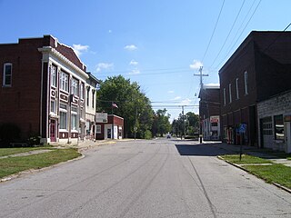
Spiceland is a town in Spiceland Township, Henry County, Indiana, United States. The population was 890 at the 2010 census.

<span class="mw-page-title-main">Penobscot, Maine</span> Town in the state of Maine, United States

Penobscot is a town in Hancock County, Maine, United States. The Bagaduce River flows through the town. The population was 1,136 at the 2020 census.

Greenwood is a town in Oxford County, Maine, United States. The population was 774 at the 2020 census. The town was named for surveyor Alexander Greenwood. The village of Locke Mills, on State Route 26 in the northern part of Greenwood, is the town's urban center and largest settlement.

Alton is a town in Penobscot County, Maine, United States. It is part of the Bangor Metropolitan Statistical Area. The population was 829 at the 2020 census. The community is named after an Alton in England.

<span class="mw-page-title-main">Thorndike, Maine</span> Town in the state of Maine, United States

Thorndike is a town in Waldo County, Maine, United States. The town was named after Israel Thorndike, a landowner. The population was 774 at the 2020 census.

<span class="mw-page-title-main">Friberg Township, Otter Tail County, Minnesota</span>

Friberg Township' is a township in Otter Tail County, Minnesota, United States. The population was 774 at the 2000 census.

<span class="mw-page-title-main">Ravenwood, Missouri</span> City in Missouri, United States

Ravenwood is a city in eastern Nodaway County, Missouri, United States, near the Platte River. The population was 439 at the 2020 census.

<span class="mw-page-title-main">Grantwood Village, Missouri</span> Town in Missouri, United States

Grantwood Village is a town in St. Louis County, Missouri, United States. The population was 863 at the 2010 census.

<span class="mw-page-title-main">Rich Creek, Virginia</span> Town in Virginia, United States

Rich Creek is a town in Giles County, Virginia, United States. The population was 774 as per the 2010 census, up from 665 as per the 2000 census. It is part of the Blacksburg–Christiansburg Metropolitan Statistical Area.

<span class="mw-page-title-main">Granger, Washington</span> City in Washington, United States

Granger is a city in Yakima County, Washington, United States. The population was 3,624 at the 2020 census. Although it was classified as a town in 2000, it has since been reclassified as a city.

<span class="mw-page-title-main">West Hamlin, West Virginia</span> Town in West Virginia, United States

West Hamlin is a town in Lincoln County, West Virginia, United States, along the Guyandotte River. The population was 519 at the 2020 census, and is now down to 509, according to the 2021 census. West Hamlin is a part of the Huntington-Ashland, WV-KY-OH, Metropolitan Statistical Area (MSA). West Hamlin is west of the county seat at Hamlin, hence the name.

<span class="mw-page-title-main">Athens, West Virginia</span> Town in West Virginia, United States

Athens is a town in Mercer County, West Virginia, United States. The population was 944 at the 2020 census. It is part of the Bluefield, WV-VA micropolitan area which has a population of 107,578. Athens is the home of Concord University.

<span class="mw-page-title-main">Reedy, West Virginia</span> Town in West Virginia, United States

Reedy is a town in Roane County, West Virginia, United States. The population was 152 at the 2020 census.

<span class="mw-page-title-main">Jackson, Burnett County, Wisconsin</span> Town in Wisconsin, United States

Jackson is a town in Burnett County in the U.S. state of Wisconsin. The population was 773 at the 2010 census.

<span class="mw-page-title-main">Lewiston, Wisconsin</span> Town in Wisconsin, United States

Lewiston is a town in Columbia County, Wisconsin, United States. The population was 1,187 at the 2000 census.

<span class="mw-page-title-main">Barre, Wisconsin</span> Town in Wisconsin, United States

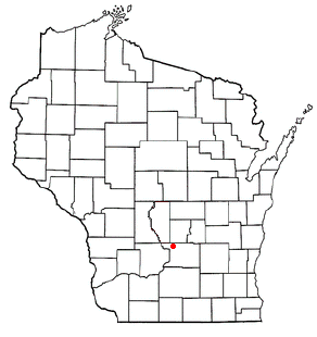
Barre is a town in La Crosse County, Wisconsin, United States. The population was 1,234 at the 2010 census. It is part of the La Crosse, Wisconsin Metropolitan Statistical Area. The town hall is in the unincorporated community of Barre Mills.

<span class="mw-page-title-main">McKinley, Polk County, Wisconsin</span> Town in Wisconsin, United States

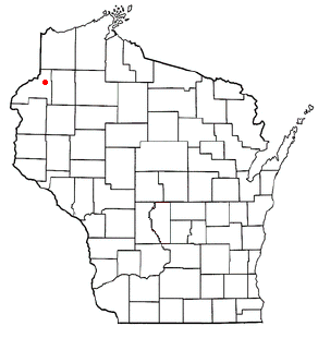
The Town of McKinley is located in Polk County, Wisconsin, United States. The population was 328 at the 2000 census.

<span class="mw-page-title-main">Trego, Wisconsin</span> Town in Wisconsin, United States

Trego is a town in Washburn County, Wisconsin. The population was 885 at the time of the 2000 census. The census-designated place of Trego is located in the town.

References

  1. 1 2 "US Board on Geographic Names". United States Geological Survey. October 25, 2007. Retrieved January 31, 2008.
  2. 1 2 "U.S. Census website". United States Census Bureau . Retrieved January 31, 2008.