Related Research Articles

Peter I Island is an uninhabited volcanic island in the Bellingshausen Sea, 450 kilometres (240 nmi) from continental Antarctica. It is claimed as a dependency of Norway and, along with Bouvet Island and Queen Maud Land, composes one of the three Norwegian dependent territories in the Antarctic and Subantarctic. The island measures approximately 11 by 19 kilometres, with an area of 156 km2 (60 sq mi); its highest point is the ultra-prominent, 1,640-metre-tall (5,380 ft) Lars Christensen Peak. Nearly all the island is covered by a glacier, and it is surrounded most of the year by pack ice, making it inaccessible during these times. There is little vertebrate animal life on the island apart from some seabirds and seals.
Signy Island is a small subantarctic island in the South Orkney Islands of Antarctica. It was named by the Norwegian whaler Petter Sørlle (1884–1933) after his wife, Signy Therese.

Thurston Island is an ice-covered, glacially dissected island, 215 km (134 mi) long, 90 km (56 mi) wide and 15,700 km2 (6,062 sq mi) in area, lying a short way off the northwest end of Ellsworth Land, Antarctica. It is the third largest island of Antarctica, after Alexander Island and Berkner Island.

Coronation Island is the largest of the South Orkney Islands, 25 nautical miles (46 km) long and from 3 to 8 nautical miles wide. The island extends in a general east–west direction, is mainly ice-covered and comprises numerous bays, glaciers and peaks, the highest rising to 1,265 metres (4,150 ft).
Trinity Island or Île de la Trinité or Isla Trinidad is an island 24 km (15 mi) long and 10 km (6 mi) wide in the northern part of the Palmer Archipelago, Antarctica. It lies 37 km (23 mi) east of Hoseason Island,72.6 km (45 mi) south of Deception Island in the South Shetland Islands, and 10.3 km (6 mi) north-northwest of Cape Andreas on the Antarctic Peninsula. The island was named by Otto Nordenskiöld, leader of the 1901-1904 Swedish Antarctic Expedition (SAE) in commemoration of Edward Bransfield's "Trinity Land" of 1820.

The Framnes Mountains are an Antarctic mountain range consisting of Casey Range, Masson Range, David Range, and Brown Range, and adjacent peaks and mountains. The three major ranges and other lesser features were sighted and named in February 1931 by the British Australian New Zealand Antarctic Research Expedition under Douglas Mawson. This coast was also sighted by Norwegian whalers in the same season. The whole area was mapped in detail by Norwegian cartographers from aerial photographs taken by the Lars Christensen Expedition in January 1937. This overall name for the several ranges was given by Lars Christensen after Framnesfjellet, a hill near Sandefjord, Norway.
Lützow-Holm Bay is a large bay, about 220 kilometres (120 nmi) wide, indenting the coast of Queen Maud Land in Antarctica between Riiser-Larsen Peninsula and the coastal angle immediately east of the Flatvaer Islands. It was discovered by Captain Hjalmar Riiser-Larsen in two airplane flights from his expedition vessel, the Norvegia, on February 21 and 23, 1931. The name honours Commander Finn Lützow-Holm of the Royal Norwegian Navy Air Service, a pilot for Captain Riiser-Larsen on the Aagaard in 1935.

King Haakon Bay, or King Haakon Sound, is an inlet on the southern coast of the island of South Georgia. The inlet is approximately 13 km long and 4 km wide. The inlet was named for King Haakon VII of Norway by Carl Anton Larsen, founder of Grytviken. Queen Maud Bay, named for his queen, is nearby. Shackleton Gap, a mountain pass, connects King Haakon Bay to Possession Bay.
Barff Peninsula is a peninsula forming the east margin of Cumberland East Bay, South Georgia Island. It is 8 miles (13 km) long and extends northwest from Sörling Valley to Barff Point, its farthest extremity. It was probably first seen by the British expedition under James Cook in 1775. The peninsula as a whole takes its name from Barff Point, which was named for Royal Navy Lieutenant A.D. Barff of HMS Sappho, who, assisted by Captain C.A. Larsen, sketched a map of Cumberland Bay in 1906. Barff Point is considered the eastern headland of East Cumberland Bay.
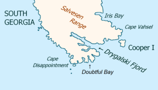
Drygalski Fjord is a bay 1 mile (1.6 km) wide which recedes northwestwards 7 miles (11 km), entered immediately north of Nattriss Head along the southeast coast of South Georgia. It was charted by the Second German Antarctic Expedition, 1911–12, under Wilhelm Filchner, and named for Professor Erich von Drygalski, the leader of the First German Antarctica Expedition, 1901–03.

Larsen Harbour is a narrow 2.6 miles (4.2 km) long inlet of indenting volcanic rocks and sheeted dykes known as the Larsen Harbour Formation. It is a branch of Drygalski Fjord, entered 2.5 miles (4 km) west-northwest of Nattriss Head, at the southeast end of South Georgia Island. It was charted by the Second German Antarctic Expedition, 1911–12, under Filchner, who named it for Captain Carl Anton Larsen a Norwegian explorer, who made significant contributions to the exploration of Antarctica. The most significant of these was the first discovery of fossils on the continent, for which he received the Back Grant from the Royal Geographical Society. Larsen is also considered the founder of the Antarctic whaling industry and the settlement and whaling station of Grytviken, South Georgia.
Cape Ingrid is a dark rock promontory separating Norvegia Bay and Sandefjord Cove on the west side of Peter I Island, Antarctica. It was discovered in 1927 by a Norwegian expedition under Eyvind Tofte in the Odd I, a vessel of Lars Christensen's whaling fleet, and named for Ingrid Christensen, the wife of Lars.
Cecil Cave is a sea cave which indents the southern part of Cape Ingrid on the west coast of Peter I Island in Antarctica. It was discovered and named by a Norwegian expedition under Eyvind Tofte in the Odd I in January 1927. Tofte and the second mate rowed into the cave in an unsuccessful attempt to land on the island.
Olstad Glacier is a heavily crevassed glacier descending to the west coast of Peter I Island about 2 nautical miles (3.7 km) south of Tofte Glacier. Peter I Island was circumnavigated by the Norwegian whale catcher Odd I in January 1927 and was explored from the Norvegia in February 1929.
Norvegia Bay is a cove at the north side of Cape Ingrid on the west side of Peter I Island. Named after the Norvegia, the Norwegian research vessel which visited the island in February 1929. The crew engaged in charting the island and in sounding and dredging operations.
Cape Eva is a cape forming the north end of Peter I Island. It was discovered and named in 1927 by a Norwegian expedition in the Odd I under Eyvind Tofte.

Cape Framnes is a cape which forms the northeast end of Jason Peninsula, on the east coast of Graham Land, Antarctica. It was discovered and named in 1893 by a Norwegian expedition under C.A. Larsen. The name is probably descriptive. Larsen reported that he gave the name Framnes to the promontory which shoots off in an eastern direction from "Mount Jason". He said it appeared to be the most advanced point of land which his expedition saw here.
Tvistein Pillars are two flat-topped pillar rocks standing 1 nautical mile (1.9 km) southwest of Cape Eva, the north extremity of Peter I Island, off the coast of Antarctica. The rocks were sighted from the Odd I by a Norwegian expedition under Eyvind Tofte in 1927. The name Tvistein was applied by a Norwegian expedition under Nils Larsen which charted the island from the Norvegia in 1929.
Tofte Glacier is a glacier immediately south of Sandefjord Cove on the west side of Peter I Island. Discovered in 1927 by a Norwegian expedition in the SS Odd I and named for Eyvind Tofte, leader of the expedition.
Ranvika is a cove on the east coast of Peter I Island, in the Bellingshausen Sea off the coast of the Antarctic.
References
- 1 2 3 Davis, Malcolm (1949). "Extension of Range of the Ringed Penguin". The Auk. 66 (1): 75–76. doi:10.2307/4080664. ISSN 0004-8038. JSTOR 4080664.
- ↑ "Sandefjord Cove". Geographic Names Information System . United States Geological Survey . Retrieved 6 June 2019.
- ↑ "Framnes Head". Geographic Names Information System . United States Geological Survey . Retrieved 5 April 2012.
![]() This article incorporates public domain material from websites or documents ofthe United States Geological Survey .
This article incorporates public domain material from websites or documents ofthe United States Geological Survey .
Coordinates: 68°47′S90°42′W / 68.783°S 90.700°W
| | This Ellsworth Land location article is a stub. You can help Wikipedia by expanding it. |