Sangerville, Maine

Last updated

Sangerville, Maine
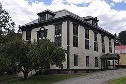
SangervilleME TownHall.jpg
Town hall
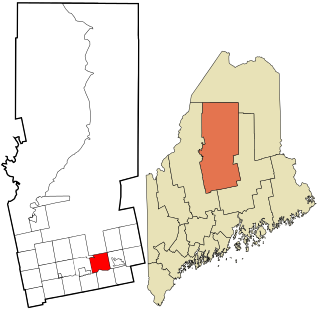
Piscataquis County Maine incorporated and unincorporated areas Sangerville highlighted.svg
Location in Piscataquis County and the state of Maine.
Coordinates: 45°7′26″N69°18′37″W / 45.12389°N 69.31028°W / 45.12389; -69.31028
Country United States
State Maine
County Piscataquis
Area
[1]
  Total39.72 sq mi (102.87 km2)
  Land38.42 sq mi (99.51 km2)
  Water1.30 sq mi (3.37 km2)
Elevation
505 ft (154 m)
Population
 (2020)
  Total1,306
  Density34/sq mi (13.1/km2)
Time zone UTC-5 (Eastern (EST))
  Summer (DST) UTC-4 (EDT)
ZIP code
04479
Area code 207
FIPS code 23-65865
GNIS feature ID0582713
Website sangervilleme.com

Sangerville is a town in Piscataquis County, Maine, United States. The population was 1,306 at the 2020 census. [2] The town was named after Colonel Calvin Sanger, a landowner. [3]

Contents

On June 14, 2014, Sangerville celebrated its bicentennial. [4]

Geography

According to the United States Census Bureau, the town has a total area of 39.72 square miles (102.87 km2), of which 38.42 square miles (99.51 km2) is land and 1.30 square miles (3.37 km2) is water. [1]

Climate

This climatic region is typified by large seasonal temperature differences, with warm to hot (and often humid) summers and cold (sometimes severely cold) winters. According to the Köppen Climate Classification system, Sangerville has a humid continental climate, abbreviated "Dfb" on climate maps. [5]

Climate data for Sangerville, Maine (1991–2020 normals, extremes 2009–present)
MonthJanFebMarAprMayJunJulAugSepOctNovDecYear
Record high °F (°C)53
(12)
59
(15)
82
(28)
86
(30)
92
(33)
96
(36)
93
(34)
91
(33)
93
(34)
84
(29)
71
(22)
58
(14)
96
(36)
Mean maximum °F (°C)48.0
(8.9)
46.4
(8.0)
57.4
(14.1)
72.2
(22.3)
81.8
(27.7)
86.6
(30.3)
90.5
(32.5)
87.3
(30.7)
84.9
(29.4)
73.5
(23.1)
62.8
(17.1)
51.3
(10.7)
91.8
(33.2)
Mean daily maximum °F (°C)26.6
(−3.0)
29.4
(−1.4)
38.9
(3.8)
51.1
(10.6)
63.8
(17.7)
72.7
(22.6)
78.6
(25.9)
77.8
(25.4)
70.3
(21.3)
56.9
(13.8)
43.6
(6.4)
31.6
(−0.2)
53.4
(11.9)
Daily mean °F (°C)16.9
(−8.4)
19.1
(−7.2)
28.7
(−1.8)
40.6
(4.8)
53.2
(11.8)
62.1
(16.7)
67.8
(19.9)
66.8
(19.3)
59.1
(15.1)
46.8
(8.2)
34.9
(1.6)
23.5
(−4.7)
43.3
(6.3)
Mean daily minimum °F (°C)7.2
(−13.8)
8.8
(−12.9)
18.4
(−7.6)
30.1
(−1.1)
42.5
(5.8)
51.4
(10.8)
57.0
(13.9)
55.7
(13.2)
47.8
(8.8)
36.6
(2.6)
26.3
(−3.2)
15.4
(−9.2)
33.1
(0.6)
Mean minimum °F (°C)−5.5
(−20.8)
−5.0
(−20.6)
0.5
(−17.5)
18.5
(−7.5)
30.7
(−0.7)
40.6
(4.8)
47.7
(8.7)
46.6
(8.1)
35.3
(1.8)
26.5
(−3.1)
12.8
(−10.7)
−0.1
(−17.8)
−9.0
(−22.8)
Record low °F (°C)−17
(−27)
−15
(−26)
−8
(−22)
8
(−13)
24
(−4)
33
(1)
42
(6)
42
(6)
31
(−1)
20
(−7)
0
(−18)
−16
(−27)
−17
(−27)
Average precipitation inches (mm)3.06
(78)
2.58
(66)
3.06
(78)
3.61
(92)
3.76
(96)
4.43
(113)
3.45
(88)
3.56
(90)
3.54
(90)
4.81
(122)
3.61
(92)
3.40
(86)
42.87
(1,089)
Average snowfall inches (cm)16.5
(42)
21.9
(56)
14.3
(36)
5.1
(13)
0.0
(0.0)
0.0
(0.0)
0.0
(0.0)
0.0
(0.0)
0.0
(0.0)
1.7
(4.3)
7.6
(19)
23.7
(60)
90.8
(231)
Average precipitation days (≥ 0.01 in)8.38.38.611.511.913.412.011.69.012.69.811.6128.6
Average snowy days (≥ 0.1 in)7.97.35.11.70.00.00.00.00.01.03.38.735
Source: NOAA [6] [7]

Demographics

Historical population
CensusPop.Note
1820 310
1830 776150.3%
1840 1,19754.3%
1850 1,2675.8%
1860 1,3143.7%
1870 1,140−13.2%
1880 1,047−8.2%
1890 1,23618.1%
1900 1,2944.7%
1910 1,3191.9%
1920 1,246−5.5%
1930 1,225−1.7%
1940 1,194−2.5%
1950 1,161−2.8%
1960 1,157−0.3%
1970 1,107−4.3%
1980 1,21910.1%
1990 1,39814.7%
2000 1,270−9.2%
2010 1,3435.7%
2020 1,306−2.8%
U.S. Decennial Census [8]

2010 census

As of the census [9] of 2010, there were 1,343 people, 612 households, and 402 families living in the town. The population density was 35.0 inhabitants per square mile (13.5/km2). There were 886 housing units at an average density of 23.1 per square mile (8.9/km2). The racial makeup of the town was 96.8% White, 0.4% African American, 1.1% Native American, 0.2% Asian, 0.1% from other races, and 1.3% from two or more races. Hispanic or Latino of any race were 0.4% of the population.

There were 613 households, of which 23.3% had children under the age of 18 living with them, 52.4% were married couples living together, 7.2% had a female householder with no husband present, 6.0% had a male householder with no wife present, and 34.4% were non-families. 28.9% of all households were made up of individuals, and 14.1% had someone living alone who was 65 years of age or older. The average household size was 2.19 and the average family size was 2.61.

The median age in the town was 48.6 years. 18.2% of residents were under the age of 18; 6% were between the ages of 18 and 24; 19.8% were from 25 to 44; 35.7% were from 45 to 64; and 20.3% were 65 years of age or older. The gender makeup of the town was 48.3% male and 51.7% female.

2000 census

As of the census [10] of 2000, there were 1,270 people, 554 households, and 361 families living in the town. The population density was 33.0 inhabitants per square mile (12.7/km2). There were 787 housing units at an average density of 20.4 per square mile (7.9/km2). The racial makeup of the town was 98.35% White, 0.55% African American, 0.47% Native American, 0.16% Asian, and 0.47% from two or more races. Hispanic or Latino of any race were 0.39% of the population.

There were 554 households, out of which 26.4% had children under the age of 18 living with them, 53.1% were married couples living together, 8.5% had a female householder with no husband present, and 34.8% were non-families. 29.2% of all households were made up of individuals, and 14.3% had someone living alone who was 65 years of age or older. The average household size was 2.29 and the average family size was 2.80.

In the town, the population was spread out, with 22.0% under the age of 18, 5.4% from 18 to 24, 26.6% from 25 to 44, 28.8% from 45 to 64, and 17.2% who were 65 years of age or older. The median age was 42 years. For every 100 females, there were 101.3 males. For every 100 females age 18 and over, there were 99.0 males.

The median income for a household in the town was $28,036, and the median income for a family was $35,809. Males had a median income of $26,518 versus $19,353 for females. The per capita income for the town was $13,984. About 8.7% of families and 11.5% of the population were below the poverty line, including 12.5% of those under age 18 and 17.2% of those age 65 or over.

Notable people

Related Research Articles

<span class="mw-page-title-main">Piscataquis County, Maine</span> County in Maine, United States

Piscataquis County is a county located in the U.S. state of Maine. As of the 2020 census, its population was 16,800, making it Maine's least-populous county. Its county seat is Dover-Foxcroft. The county was incorporated on March 23, 1838, taken from the western part of Penobscot County and the eastern part of Somerset County. It is named for an Abenaki word meaning "branch of the river" or "at the river branch."

<span class="mw-page-title-main">New Limerick, Maine</span> Town in the state of Maine, United States

New Limerick is a town in Aroostook County, Maine, United States. The population was 574 at the 2020 census. The town was settled in 1775 and incorporated on March 18, 1837, from New Limerick Plantation. It received its name from the fact that many of its settlers had previously lived in Limerick in York County at the southern end of the state, which in turn was probably named after the Irish city of Limerick.

<span class="mw-page-title-main">Hartford, Maine</span> Town in the state of Maine, United States

Hartford is a town in Oxford County, Maine, United States. Hartford is included in the Lewiston-Auburn, Maine metropolitan New England City and Town Area. The population was 1,203 at the 2020 census.

<span class="mw-page-title-main">Abbot, Maine</span> Town in the state of Maine, United States

Abbot is a town in Piscataquis County, Maine, United States. The population was 650 at the 2020 census. It was named for the treasurer of Bowdoin College, John Abbot.

<span class="mw-page-title-main">Bowerbank, Maine</span> Town in the state of Maine, United States

Bowerbank is a town in Piscataquis County, Maine, United States. The population was 136 at the 2020 census.

<span class="mw-page-title-main">Lake View Plantation, Maine</span> Plantation in Maine, United States

Lake View is a plantation in Piscataquis County, Maine, United States. The population was 150 at the 2020 census.

<span class="mw-page-title-main">Medford, Maine</span> Town in the state of Maine, United States

Medford is a town in Piscataquis County, Maine, United States. The population was 230 at the 2020 census.

<span class="mw-page-title-main">Parkman, Maine</span> Town in the state of Maine, United States

Parkman is a town in Piscataquis County, Maine, United States. The population was 747 at the 2020 census.
<span class="mw-page-title-main">Sebec, Maine</span> Town in the state of Maine, United States

Sebec is a town in Piscataquis County, Maine, United States. The population was 665 at the 2020 census.

<span class="mw-page-title-main">Shirley, Maine</span> Town in the state of Maine, United States

Shirley is a town in Piscataquis County, Maine, United States. The town was named after Shirley, Massachusetts. The population was 251 at the 2020 census. It was the birthplace of humorist Bill Nye.

<span class="mw-page-title-main">Wellington, Maine</span> Town in the state of Maine, United States

Wellington is a town in Piscataquis County, Maine, United States. The town was named for Arthur Wellesley, 1st Duke of Wellington. The population was 229 at the 2020 census.

<span class="mw-page-title-main">Willimantic, Maine</span> Town in the state of Maine, United States

Willimantic is a town in Piscataquis County, Maine, United States. The population was 134 according to the 2020 census.

Athens is a town in Somerset County, Maine, United States. The population was 952 at the 2020 census.

<span class="mw-page-title-main">Northeast Piscataquis, Maine</span> Unorganized territory in Maine, United States

Northeast Piscataquis is an unincorporated area in Piscataquis County, Maine, United States. The population was 304 at the 2020 census.

Howland is a town in Penobscot County, Maine, United States, which was settled in 1818. It was named after John Howland, one of the passengers on the Mayflower. The population was 1,094 at the 2020 census.

<span class="mw-page-title-main">Greenville, Maine</span> Town in the state of Maine, United States

Greenville is a town in Piscataquis County, Maine, United States. The population was 1,437 at the 2020 census. The town is centered on the lower end of Moosehead Lake, the largest body of fresh water in the state. Greenville is the historic gateway to the north country and a center for outdoor recreation in the area. Greenville High School, with 89 students, was ranked as the third best high school in Maine and one of the top 1,000 in the US in 2010.

<span class="mw-page-title-main">Van Buren, Maine</span> Town in Maine, United States

Van Buren is a town on the Saint John River in Aroostook County, Maine, United States; located across from Saint-Leonard, New Brunswick, Canada. The population was 2,038 at the 2020 census. It is named after U.S. President Martin Van Buren.

<span class="mw-page-title-main">Dover-Foxcroft, Maine</span> Town in Maine, United States

Dover-Foxcroft is the largest town in and the seat of Piscataquis County, Maine, United States. The population was 4,422 at the 2020 census. The town is located near the geographic center of the state.

<span class="mw-page-title-main">Greenville (CDP), Maine</span> CDP in Maine, United States

Greenville is a census-designated place (CDP) in the town of Greenville in Piscataquis County, Maine, United States. The population was 1,010 at the 2020 census.

<span class="mw-page-title-main">Guilford, Maine</span> Town in the state of Maine, United States

Guilford is a town in Piscataquis County, Maine, United States. The town is located on the Piscataquis River and was first settled in 1806. The population was 1,267 at the time of the 2020 census.
References

  1. 1 2 "US Gazetteer files 2010". United States Census Bureau . Retrieved December 16, 2012.
  2. "Census - Geography Profile: Sangerville town, Piscataquis County, Maine" . Retrieved January 21, 2022.
  3. "Profile for Sangerville, Maine". ePodunk . Retrieved May 7, 2010.
  4. Krinjak, John (June 14, 2014). "Sangerville Celebrates 200th Birthday" . Retrieved April 14, 2017.
  5. "Sangerville, Maine Köppen Climate Classification (Weatherbase)" . Retrieved April 14, 2017.
  6. "NOWData – NOAA Online Weather Data". National Oceanic and Atmospheric Administration. Retrieved August 18, 2022.
  7. "U.S. Climate Normals Quick Access – Station: E Sangerville, ME". National Oceanic and Atmospheric Administration. Retrieved December 30, 2022.
  8. "Census of Population and Housing". Census.gov. Retrieved June 4, 2015.
  9. "U.S. Census website". United States Census Bureau . Retrieved December 16, 2012.
  10. "U.S. Census website". United States Census Bureau . Retrieved January 31, 2008.
  11. "Hiram Stevens Maxim". Grace’s Guide. Retrieved December 6, 2013.


45°09′53″N69°21′23″W / 45.16472°N 69.35639°W / 45.16472; -69.35639