Sar Pass Trek

Last updated

Sar Pass
Mountain Pass
India Himachal Pradesh location map.svg
Red pog.svg
Sar Pass
India location map.svg
Red pog.svg
Sar Pass
Coordinates: 32°04′12″N77°23′18″E / 32.07°N 77.388455°E / 32.07; 77.388455
CountryIndia
State Himachal Pradesh
District Kullu
Elevation
4,220 m (13,850 ft)
Languages
  Official Hindi
  Regional Kulvi
Frozen Lake - Sar Sar-lake.jpg
Frozen Lake - Sar
Sar Pass Top as seen from Sar Pass in Kullu district of Himachal Pradesh, India Sar Pass Top as seen from Sar Pass I IMG 7176.jpg
Sar Pass Top as seen from Sar Pass in Kullu district of Himachal Pradesh, India

The Sar Pass is in Parvati Valley of Kullu district of Himachal Pradesh, a state of India.

Contents

Sar, in the local dialect, means a lake. While trekking across the path from Tila Lotni to Biskeri Ridge, one has to pass by a small, usually frozen lake (Sar) and hence the name Sar Pass Trek.

On way to Sar Pass - colours of the morning On way to Sar Pass- colours of the morning I IMG 7133.jpg
On way to Sar Pass - colours of the morning
This is at 13,800 feet above sea level Sar Pass top.jpg
This is at 13,800 feet above sea level

How To Reach

Air

The nearest airport Bhuntar Airport (IATA code KUU) is at Bhuntar town, situated on NH21 about 32.3 km (20.1 mi) south of Rumsu and 10 km (6.2 mi) south of Kullu town. The airport is also known as Kullu-Manali airport and has more than a kilometre long runway. Air India and some private airlines have regular flights to the airport. Recently Himalayan Bulls in collaboration with Deccan Charters have started flights on Kullu-Chandigarh-Kullu sector three times a day. Daily flight service (except Tuesday) has been started by 15 May 2013 at Bhunter airport by Air India from Delhi to Bhuntar and vice versa. Chandigarh Airport is the nearest international airport.

Road

Kasol is 30 km from Bhunter, and Bhunter can be reached from Delhi by national highway NH 1 up to Ambala and from there NH 22 to Chandigarh and from there by national highway NH21 that passes through Bilaspur, Sundernagar, Mandi and Kullu towns. The road distance from Chandigarh to Manali is 316 km (196 mi), and the total distance from Delhi to Manali is 566 km (352 mi). Buses (including Volvo and Mercedes Benz) on this route are available from all major bus terminals.

Rail

Kasol is not easily approachable by rail. The nearest broad gauge railheads are at Chandigarh (275 km (171 mi)), Pathankot (325 km (202 mi)) and Kalka (310 km (193 mi)). The nearest narrow gauge railhead is at Joginder Nagar (135 kilometres (84 mi)).

See Bhanupli–Leh line for the proposed railway line through this area.

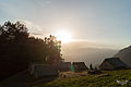
View from Nagaru Camp (12,500ft)

Nagaru Panoramic View.jpg
View from Nagaru

See also

Related Research Articles

<span class="mw-page-title-main">Kullu district</span> District of Himachal Pradesh, India

Kullu is a district in Himachal Pradesh, India. It borders Shimla district to the south, Mandi and Kangra districts to the west, Kinnaur to the east and the Lahaul and Spiti district to the north and east. The largest valley in this mountainous district is the Kullu Valley. The Kullu valley follows the course of the Beas River, and ranges from an elevation of 833 m above sea level at Aut to 3330 m above sea level at the Atal Tunnel South Portal, below the Rohtang Pass. The town of Kullu, located on the right side of the Beas River, serves as the administrative headquarters of the Kullu district. The Kullu district also incorporates several riverine tributary valleys of the Beas, including those of the Parvati, Sainj, and Tirthan rivers, and thus some regions somewhat distant from the Kullu valley. The economy of the district relies mainly on horticulture, agriculture, tourism, and traditional handicrafts.

<span class="mw-page-title-main">Manali, Himachal Pradesh</span> Town in India

Manali is a town, near Kullu town in Kullu district in the Indian state of Himachal Pradesh. It is situated in the northern end of the Kullu Valley, formed by the Beas River. The town is located in the Kullu district, approximately 270 kilometres (170 mi) north of the state capital of Shimla and 544 kilometres (338 mi) northeast of the national capital of New Delhi. With a population of 8,096 people recorded in the 2011 Indian census Manali is the beginning of an ancient trade route through Lahaul (H.P) and Ladakh, over the Karakoram Pass and onto Yarkand and Hotan in the Tarim Basin of China. Manali is a popular tourist destination in India and serves as the gateway to the Lahaul and Spiti district as well as the city of Leh in Ladakh.

<span class="mw-page-title-main">Kyelang</span> Town in Himachal Pradesh, India

Kyelang is a town and the administrative centre of the Lahaul and Spiti district in the Indian state of Himachal Pradesh, 71 kilometres (44 mi) north of Manali via Atal Tunnel and 120 km (75 mi) from the Indo-Tibetan border. It is located along the Manali-Leh Highway, about 7 km northeast of intersection of the Chandra, Bhaga, and Chenab valleys, on the banks of Bhaga River.

<span class="mw-page-title-main">Kullu</span> Town in Himachel Pradesh, India

Kullu is a municipal council town that serves as the administrative headquarters of the Kullu district of the Indian state of Himachal Pradesh. It is located on the banks of the Beas River in the Kullu Valley about 10 kilometres (6.2 mi) north of the airport at Bhuntar, Kullu.

<span class="mw-page-title-main">Naggar, Himachal Pradesh</span> Town in Himachal Pradesh

Situated on the left bank of river Beas at an altitude of 1,800 meters, Naggar is an ancient town in Kullu district of Himachal Pradesh, India. It was once capital of the Kullu kingdom.

<span class="mw-page-title-main">Bhuntar</span> Town in Himachal Pradesh, India

Bhuntar is a town and a nagar panchayat in Kullu district in the state of Himachal Pradesh, India. It is just 11 km from Kullu town, and lies along National Highway 3. The Kullu Airport is located in Bhuntar. Bhuntar is located on the right bank of the Beas River. Right opposite to Bhuntar, near the left bank of the Beas River, there is the confluence of the Parvati River with the River Beas. The Parvati Valley begins at this confluence and runs eastward, through a steep-sided valley towards Kasol and Manikaran.

Nurpur is a city and a municipal council in Kangra district in the Indian state of Himachal Pradesh. It was formerly part of the Nurpur State since the 11th century AD. The capital of the state was at Pathankot formerly known as Paithan, now in Punjab.It got its name from wife of Mughal emperor Jahangir, Nur Jahan, when they visited Kangra (Nagarkot) after Jahangir's successful conquest of the Kangra Fort.

<span class="mw-page-title-main">Sundar Nagar</span> A town in Himachal Pradesh, India

Sundar Nagar is a town and a municipal council in Mandi district in the Indian state of Himachal Pradesh. It was formerly a princely state, known as Suket.

Raison is a stopover which has vast camping grounds maintained by Himachal Pradesh Tourism.

<span class="mw-page-title-main">Jogindernagar</span> Municipality and Hill Station in Himachal Pradesh, India

Jogindernagar, or Jogindar Nagar, is a municipality, and a sub district in Mandi district in the Indian state of Himachal Pradesh. Named after Raja Joginder Sen, the hill station is the terminus of the 163-kilometre-long (101 mi) Kangra Valley narrow-gauge railway. Jogindernagar is the third-largest city in the Mandi district. The only city in Asia with three hydro-electric power stations, its nickname is "The City of Powerhouses".

The Kanwar Sanctuary is located in Parbati valley of Kullu district. R.O. wildlife Kasol provides information and help to visitors. Uphill walk along Garahan Nala from Kasol through dense Deodar and Fir forests is worth. The sanctuary has large population of Himalayan Tahr.

Himachal Pradesh, although railways and airways serve very limited transport needs, the road network of the state serves the transport needs of the people. Although, the geography of Himachal presents considerable challenge to the development of transport infrastructure, it has the highest road density among all the Hill States of India. Himachal also has 3 airports, 2 narrow gauge rail tracks and couple of other under-construction broad gauge railway tracks, but roads remain the main mode of transport.

<span class="mw-page-title-main">Saurkundi Pass Trek</span>

The Saurkundi Pass Trek is a hiking trail in the Kullu district of Himachal Pradesh, a state of northern India. The trek is an 11-day program and participants hike every day during the period. The groups range from 40 to 50 persons. The trail starts at Babeli, the base camp, and passes through scenic spots in the Kullu valley.

<span class="mw-page-title-main">Kullu–Manali Airport</span> Domestic airport in Kullu, Himachal Pradesh, India

Kullu–Manali Airport, also called Bhuntar Airport is a domestic airport serving the cities of Kullu and Manali in the Indian state of Himachal Pradesh. The airport is located at Bhuntar, 11 km from Kullu town and 52 km from Manali.

<span class="mw-page-title-main">Sissu</span> Town in Himachal Pradesh, India

Sissu is a small town in the Lahaul valley of Himachal Pradesh in India. It is around 40 km from Manali and located on the right bank of Chandra river. It is located at 32°29′0″N77°7′0″E. It is 3,120 m above sea level. It is 14 km from Koksar to the south-east and 11 km. west to Gondhla.

<span class="mw-page-title-main">Kasol</span> Hill Station in Himachal Pradesh, India

Kasol is a hamlet in the Kullu district of the Indian state of Himachal Pradesh. It is situated in Parvati Valley, on the banks of the Parvati River between Bhuntar and Manikaran. It is located 30 km (19 mi) from Bhuntar, 3.5 km from Manikaran and 36 km (22 mi) from Kullu town, the district headquarters. Kasol is the Himalayan hotspot for backpackers and acts as a base for nearby treks to Malana and Kheerganga. It is called Mini Israel of India due to a high percentage of Israeli tourists here.

<span class="mw-page-title-main">Mandi, Himachal Pradesh</span> A city in Himachal Pradesh, India

Mandi is a major city and a municipal corporation in Mandi District in the Indian state of Himachal Pradesh. It is situated 145 kilometres (90 mi) north of state capital, Shimla in the north-west Himalayas at an average altitude of 880 m (2,890 ft) Mandi is connected to the Pathankot through National Highway 20 and to Manali and Chandigarh through National Highway 21. Mandi is approximately 184.6 km (114.7 mi) from Chandigarh, the nearest major city, and 440.9 km (274.0 mi) from New Delhi, the national capital. In the 2011 Indian census, Mandi city had a population of 26,422. Mandi district is currently the 4th largest economy in the state. Mandi has the second highest sex ratio of 1013 females per thousand males, in the state.

<span class="mw-page-title-main">Himachal Road Transport Corporation</span> State owned road Transport Corporation of Himachal Pradesh

Himachal Road Transport Corporation, also referred to as HRTC, is the state-owned road transport corporation of the state of Himachal Pradesh, India. HRTC provides bus services to towns and cities within Himachal Pradesh and the adjoining and nearby states of Uttarakhand, Punjab, Haryana, Delhi, Uttar Pradesh, Jammu and Kashmir and Rajasthan. HRTC is one of the first RTC's in India to offer a facility for online booking of tickets for all types of buses.

<span class="mw-page-title-main">Tourism in Himachal Pradesh</span> Tourism in the Indian state of Himachal Pradesh

Tourism in Himachal Pradesh relates to tourism in the Indian state of Himachal Pradesh. This is popularly renowned for its Himalayan landscapes and popular hill-stations. Many outdoor activities such as rock climbing, mountain biking, paragliding, ice-skating, trekking, rafting, and heli-skiing are popular tourist attractions in Himachal Pradesh.

Chanderkhani Pass is a pass located in the Kullu District of India at a height of 3,660 metres. It forms a way (pass) between the villages of Rumsu and Pulag to the well known village of Malana, which indirectly forms a trekking route from Naggar to Malana across the Chanderkhani Pass.

References