
Taiga or tayga, also known as boreal forest or snow forest, is a biome characterized by coniferous forests consisting mostly of pines, spruces, and larches. The taiga or boreal forest is the world's largest land biome. In North America, it covers most of inland Canada, Alaska, and parts of the northern contiguous United States. In Eurasia, it covers most of Sweden, Finland, much of Russia from Karelia in the west to the Pacific Ocean, much of Norway and Estonia, some of the Scottish Highlands, some lowland/coastal areas of Iceland, and areas of northern Kazakhstan, northern Mongolia, and northern Japan.

The Palearctic or Palaearctic is the largest of the eight biogeographic realms of the Earth. It stretches across all of Eurasia north of the foothills of the Himalayas, and North Africa.
The Global 200 is the list of ecoregions identified by the World Wide Fund for Nature (WWF), the global conservation organization, as priorities for conservation. According to WWF, an ecoregion is defined as a "relatively large unit of land or water containing a characteristic set of natural communities that share a large majority of their species dynamics, and environmental conditions". For example, based on their levels of endemism, Madagascar gets multiple listings, ancient Lake Baikal gets one, and the North American Great Lakes get none.

Temperate broadleaf and mixed forest is a temperate climate terrestrial habitat type defined by the World Wide Fund for Nature, with broadleaf tree ecoregions, and with conifer and broadleaf tree mixed coniferous forest ecoregions.

Temperate rainforests are rainforests with coniferous or broadleaf forests that occur in the temperate zone and receive heavy rain.

The Scandinavian coastal conifer forests or Norwegian coastal conifer forest is a Palearctic ecoregion in the temperate coniferous forests biome, located along the coast of Norway. Within it are a number of small areas with botanical features and a local climate consistent with a temperate rainforest.

The Scandinavian montane birch forests and grasslands is defined by the World Wildlife Fund (WWF) as a terrestrial tundra ecoregion in Norway, Sweden, and Finland.

A forest steppe is a temperate-climate ecotone and habitat type composed of grassland interspersed with areas of woodland or forest.

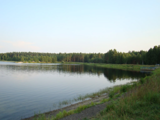
The Scandinavian and Russian taiga is an ecoregion within the taiga and boreal forests biome as defined by the WWF classification. It is situated in Northern Europe between tundra in the north and temperate mixed forests in the south and occupies about 2,156,900 km2 (832,800 sq mi) in Norway, Sweden, Finland and the northern part of European Russia, being the largest ecoregion in Europe. In Sweden the taiga is primarily associated with the Norrland terrain.

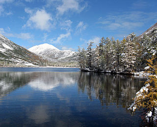
Lapland Nature Reserve is a Russian zapovednik in Murmansk Oblast, Russia, above the Arctic Circle. Officially established in 1957, the reserve protects an area of 2,784 km2 (1,075 sq mi) to the northwest of Lake Imandra, including 86 km² of inland water. The terrain is mountainous tundra and northern taiga. Since 1985 the zapovednik has been designated by UNESCO as a biosphere reserve. The name refers to the cultural area of Lapland, now preferably called Sápmi.

Poland is part of four terrestrial ecoregions, one freshwater ecoregion, and one marine ecoregion.

Central Siberia Nature Reserve is a Russian 'zapovednik'. With over 1 million hectares of protected area, it is one of the largest forest reserves in the world. The reserve is located in the middle Yenisei, lower Bakhta and lower Stony Tunguska river valleys, of the Central Siberian Plateau. Notably, the territory covers both banks of the Yenisei for over 60 km. The reserve is situated in the Turukhansky District of Krasnoyarsk Krai.

The wildlife of Finland is affected by prevailing environmental conditions. The phytogeography of Finland is shared between the Arctic, central European, and northern European provinces of the Circumboreal Region within the Boreal Kingdom. The territory of Finland can be subdivided into three ecoregions: the Scandinavian and Russian taiga, Sarmatic mixed forests, and Scandinavian montane birch forest and grasslands. Taiga covers most of Finland from northern regions of southern provinces to the north of Lapland. On the southwestern coast, south of the Helsinki-Rauma line, forests are mixed as is more typical in the Baltic region. In the extreme north of Finland, near the tree line and Arctic Ocean, montane birch forests are common.
Mordovski Nature Reserve is a Russian 'zapovednik' in the north of the Republic of Mordovia, on the forested right bank of the Moksha River. It is in the transition zone of coniferous-deciduous forests and steppe. The reserve covers one-sixth of the Temnikovsky District of Mordovia. It was formally established in 1935, and covers a total area of 32,148 ha (124.12 sq mi). Its official name honors Pyotr Smidovich, a Soviet revolutionary and government official who was instrumental in establishing the Mordovsky Reserve.

Kologrivski Forest Nature Reserve is a Russian 'zapovednik' created to protect and study southern taiga nature complexes of the Russian Plain. The reserve includes the only two surviving old-growth southern European taiga arrays not exposed landscape changes. Some trees are 350–400 years old. The reserve hosts 38 out of 72 species of rare and endangered species in the Kostroma region. The reserve is situated in the Kologrivsky District of Kostroma Oblast. It was formally established in 2006, and is officially named State Nature Reserve "MG Sinitsyn", after its first administrator. The site covers 58,940 ha (227.6 sq mi).
The Okhotsk-Manchurian taiga ecoregion is an area of coniferous forests in the Russian Far East, covering the Amur River delta, the west coast of the Okhotsk Sea, and the rugged extension of the northern Sikhote-Alin Mountains that run southwest-to-northeast through the Primorsky and Khabarovsk regions. It is the southernmost taiga forest in Eurasia. The ecoregion is distinguished from surrounding ecoregions by the slightly warmer climate due to the maritime influence and the shield of the mountains to the west, and by the mixing of flora and fauna species from Okhotsk-Kamchatka communities to the north and Manchurian species from the south. The forest at lower altitudes is "light taiga", and "dark taiga" at higher altitudes.
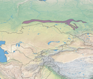
The West Siberian broadleaf and mixed forests, also known as the Western Siberian hemiboreal forests, is an ecoregion in Russia. It consists of a thin band of mixed forest along the southernmost edge of the West Siberian taiga in Western Siberia, and north of the forest steppe belt. The biodiversity of the zone is the highest in Siberia, due to its transitional position between many different ecoregions. The area acts as a long corridor for migration of animals along the east-west axis. The ecoregion is in the Palearctic realm, with a Humid Continental climate. It covers 223,516 km2 (86,300 sq mi).

The Central European mixed forests ecoregion is a temperate hardwood forest covering much of northeastern Europe, from Germany to Russia. The area is only about one-third forested, with pressure from human agriculture leaving the rest in a patchwork of traditional pasture, meadows, wetlands. The ecoregion is in the temperate broadleaf and mixed forest biome, and the Palearctic realm, with a Humid Continental climate. It covers 731,154 km2 (282,300 sq mi).

The Carpathian montane conifer forests, also known as Carpathian montane forests, is a temperate coniferous forests ecoregion in the Carpathian Mountains of the Czech Republic, Poland, Slovakia, Romania, and Ukraine.


