| Saskatoon Public Schools (Saskatoon S.D. No. 13) | |
|---|---|
| | |
| Location | |
310 21st St E, Saskatoon, SK S7K 1M7 Canada | |
| Coordinates | 52°07′37″N106°39′44″W / 52.126873°N 106.662188°W |
| District information | |
| Type | Public |
| Motto | Inspiring Learning |
| Grades | Pre-Kindergarten to Grade 12 |
| Schools | 58 |
| Budget | CA$308 million |
| Students and staff | |
| Students | 28,858 |
| Staff | Approx. 3,300 |
| Other information | |
| Director of Education | Shane Skjerven [1] |
| Board of Directors Chairperson | Kim Stranden [2] |
| Teachers' Union | Saskatchewan Teachers' Federation |
| Website | Saskatoon Public Schools |
Saskatoon Public Schools (SPS) or Saskatoon S.D. No. 13 is the largest school division in Saskatchewan serving 28,858 [3] students as of September 2025. Saskatoon Public Schools operates 47 elementary schools, one alliance school (Charles Red Hawk Elementary School on the Whitecap Dakota Nation), and 10 secondary schools in Saskatoon.
Contents
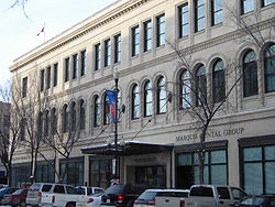
SPS is overseen by a Board of Trustees. [4] The Saskatoon Public Schools Board is responsible for shaping the overall educational vision for its schools and for developing and upholding policies that guide the division. The board’s administrative offices are located in the historic Eaton's Building. [5]
Saskatoon Public Schools are multicultural and multi-faith[ citation needed ]. SPS has been recognized as a leader in literacy as well as for its unique program offerings. Some of these unique programs include:
- French Immersion
- Montessori
- Nêhiyâwiwin Cree Language and Culture
- Métis/Michif Cultural Program
- English as an Additional Language
- Nature-Based Learning
- Flexible/Blended Learning
- Intergenerational Classroom
- Saskatoon Academically Gifted Education (SAGE)
- Creative Action (Arts)
- Ecoquest (Ecological Outdoor Adventure)
- Let's Lead - Nīkānētān (Experiential Learning)
- ScienceTrek (Field-Based Science)[ citation needed ]


