Savannah, Ohio

Last updated

Savannah, Ohio
Savannah South Main houses.jpg
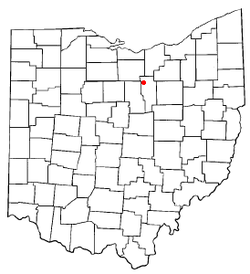
OHMap-doton-Savannah.png
Location of Savannah, Ohio
Map of Ashland County Ohio Highlighting Savannah Village.png
Location of Savannah in Ashland County
Coordinates: 40°58′05″N82°22′15″W / 40.96806°N 82.37083°W / 40.96806; -82.37083
Country United States
State Ohio
County Ashland
Area
[1]
  Total0.57 sq mi (1.47 km2)
  Land0.56 sq mi (1.45 km2)
  Water0.01 sq mi (0.02 km2)
Elevation
[2]
1,102 ft (336 m)
Population
 (2020)
  Total329
  Density587.50/sq mi (226.67/km2)
Time zone UTC-5 (Eastern (EST))
  Summer (DST) UTC-4 (EDT)
ZIP code
44874
Area code 419
FIPS code 39-70576 [3]
GNIS feature ID2399764 [2]
Website www.savannahohio.com/index.html

Savannah is a village in Ashland County, Ohio, United States. The population was 329 at the 2020 census.

Contents

History

Former school Savannah village school.jpg
Former school

Savannah was laid out in 1818. [4] A post office called Savannah has been in operation since 1839. [5]

Geography

Savannah is located along the Vermilion River.

According to the United States Census Bureau, the village has a total area of 0.58 square miles (1.50 km2), of which 0.57 square miles (1.48 km2) is land and 0.01 square miles (0.03 km2) is water. [6]

Demographics

Historical population
CensusPop.Note
1860 2,230
1870 394−82.3%
1880 342−13.2%
1890 325−5.0%
1900 290−10.8%
1910 262−9.7%
1920 2682.3%
1930 33826.1%
1940 3585.9%
1950 40713.7%
1960 4090.5%
1970 361−11.7%
1980 351−2.8%
1990 3633.4%
2000 3722.5%
2010 41311.0%
2020 329−20.3%
U.S. Decennial Census [7]

2010 census

As of the census [8] of 2010, there were 413 people, 139 households, and 108 families living in the village. The population density was 724.6 inhabitants per square mile (279.8/km2). There were 152 housing units at an average density of 266.7 per square mile (103.0/km2). The racial makeup of the village was 97.3% White, 1.2% African American, 1.0% Native American, and 0.5% from two or more races. Hispanic or Latino people of any race were 1.7% of the population.

There were 139 households, of which 41.7% had children under the age of 18 living with them, 55.4% were married couples living together, 14.4% had a female householder with no husband present, 7.9% had a male householder with no wife present, and 22.3% were non-families. 20.1% of all households were made up of individuals, and 8.7% had someone living alone who was 65 years of age or older. The average household size was 2.97 and the average family size was 3.39.

The median age in the village was 33.3 years. 29.8% of residents were under the age of 18; 7.5% were between the ages of 18 and 24; 27.8% were from 25 to 44; 25.4% were from 45 to 64; and 9.4% were 65 years of age or older. The gender makeup of the village was 49.4% male and 50.6% female.

2000 census

As of the census [3] of 2000, there were 372 people, 134 households, and 103 families living in the village. The population density was 839.1 inhabitants per square mile (324.0/km2). There were 147 housing units at an average density of 331.6 per square mile (128.0/km2). The racial makeup of the village was 99.46% White, 0.27% African American and 0.27% Native American.

There were 134 households, out of which 38.8% had children under the age of 18 living with them, 62.7% were married couples living together, 6.7% had a female householder with no husband present, and 23.1% were non-families. 18.7% of all households were made up of individuals, and 8.2% had someone living alone who was 65 years of age or older. The average household size was 2.78 and the average family size was 3.20.

In the village, the population was spread out, with 30.1% under the age of 18, 9.4% from 18 to 24, 33.1% from 25 to 44, 18.0% from 45 to 64, and 9.4% who were 65 years of age or older. The median age was 33 years. For every 100 females there were 101.1 males. For every 100 females age 18 and over, there were 101.6 males.

The median income for a household in the village was $35,469, and the median income for a family was $38,182. Males had a median income of $33,333 versus $21,250 for females. The per capita income for the village was $14,546. About 8.7% of families and 9.6% of the population were below the poverty line, including 13.3% of those under age 18 and 14.7% of those age 65 or over.

Notable people

Related Research Articles

<span class="mw-page-title-main">Ashland County, Ohio</span> County in Ohio, United States

Ashland County is a county located in the northeastern portion of the U.S. state of Ohio. As of the 2020 census, the population was 52,447. Its county seat and largest city is Ashland. The county is named for "Ashland", the home of Senator Henry Clay near Lexington, Kentucky. It was formed in 1846 from parts of Huron, Lorain, Richland and Wayne Counties.

<span class="mw-page-title-main">Ashland, Illinois</span> Village in Illinois, United States

Ashland is a village in Cass County, Illinois, United States. The population was 1,218 at the 2020 census.

<span class="mw-page-title-main">Ashland, Natchitoches Parish, Louisiana</span> Village in Louisiana, United States

Ashland is a village in the northernmost portion of Natchitoches Parish, Louisiana, United States. A few residences and a convenience store to the north spill over into neighboring Bienville Parish. The population was 291 at the 2000 census but declined nine percent to 269 in 2010. The median age was 45.7 years. Ashland is part of the Natchitoches Micropolitan Statistical Area.

<span class="mw-page-title-main">Ashland, Maine</span> Town in Maine, United States

Ashland is a town in Aroostook County, Maine, United States. The population was 1,202 at the 2020 census.

Ashland Township is a township in Dodge County, Minnesota, United States. The population was 367 at the 2000 census.

<span class="mw-page-title-main">Ashland, Missouri</span> City in Missouri, United States

Ashland is a city in Boone County, Missouri, United States. Ashland is part of the Columbia, Missouri Metropolitan Statistical Area. The population was 4,747 at the 2020 census.

<span class="mw-page-title-main">Ashland, Nebraska</span> City in Saunders County, Nebraska, United States

Ashland is a city in Saunders County, Nebraska, United States. The population was 3,086 at the 2020 census.

<span class="mw-page-title-main">Ashland, New Jersey</span> Populated place in Camden County, New Jersey, US

Ashland is an unincorporated community and census-designated place (CDP) located within Cherry Hill, in Camden County, in the U.S. state of New Jersey. As of the 2010 United States Census, the CDP's population was 8,302.

<span class="mw-page-title-main">Bailey Lakes, Ohio</span> Village in Ohio, United States

Bailey Lakes is a village in Clear Creek Township, Ashland County, Ohio, United States. The population was 349 at the 2020 census.

<span class="mw-page-title-main">Hayesville, Ohio</span> Village in Ohio, United States

Hayesville is a village in Vermillion Township, Ashland County, Ohio, United States. The population was 447 at the 2020 census.

<span class="mw-page-title-main">Mifflin, Ohio</span> Village in Ohio, United States

Mifflin is a village in Mifflin Township, Ashland County, Ohio, United States. The population was 158 at the 2020 census.

<span class="mw-page-title-main">Polk, Ohio</span> Village in Ohio, United States

Polk is a village in Ashland County, Ohio, United States. The population was 310 at the 2020 census.

<span class="mw-page-title-main">Athalia, Ohio</span> Village in Ohio, United States

Athalia is a village in Lawrence County, Ohio, United States, along the Ohio River. The population was 279 at the 2020 census.

<span class="mw-page-title-main">Hanging Rock, Ohio</span> Village in Ohio, United States

Hanging Rock is a village in Lawrence County, Ohio, United States, along the Ohio River. The population was 204 at the 2020 census.

<span class="mw-page-title-main">Clinton, Ohio</span> Village in Ohio, United States

Clinton is a village in southwestern Summit County, Ohio, United States. The population was 1,197 at the 2020 Census. It is part of the Akron metropolitan area.

<span class="mw-page-title-main">Ashland Heights, South Dakota</span> CDP in South Dakota, United States

Ashland Heights is a census-designated place (CDP) and unincorporated community in Pennington County, South Dakota, United States. The population was 678 at the 2020 census.

<span class="mw-page-title-main">Agenda, Wisconsin</span> Town in Wisconsin, United States

Agenda is a town in Ashland County in the U.S. state of Wisconsin. The population was 422 at the 2010 census. The unincorporated communities of Holts Landing and Petes Landing are located in the town.

<span class="mw-page-title-main">Peeksville, Wisconsin</span> Town in Wisconsin, United States

Peeksville is a town in Ashland County in the U.S. state of Wisconsin. The population was 141 at the 2010 census.

Ashland is a town in Ashland County, Wisconsin. The population was 594 at the time of the 2010 census. The city of Ashland, population 7,908, is located about 15 miles (24 km) northwest of the town. The unincorporated communities of High Bridge, Minersville, North York, and part of Jolmaville are located in the town.

<span class="mw-page-title-main">Mason, Wisconsin</span> Village in Wisconsin, United States

Mason is a village in Bayfield County, Wisconsin, United States. The population was 93 at the 2010 census. The village is located within the Town of Mason.

References

  1. "ArcGIS REST Services Directory". United States Census Bureau. Retrieved September 20, 2022.
  2. 1 2 U.S. Geological Survey Geographic Names Information System: Savannah, Ohio
  3. 1 2 "U.S. Census website". United States Census Bureau . Retrieved January 31, 2008.
  4. Baughman, Abraham J. (1909). History of Ashland County, Ohio, Volume 1. S. J. Clarke Publishing Company. p. 182.
  5. "Ashland County". Jim Forte Postal History. Retrieved December 27, 2015.
  6. "US Gazetteer files 2010". United States Census Bureau. Archived from the original on January 25, 2012. Retrieved January 6, 2013.
  7. "Census of Population and Housing". Census.gov. Retrieved June 4, 2015.
  8. "U.S. Census website". United States Census Bureau . Retrieved January 6, 2013.