
Golcar is a village on a hillside crest above the Colne Valley in the Kirklees district, in West Yorkshire, England, 3 miles (5 km) west of Huddersfield, and just north of the River Colne and the Huddersfield Narrow Canal.

Rastrick is a village in the county of West Yorkshire, England, between Halifax, 5 miles (8 km) north-west and Huddersfield, 4 miles (7 km) south.

Linthwaite is a village in the Kirklees district, in West Yorkshire, England. Historically part of the West Riding of Yorkshire, it is situated 4 miles (6.4 km) west of Huddersfield, on the A62 in the Colne Valley. The village together with Blackmoorfoot had a population of 3,835 according to the 2001 census.
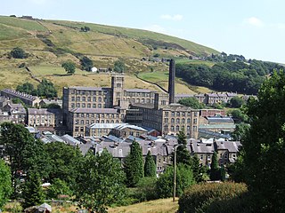
Marsden is a large village in the Colne Valley, in the metropolitan borough of Kirklees, West Yorkshire, England. It is in the South Pennines close to the Peak District which lies to the south. The village is 7 miles (11 km) west of Huddersfield at the confluence of the River Colne and Wessenden Brook. It was an important centre for the production of woollen cloth. In 2020, the village had an estimated population of 3,768.

Shelley is a village in the civil parish of Kirkburton, in the Kirklees district, in the county of West Yorkshire, England. The village is 3 miles (5 km) north of Holmfirth and 6 miles (10 km) south-east of Huddersfield.

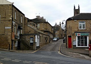
Slaithwaite is a town in the Kirklees district of West Yorkshire, England. Historically part of the West Riding of Yorkshire, it is in the Colne Valley and on the Huddersfield Narrow Canal, 5 miles (8 km) south-west of Huddersfield.

Hartshead is a village in the Kirklees district of West Yorkshire, England, 3.7 miles (6 km) west of Dewsbury and near to Hartshead Moor.
Honley is a village in the Holme Valley civil parish in Kirklees, West Yorkshire, England. Historically part of the West Riding of Yorkshire, it is situated near to Holmfirth and Huddersfield, and on the banks of the River Holme. According to the 2011 Census it had a population of 6,474, a growth of 577 from the 2001 Census

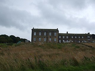
Deanhead Reservoir is a reservoir near Scammonden, in the metropolitan district of Kirklees, West Yorkshire, England.
Upperthong is a village approximately 807 feet (246 m) above sea level, in the civil parish of Holme Valley, in the Kirklees district, in West Yorkshire, England, near the town of Holmfirth, approximately 7 miles (11 km) south of Huddersfield. In 2005, Kirklees Council stated that the population of Upperthong was 1,116; by 2019, the figure was 1,938.

South Crosland is a village in the metropolitan borough of Kirklees in West Yorkshire, England.

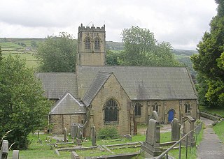
Holme is a village in the Holme Valley civil parish of Kirklees in West Yorkshire, England. The village straddles the A6024 road between Holmbridge and Lane village, 2.5 miles (4 km) south-west of Holmfirth. It is close to the boundaries of Derbyshire and the Peak District National Park: some properties lie outside of the National Park. Holme Moss, an area of high moorland with a prominent transmitter mast, overlooks the village from the south-west.

Greasbrough is a small suburb in Rotherham, in South Yorkshire, England. The suburb falls in the Greasbrough Ward of Rotherham Metropolitan Borough Council. Greasbrough had its own local council, Greasbrough UDC, until its absorption into the County Borough of Rotherham in 1936. Until 1974 it was in the West Riding of Yorkshire.

Flockton is a village in the civil parish of Kirkburton, in Kirklees, West Yorkshire, England. It is halfway between Huddersfield and Wakefield. In 2020, the population of Flockton and Flockton Green was estimated to be 2,107.

Netherthong is a village and former civil parish, now in the parish of Holme Valley, and the metropolitan borough of Kirklees in West Yorkshire, England. The village is near the town of Holmfirth, and on the B6107 road to Meltham from the main A6024 Woodhead Road through the Holme Valley from Honley to Holmfirth. It has an estimated population of 1,738 (2018).

Scammonden Reservoir is a water reservoir in West Yorkshire, England. Its water surface area when full is 42 hectares (0.16 sq mi). The level of the bellmouth overflow above sea level is 252 metres (827 ft). The reservoir holds 78,000,000,000 litres (1.7×10¹⁰ imp gal; 2.1×10¹⁰ US gal). Its length is 1.4 kilometres (0.9 mi).

Barkisland is a village in Calderdale, West Yorkshire, England. Historically part of the West Riding of Yorkshire, it is 1 mile (1.6 km) east of Ripponden, 2 miles (3.2 km) south of Sowerby Bridge and 4 miles (6.4 km) south-west of Halifax town centre.

Tinsley is a suburb of north-eastern Sheffield, South Yorkshire, England; it falls within the Darnall ward of the city.

Scammonden Bridge, also known locally as the Brown Cow Bridge, spans the Deanhead cutting carrying the B6114 Elland to Buckstones road over the M62 motorway in Kirklees, West Yorkshire, England. The bridge and Scammonden Reservoir to the west are named after Scammonden, the village that was flooded to accommodate the reservoir whose dam carries the motorway. On opening, the bridge was the longest concrete arch bridge in the UK.
Pole Moor is a hamlet between Outlane and Scammonden in Kirklees, England. It is situated on a high moorland plateau between Slaithwaite and Wholestone Moors in the South Pennines.

