Northfield is a town in Franklin County, Massachusetts, United States. Northfield was first settled in 1673. The population was 2,866 at the 2020 census. It is part of the Springfield, Massachusetts Metropolitan Statistical Area. The Connecticut River runs through the town, dividing West Northfield from East Northfield and the village of Northfield, where the town hall is located.
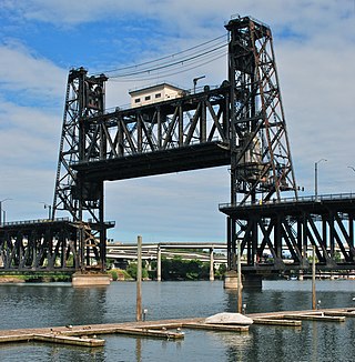
The Steel Bridge is a through truss, double-deck vertical-lift bridge across the Willamette River in Portland, Oregon, United States, opened in 1912. Its lower deck carries railroad and bicycle/pedestrian traffic, while the upper deck carries road traffic, and light rail (MAX), making the bridge one of the most multimodal in the world. It is the only double-deck bridge with independent lifts in the world and the second oldest vertical-lift bridge in North America, after the nearby Hawthorne Bridge. The bridge links the Rose Quarter and Lloyd District in the east to Old Town Chinatown neighborhood in the west.
The Calvin Coolidge Memorial Bridge is a major crossing of the Connecticut River in Western Massachusetts, connecting the towns of Northampton and Hadley. The bridge carries Route 9 across the river, where it connects to Interstate 91.

The Michigan Central Railway Bridge is an out-of-service steel Deck arch bridge spanning the Niagara Gorge between Niagara Falls, Ontario and Niagara Falls, New York. The bridge is owned by Canadian Pacific Kansas City, which purchased the single track structure in 1990. The Canadian corridor and bridge are owned by the City of Niagara Falls, Ontario. The bridge is located just upstream from the older arch-style Whirlpool Rapids Bridge used by Maple Leaf Amtrak passenger trains.
The Military Order of the Purple Heart Bridge, named after the Military Order of the Purple Heart, carries U.S. Route 40 and US 250 over the Ohio River back channel between Wheeling Island, West Virginia and Bridgeport, Ohio. Construction began in 1995 and finished in 1998.

The Norwottuck Rail Trail Bridge is a former crossing of Boston and Maine Railroad over the Connecticut River in western Massachusetts, connecting the towns of Northampton and Hadley, by the Norwottuck Rail Trail, which is currently used for bicycle and foot traffic.

The Hampden County Memorial Bridge is a reinforced-concrete arch bridge that spans the Connecticut River between Springfield, Massachusetts and West Springfield, Massachusetts, constructed in 1922. The bridge is owned by Massachusetts Highway Department and is located on Massachusetts Route 147. It spans 209 feet (64 m) and rises 29.71 feet (9.06 m) above the river.

The Canalside Rail Trail Bridge is a former New York, New Haven and Hartford Railroad rail bridge across the Connecticut River between Deerfield and Montague, Massachusetts. The bridge is on the Massachusetts Historic Bridge Inventory as a "Historic Metal Truss Bridge", currently the sixth oldest metal truss bridge on the state-wide historic registry. The Canalside Rail Trail, completed in Spring 2008, incorporates this bridge.

The Willimansett Bridge is a steel truss bridge over the Connecticut River located between Chicopee, Massachusetts and Holyoke, Massachusetts. It carries Massachusetts state routes 116 and 141.

The B & O Railroad Potomac River Crossing is a 15-acre (6.1 ha) historic site where a set of railroad bridges, originally built by the Baltimore and Ohio Railroad, span the Potomac River between Sandy Hook, Maryland and Harpers Ferry, West Virginia. The site was added to the National Register of Historic Places on February 14, 1978, for its significance in commerce, engineering, industry, invention, and transportation.

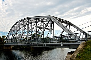
The Route 10 bridge, also known as Bennett's Meadow Bridge is a 215.5-metre (707 ft) steel stringer bridge crossing the Connecticut River in the town of Northfield, Massachusetts. The bridge carries state highway Route 10 and was built in 1969.

The Bellows Falls Arch Bridge was a three-hinged steel through arch bridge over the Connecticut River between Bellows Falls, Vermont and North Walpole, New Hampshire. It was structurally significant as the longest arch bridge in the United States when it was completed in 1905.

The Charleroi–Monessen Bridge, officially the John K. Tener Memorial Bridge, is a two lane structure spanning the Monongahela River. The bridge connects North Charleroi in Washington County, Pennsylvania and Monessen in Westmoreland County, Pennsylvania. The structure connects Route 88 on the west bank of the river and Route 906 on the east side. The bridge, which opened in 2013, replaced a 1906 structure. The original bridge closed in 2009 due to structural deficiency.

The Healdsburg Memorial Bridge is a steel truss bridge across the Russian River in Healdsburg, California, listed in the National Register of Historic Places. It can be seen from nearby U.S. Route 101 and is "Healdsburg's abiding structural symbol".
The Piermont Bridge carries New Hampshire Route 25 over the Connecticut River to the contiguous Vermont Route 25 between Piermont, New Hampshire and Bradford, Vermont. It is a Pennsylvania steel through truss bridge, built by the Boston Bridge Works in 1928. The bridge consists of a single span with a clear span of 352' and an overall length of 354'10". The roadbed is 20'7" wide, with a vertical clearance of 14'7". The bridge is approximately 25' above the river. The western (Vermont) abutment is made of split granite quarried from nearby Fairlee Mountain, while the eastern abutment is an early concrete construction built in 1908 by John Storrs for an earlier bridge. The bridge underwent a major renovation in 1993 which included the addition of a sidewalk and replacement of much of the bridge decking.

The Ranger Bridge between Wells River, Vermont and Woodsville, New Hampshire, is a three-hinged steel arch truss bridge over the Connecticut River. It was built in 1923 to replace a 1917 bridge and is the oldest steel arch bridge over the Connecticut River.

The Wells River Bridge between Wells River, Vermont and Woodsville, New Hampshire, is a steel double-decked Baltimore truss bridge over the Connecticut River. It was built in 1903 to carry rail and road traffic.

The Cold River Bridge was a historic bridge that carried Vermont Route 7B (VT 7B) across the Cold River in Clarendon, Vermont. The bridge, a steel Parker through truss, was built by the American Bridge Company in 1928, and was one of many bridges built in the state in the wake of devastating 1927 floods. It carried U.S. Route 7 (US 7) until bypassed by a bridge to the east, and was closed in 1989. It was listed on the National Register of Historic Places in 1991. It was subsequently demolished after a report noting substantial failures.

The Murrumbidgee River railway bridge is a heritage-listed railway bridge across the Murrumbidgee River located on the Tumut railway line at Gundagai in the Cootamundra-Gundagai Regional Council local government area of New South Wales, Australia. It was built in 1903. It is also known as the Gundagai Rail Bridge over Murrumbidgee River and the Murrumbidgee River Railway Bridge. The property was added to the New South Wales State Heritage Register on 2 April 1999.

The Terminal Bridge was a pontoon bridge and then a through-truss swing bridge at Leavenworth, Kansas. The pontoon bridge opened in 1889. The steel truss bridge opened on January 2, 1894, and was demolished in 1987.