South Yorkshire is a metropolitan county in England. It is the southernmost county in the Yorkshire and the Humber region and had a population of 1.34 million in 2011. It has an area of 1,552 square kilometres (599 sq mi) and consists of four metropolitan boroughs, Barnsley, Doncaster, Rotherham and Sheffield. South Yorkshire was created on 1 April 1974 as a result of the Local Government Act 1972. Its largest settlement is Sheffield.

Anston is a civil parish in South Yorkshire, England, formally known as North and South Anston. The parish of Anston consists of the settlements of North Anston and South Anston, divided by the Anston Brook.

Woodsetts is a village and civil parish in the Metropolitan Borough of Rotherham in South Yorkshire, England, on the border with Nottinghamshire. It lies between the towns of Dinnington and Worksop at an elevation of around 60 metres above sea level, and has a population of 1,802 reducing to 1,746 at the 2011 Census.

Maltby is a former mining town and civil parish of 16,688 inhabitants (2011) in the Metropolitan Borough of Rotherham, South Yorkshire, England. It was historically in the West Riding of Yorkshire. It is located about 6 miles (10 km) east of Rotherham town centre and 10 miles (16 km) north-east of Sheffield city centre. It forms a continuous urban area with Hellaby, separated from the rest of Rotherham by the M18 motorway.

Birdwell is a village in the Metropolitan Borough of Barnsley in South Yorkshire, England and is located approximately 4.5 miles (7 km) south of Barnsley, 12.1 miles (19 km) north-east of Sheffield, and 20.0 miles (32 km) west of Doncaster. The village falls within the Rockingham Ward of the Barnsley Metropolitan Council. Neighbouring villages include Worsbrough, Tankersley and Hoyland Common.

Treeton is a village and civil parish of the Metropolitan Borough of Rotherham in South Yorkshire, England. It is located about 4 miles (6 km) south of the town of Rotherham and 5 miles (8 km) east of Sheffield City Centre.

Barwick-in-Elmet is a village in West Yorkshire, 7 miles (11 km) east of Leeds city centre. It is one of only three places in the area to be explicitly associated with the ancient Romano-British kingdom of Elmet, the others being Scholes-in-Elmet and Sherburn-in-Elmet.
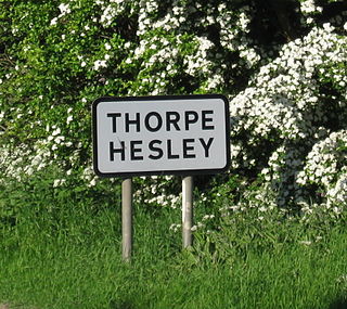
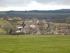
Thorpe Hesley is a village in the Metropolitan Borough of Rotherham, South Yorkshire, England, lying east of the M1 motorway at junction 35. The village has been included within the boundaries of Rotherham town since 1894, having previously been divided between the townships of Kimberworth and Wentworth. Historically the village was known for coal mining and nail making. It has an Anglican church, Holy Trinity, built in 1839 chiefly at the cost of Earl Fitzwilliam and the Earl of Effingham.
Catcliffe is a village and civil parish on the north-west bank of the River Rother in South Yorkshire, England. The population of the civil parish at the 2011 census was 2,108. It is in the Metropolitan Borough of Rotherham, approximately 2.5 miles (4 km) south of the town of Rotherham and 4.3 miles (7 km) east of Sheffield City Centre.

The Roman Rig is the name given to a series of earthworks in the north of Rotherham in South Yorkshire, England that are believed to originally have formed a single Dyke running from near Wincobank in Sheffield to Mexborough. Its purpose and date of construction are unknown. Formerly thought to have been a Roman road, modern archaeologists think that it was built either in the 1st century AD by the Brigantian tribes as a defence against the Roman invasion of Britain, or after the 5th century to defend the kingdom of Elmet from the Angles.

Keppel's Column is a 115-foot (35 m) tower Grade II* listed building between Wentworth and Kimberworth in Rotherham, South Yorkshire, England. Keppel's Column is one of several follies in and around Wentworth Woodhouse park; the others include Hoober Stand and Needle's Eye.
Scholes is a village near Cleckheaton, West Yorkshire, England.

Scholes Coppice in an area of ancient woodland located to the north-west of Kimberworth in the Metropolitan Borough of Rotherham in South Yorkshire, England. It was once part of the Kimberworth Deer Park, and contains a number of archaeological sites, the most significant of which is thought to be an Iron Age hill fort. Known as Caesar's Camp or Castle Holmes, this Scheduled Ancient Monument was partially excavated in the 1990s. It consists of an outer bank 2–5 metres high and 15 metres wide that may have been topped by a wooden palisade, which is paralleled by a 15-metre-wide ditch. There is no obvious entrance to the site.
Rotherham is a large minster town in South Yorkshire, England which along with its nearby settlements form the Metropolitan Borough of Rotherham, with a population of 257,280 in the 2011 census. Historically in the West Riding of Yorkshire, its central area is on the banks of the River Don below its confluence with the Rother on the traditional road between Sheffield and Doncaster. Rotherham was well known as a coal mining town as well as a major contributor to the steel industry. Traditional industries included glass making and flour milling.

Bramley is a village and civil parish of the Metropolitan Borough of Rotherham in South Yorkshire, England.

Scouting in Yorkshire and the Humber is largely represented by the Scout Association of the United Kingdom and some Groups of traditional Scouting including the Baden-Powell Scouts' Association.
Rotherham United Ladies Football Club is an English women's football club based in Rotherham, South Yorkshire. The club currently play in the North East Regional Women's League Premier Division.

Rotherham Metropolitan Borough Council is the local authority of the Metropolitan Borough of Rotherham in South Yorkshire, England. It is a metropolitan district council, one of four in South Yorkshire and one of 36 in the metropolitan counties of England. The council was created by the Local Government Act 1972.