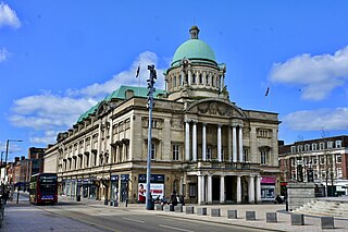
Kingston upon Hull, usually shortened to Hull, is a port city and unitary authority area in the East Riding of Yorkshire, England. It lies upon the River Hull at its confluence with the Humber Estuary, 25 miles (40 km) inland from the North Sea and 37 miles (60 km) south-east of York, the historic county town. With a population of 268,852 (2022), it is the fourth-largest city in the Yorkshire and the Humber region after Leeds, Sheffield and Bradford.
The East Riding of Yorkshire, often abbreviated to the East Riding or East Yorkshire, is a ceremonial county in the Yorkshire and the Humber region of England. It borders North Yorkshire to the north and west, South Yorkshire to the south-west, and Lincolnshire to the south across the Humber Estuary. The city of Kingston upon Hull is the largest settlement.

Haltemprice is an area in the East Riding of Yorkshire, England, directly to the west of Kingston upon Hull. Originally an extra-parochial area, it became a civil parish in 1858, in 1935 it was expanded by the combination of the urban districts of Cottingham, Anlaby, and Sculcoates to form a new urban district; the district included the villages of Anlaby, Cottingham, Hessle, Kirk Ella, Skidby, West Ella and Willerby. Urban districts were abolished 1974.
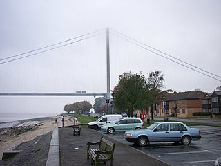
Hessle is a town, civil parish and electoral ward in the East Riding of Yorkshire, England, five miles west of Kingston upon Hull city centre. Geographically it is part of a larger urban area consisting of the city of Kingston upon Hull, the town of Hessle and a number of other villages but is not part of the city. It is on the north bank of the Humber Estuary where the Humber Bridge crosses.
Willerby is a village and civil parish located on the western outskirts of the city of Kingston upon Hull in the East Riding of Yorkshire, England.

Hull City Council, or Kingston upon Hull City Council, is the local authority for the city of Kingston upon Hull in the ceremonial county of the East Riding of Yorkshire, England. Hull has had a council since 1299, which has been reformed on numerous occasions. Since 1996 the council has been a unitary authority, being a district council which also performs the functions of a county council; it is independent from East Riding of Yorkshire Council, the unitary authority which administers the rest of the county.

Long Riston is a village in the civil parish of Riston, in the East Riding of Yorkshire, England, in an area known as Holderness. It is situated approximately 9 miles (14 km) north of Kingston upon Hull city centre and 6 miles (10 km) east of Beverley town centre. It lies to the east of the A165 road which by-passes the village. In 1931 the parish had a population of 266. On 1 April 1935 the parish was abolished to form Riston.

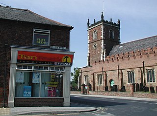
Kirk Ella is a village and civil parish on the western outskirts of Kingston upon Hull, approximately five miles west of the city centre, situated in the East Riding of Yorkshire, England. The parish includes West Ella.

Beverley Road is one of several major roads that run out of the city of Hull in the East Riding of Yorkshire, England. The road is noted for being a major arterial route into, and out of Hull. It also known for its student population and being the location of a shop (Turners), whose slogan was used by the pop band, Everything But the Girl. In 1994, just over 1-mile (1.6 km) of the road was designated as a conservation area.

Anlaby is a village forming part of the western suburbs of Kingston upon Hull, in the East Riding of Yorkshire, England. It forms part of the civil parish of Anlaby with Anlaby Common.

Endeavour Learning and Skills Centre is a centre operated by Hull Training & Adult Education offering adult education and further education.

Drypool is an area within the city of Kingston upon Hull, in the ceremonial county of the East Riding of Yorkshire, England.
Beverley was a rural district in the East Riding of Yorkshire, England from 1894 to 1974.
Sculcoates was a rural district in the East Riding of Yorkshire, England from 1894 to 1935.
The East Riding of Yorkshire is a local government district with unitary authority status, and is a ceremonial county of England. It is named after the historic East Riding of Yorkshire which was one of three ridings alongside the North Riding and West Riding, which were constituent parts a Yorkshire ceremonial and administrative county until 1974. From 1974 to 1996 the area of the modern East Riding of Yorkshire constituted the northern part of Humberside.

The Hull History Centre is an archive and local studies library in Hull, England. It houses the combined collections of both the Hull City Council and Hull University archives and local studies resources. This collaboration between Hull City Council, Hull University, and the Heritage Lottery Fund made Hull the first city in the UK to unite local council and university collections under one roof.
Sutton-on-Hull is a suburb of the city of Kingston upon Hull, in the ceremonial county of the East Riding of Yorkshire, England. It is located 3 miles (4.8 km) north east of the city centre and has the B1237 road running through it which connects the A165 road with the A1033.

Stepney is an area of Kingston upon Hull within the larger area of Sculcoates, north of the city centre on the (A1079) Beverley-Hull main road. Before the mid-19th century the place was a small hamlet outside the urban area of Kingston upon Hull.

Kingston General Hospital was an acute general hospital in Kingston upon Hull, England.
Sculcoates power station supplied electricity to Kingston upon Hull and the wider East Yorkshire area from 1898. An earlier 1893 station in Dagger Lane had operated public lighting in Hull Old Town. Sculcoates power station was built and operated by Kingston upon Hull Corporation on a site in Sculcoates Lane adjacent to the Beverley and Barmston Drain. The power station was increased in size as demand for electricity grew, it was redeveloped several times: including major rebuilds in 1927–29 and in 1938–1952. The power station was closed in 1976 and was subsequently demolished.

