Seasalter

Last updated

Seasalter
Admiralty Walk - geograph.org.uk - 1433198.jpg
Admiralty Walk
Kent UK location map.svg
Red pog.svg
Seasalter
Location within Kent
Population7,967 (2011) [1]
OS grid reference TR094653
District
Shire county
Region
Country England
Sovereign state United Kingdom
Post town Whitstable
Postcode district CT5 4
Dialling code 01227
Police Kent
Fire Kent
Ambulance South East Coast
UK Parliament
List of places
UK
England
Kent
51°20′44″N0°59′53″E / 51.3456°N 0.9981°E / 51.3456; 0.9981

Seasalter is a village (and district council ward) in the Canterbury district of Kent, England. Seasalter is on the north coast of Kent, between the towns of Whitstable and Faversham, facing the Isle of Sheppey across the estuary of the River Swale. The settlement of Yorkletts is included in the ward. It is approximately 6 miles (10 km) north of Canterbury.

Contents

History

Seasalter came to prominence as a centre for salt production in the Iron Age, [2] and the resulting prosperity resulted in Viking raids on the area. Later, the Domesday Book recorded that Seasalter "properly belongs to the kitchen of the Archbishop" [of Canterbury]. The church was dedicated to a martyred Archbishop of Canterbury, Alphege (Ælfheah), first built in the 12th century, its nave was demolished in the 1840s but its chancel still stands and is a Grade II listed building. [3] [4] In the 18th century, the marshes were drained to create the Seasalter Levels. [5]

St Alphege church, Seasalter St Alphege church, Seasalter, Kent - geograph.org.uk - 1009507.jpg
St Alphege church, Seasalter
Seasalter Beach Whitstable from Seasalter Beach.JPG
Seasalter Beach

In 1891 the civil parish had a population of 1397. [6] In 1894 the parish was abolished to form Whitstable Urban and Whitstable cum Seasalter. [7] It is now in the unparished area of Whitstable.

In 2017, the Old Brig, a well-preserved 18th century merchant ship wreck was exposed by tides near Seasalter. It is one of only three known coastal trading vessels in England from the Hanoverian period and was listed as a Scheduled Monument by Historic England in 2020. [8] [9]

Modern day

Seasalter today is primarily a residential satellite of Whitstable, and further housing development is unlikely as it is constrained by the sea, the Seasalter Flats protected marshland, and the A299 road. The beach at Seasalter is largely pebble-stone based, and therefore unpopular compared with the more sandy bays at, for example, Westgate-on-Sea. Seasalter Sailing Club, which has a clubhouse on Faversham Road, primarily hosts Catamaran boats which race on the Swale River estuary. There is also a private Water Ski Club with launch ramp, and a caravan park.

The Sportsman pub, at the western end of the village by the marshes, on a site which has hosted an inn since 1642, has maintained a Michelin star since 2008. [10] [11] During the Second World War it was the billet for a company of the 1st Battalion London Irish Rifles. In September 1940 these troops happened to successfully engage the crew of a crashed German airplane on nearby Graveney Marsh, and in 2010 to mark the 70th anniversary, a commemorative plaque was unveiled at the pub. [12]

Famous residents with homes or holiday houses in Seasalter include Gregg Wallace, Harry Hill and Janet Street-Porter. [13] The late Peter Cushing used to live further along the coast in Wave Crest, Whitstable.

Whitstable's Oyster Fishery uses [14] oyster beds lying in the mud approximately a mile offshore from the Seasalter. These are usually submerged and only revealed at low tide.

In 1976, a free rock festival was held in Seasalter after a forced move away from the chosen site in Tangmere. [15]

Transport

Despite the Chatham Main Line Railway passing through Seasalter, there is no station. It has long been proposed to build one, with railway maps noting a possible site; this is unlikely given the proximity of Whitstable Station. Currently the village is served by Stagecoach buses from Canterbury, Whitstable and Faversham.

Author Russell Hoban repurposes Seasalter as "Littl Salting" in his 1980, post apocalyptic novel Riddley Walker . [16]

Related Research Articles

<span class="mw-page-title-main">Whitstable</span> Town in Kent, England

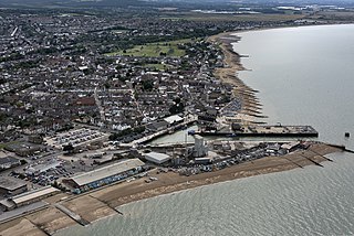
Whitstable is a town in the Canterbury district, on the north coast of Kent adjoining the convergence of the Swale Estuary and the Greater Thames Estuary in southeastern England, five miles north of Canterbury and two miles west of Herne Bay. The 2011 Census reported a population of 32,100.

<span class="mw-page-title-main">Faversham</span> Market town in England

Faversham is a market town in Kent, England, 8 miles (13 km) from Sittingbourne, 48 miles (77 km) from London and 10 miles (16 km) from Canterbury, next to the Swale, a strip of sea separating mainland Kent from the Isle of Sheppey in the Thames Estuary. It is close to the A2, which follows an ancient British trackway which was used by the Romans and the Anglo-Saxons, and known as Watling Street. The name is of Old English origin, meaning "the metal-worker's village".

<span class="mw-page-title-main">North Kent Marshes</span>

The North Kent Marshes are in the far north of the county of Kent spanning dry and wet south banks and inlets of the Thames Estuary in south-east England. The marshes are one of 22 Environmentally Sensitive Areas recognised by the UK's Department for Environment, Food and Rural Affairs (DEFRA). They are in the Thames Gateway regional planning area. They include the 5,289-hectare (20.4 sq mi) South Thames Estuary and Marshes biological SSSI.

<span class="mw-page-title-main">Canterbury (UK Parliament constituency)</span> UK Parliament constituency since 1295

Canterbury is a constituency in Kent represented in the House of Commons of the UK Parliament since 2017 by Rosie Duffield of the Labour Party.

<span class="mw-page-title-main">Boughton under Blean</span> Human settlement in England

Boughton under Blean is a village and civil parish between Faversham and Canterbury in south-east England. "Boughton under Blean" technically refers only to the hamlet at the top of Boughton Hill; the main village at the foot of the hill is named Boughton Street, but the whole is referred to as "Boughton under Blean" or more commonly as just "Boughton". The Blean refers to the Forest of Blean, an area of long-standing Kent woodland covering over 11 square miles.

<span class="mw-page-title-main">Harty</span> Human settlement in England

Harty is a small hamlet on the Isle of Sheppey in Kent consisting of a few cottages, a church and a public house, the Ferry Inn. It is part of the civil parish of Leysdown.

<span class="mw-page-title-main">Saxon Shore Way</span> Long-distance footpath in England

The Saxon Shore Way is a long-distance footpath in England. It starts at Gravesend, Kent, and traces the coast of South-East England as it was in Roman times as far as Hastings, East Sussex, 163 miles (262 km) in total. This means that around Romney Marsh the route runs significantly inland from the modern coastline.

<span class="mw-page-title-main">Teynham</span> Human settlement in England

Teynham is a large village and civil parish in the borough of Swale in Kent, England. The parish lies between the towns of Sittingbourne and Faversham, immediately north of the A2 road, and includes the hamlet of Conyer on an inlet of the Swale, the channel that separates mainland Kent from the Isle of Sheppey. Other hamlets include Deerton Street, Frognal, and Teynham Street.

<span class="mw-page-title-main">Molash</span> Human settlement in England

Molash is a civil parish and village in Kent, South East England. It contains a small part of an Area of Outstanding Natural Beauty (AONB) - the North Downs - and is on the A252 road between Canterbury, Ashford and Faversham. Each of these is centred 7 miles (11 km) away.

<span class="mw-page-title-main">Milton Regis</span> Human settlement in England

Milton Regis is a village in the district of Swale in Kent, England. Former names include Milton-next-Sittingbourne, Milton Royal, Middleton, Midletun and Middletune. It has a population of about 5,000. Today it is a suburb of Sittingbourne, although this has not always been the case. Until around 1800, Sittingbourne was a small hamlet and under the control of the Manor of Milton Regis.

<span class="mw-page-title-main">Swalecliffe</span> A coastal village in Kent, England

Swalecliffe is a part of the ribbon development of the north Kent coast between Whitstable and Herne Bay in Southeast England. It forms Swalecliffe ward of City of Canterbury Council.

<span class="mw-page-title-main">Bredgar</span> Human settlement in England

Bredgar is a village and civil parish in the Borough of Swale, Kent, England.

<span class="mw-page-title-main">Graveney</span> Human settlement in England

Graveney is a village and former civil parish, now in the parish of Graveney with Goodnestone, in the Swale district, in Kent, England. It is located between Faversham and Whitstable. The main part of the village is located along the intersection of Seasalter Road, Sandbanks Road and Head Hill Road, which is surrounded by farmland. The rest of the village is dispersed amongst this farmland. In 1961 the parish had a population of 305.

<span class="mw-page-title-main">Murston</span> Human settlement in England

Murston is a suburb of Sittingbourne, in the Swale district, in the county of Kent, England. It is about 1 mile north-east of central Sittingbourne, on the east bank of the Milton Creek.

Hernhill is a village and civil parish between Faversham and Canterbury in southeast England. The parish includes the hamlets of Crockham, Dargate, The Fostall, Lamberhurst, Oakwell, Staple Street, Thread, Waterham and Wey Street.

<span class="mw-page-title-main">Davington</span> Human settlement in England

Davington is a suburb of Faversham, in the Swale district, in the county of Kent, England.

<span class="mw-page-title-main">2017 Kent County Council election</span> 2017 UK local government election

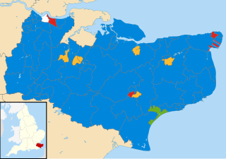
The 2017 Kent County Council election was held on 4 May 2017 as part of the 2017 local elections in the United Kingdom. All 81 councillors were elected from 72 electoral divisions, each of which returned either one or two county councillors by first-past-the-post voting for a four-year term of office. The Conservative Party retained control. UKIP, previously the second-largest party on the council, lost all their seats.

<span class="mw-page-title-main">Seasalter Levels</span> Nature reserve in Kent, England

Seasalter Levels is a 71.4-hectare (176-acre) Local Nature Reserve in Seasalter, on the western outskirts of Whitstable in Kent. It is owned and managed by Canterbury City Council. It is part of The Swale Ramsar site, Special Protection Area and Site of Special Scientific Interest.

References

  1. "Ward population 2011" . Retrieved 2 October 2015.
  2. St Alphege Church History
  3. "St Alphege Church, Seasalter in Whitstable - St Alphege Church, Seasalter - Part of the Anglican Whitstable Team Ministry". stalphegeseasalter.org. Retrieved 26 December 2020.
  4. "Seasalter Old Church, St Alphege, Non Civil Parish - 1084929 | Historic England". historicengland.org.uk. Retrieved 1 January 2021.
  5. History of Whitstable Shoreline
  6. "Population statistics Seasalter CP/AP through time". A Vision of Britain through Time . Retrieved 21 April 2024.
  7. "Blean Registration District". UKBMD. Retrieved 21 April 2024.
  8. "Wreck of Old Brig, Non Civil Parish - 1451624 | Historic England". historicengland.org.uk. Retrieved 26 December 2020.
  9. "Captivating Sites Across England Listed During 2020 | Historic England". historicengland.org.uk. Retrieved 26 December 2020.
  10. "Michelin stars and pints in Whitstable". The Guardian . 8 February 2008. Archived from the original on 29 November 2022.
  11. "The Sportsman – Seasalter - a MICHELIN Guide Restaurant". MICHELIN Guide. Retrieved 27 July 2021.
  12. "Kent battle between German bomber crew and British soldiers marked after 70 years". The Daily Telegraph . 20 August 2010. Archived from the original on 23 August 2010. Retrieved 31 August 2010.
  13. Telegraph Article about Whitstable
  14. Seasalter Shellfish
  15. Seasalter People's Free Festival
  16. "Places - Riddley Walker Annotations". Errorbar. Archived from the original on 29 July 2021. Retrieved 21 August 2022.