Related Research Articles
The eustatic sea level is the distance from the center of the Earth to the sea surface. An increase of the eustatic sea level can be generated by decreasing glaciation, increasing spreading rates of the mid-ocean ridges or increasing the number of mid-oceanic ridges. Conversely, increasing glaciation, decreasing spreading rates or fewer mid-ocean ridges can lead to a fall in the eustatic sea level.
Sequence stratigraphy is a branch of geology, specifically a branch of stratigraphy, that attempts to discern and understand historic geology through time by subdividing and linking sedimentary deposits into unconformity bounded units on a variety of scales. The essence of the method is mapping of strata based on identification of surfaces which are assumed to represent time lines, thereby placing stratigraphy in chronostratigraphic framework allowing understanding of the evolution of the earth's surface in a particular region through time. Sequence stratigraphy is a useful alternative to a purely lithostratigraphic approach, which emphasizes solely based on the compositional similarity of the lithology of rock units rather than time significance. Unconformities are particularly important in understanding geologic history because they represent erosional surfaces where there is a clear gap in the record. Conversely within a sequence the geologic record should be relatively continuous and complete record that is genetically related.

Lithostratigraphy is a sub-discipline of stratigraphy, the geological science associated with the study of strata or rock layers. Major focuses include geochronology, comparative geology, and petrology.

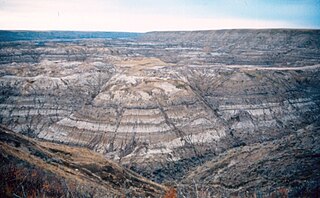
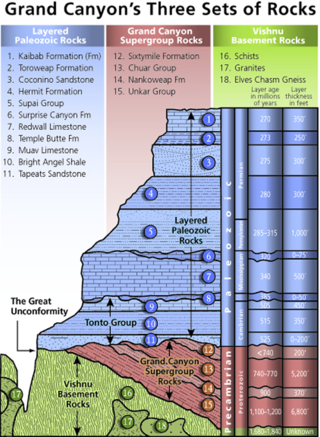
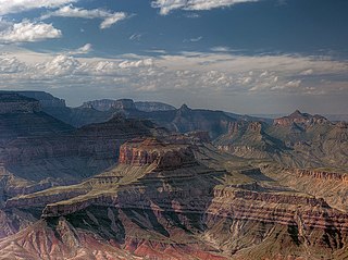
A cratonic sequence in geology is a very large-scale lithostratigraphic sequence in the rock record that represents a complete cycle of marine transgression and regression on a craton over geologic time. They are geologic evidence of relative sea level rising and then falling, thereby depositing varying layers of sediment onto the craton, now expressed as sedimentary rock. Places such as the Grand Canyon are a good visual example of this process, demonstrating the changes between layers deposited over time as the ancient environment changed.
In stratigraphy and geology, an eonothem is the totality of rock strata laid down in the stratigraphic record deposited during a certain eon of the continuous geologic timescale. The eonothem is not to be confused with the eon itself, which is a corresponding division of geologic time spanning a specific number of years, during which rocks were formed that are classified within the eonothem. Eonothems have the same names as their corresponding eons, which means during the history of the Earth only four eonothems were formed. Oldest to newest these are the Hadean, Archean, Proterozoic, and Phanerozoic. A rock stratum, fossil or feature present in the "upper Phanerozoic" eonothem would therefore have originated within the "later Phanerozoic" eon. In practice, the rock column is discontinuous:
Technically, a complete geologic record doesn't occur anywhere. For such a record to develop would require the area to have been receiving sedimentary deposits continually ever since the origin of the earth. Nowhere is such a situation known to exist. If it did exist, we could not effectively look at the strata because they would still be buried, and modern strata would continue to be deposited on top of them. The earth's surface has been far too dynamic to allow that to occur anywhere. No area has been in such a static condition throughout the earth's long history. Areas that have had sediment deposited on them at one time are later uplifted and eroded. In some places this has occurred many times. There is ample evidence to prove such a sequence of events.
A stratigraphic column is a representation used in geology and its subfield of stratigraphy to describe the vertical location of rock units in a particular area. A typical stratigraphic column shows a sequence of sedimentary rocks, with the oldest rocks on the bottom and the youngest on top.
The Neoproterozoic Nankoweap Formation, is a thin sequence of distinctive red beds that consist of reddish brown and tan sandstones and subordinate siltstones and mudrocks that unconformably overlie basaltic lava flows of the Cardenas Basalt of the Unkar Group and underlie the sedimentary strata of the Galeros Formation of the Chuar Group. The Nankoweap Formation is slightly more than 100 m in thickness. It is informally subdivided into informal lower and upper members that are separated and enclosed by unconformities. Its lower (ferruginous) member is 0 to 15 m thick. The Grand Canyon Supergroup, of which the Nankoweap Formation is part, unconformably overlies deeply eroded granites, gneisses, pegmatites, and schists that comprise Vishnu Basement Rocks.
The Taylorsville Basin is an early Mesozoic rift basin that either outcrops, or is present beneath younger deposits, in Virginia and Maryland. It is part of the chain of rift basins along the eastern part of North America that formed during the break-up of the Pangaea supercontinent. It is filled by a fluvial and lacustrine sedimentary sequence of the Newark Supergroup.
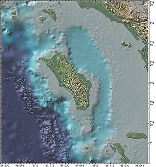
The Nias Basin is a forearc basin located off the western coast of Sumatra, Indonesia, in the Indian Ocean. The name is derived from the island that bounds its western edge, the island of Nias. The Nias Basin, the island of Nias, and the offshore, submarine accretionary complex, together form a Forearc region on the Sunda Plate/Indo-Australian Plate collisional/subduction boundary. The Forearc region is the area between an oceanic trench and its associated volcanic arc. The oceanic trench associated with the Nias Basin is the Sunda Trench, and the associated volcanic arc is the Sunda Arc.
Marine flooding surfaces are a fundamental concept in sequence stratigraphy, where they form the limiting surfaces of parasequences.
Accommodation is a fundamental concept in sequence stratigraphy, a subdiscipline of geology. It is defined as the space that is available for the deposition of sediments. Accommodation space can be pictured as the volume between the actual surface and the theoretical equilibrium surface where deposition and erosion are in balance at every point. In marine environments, this equilibrium level is sea level.
A parasequence is a fundamental concept of sequence stratigraphy. Parasequences are not directly related to sequences.
In geology, range offset is the time difference between the last fossil occurrence of a taxon and the actual disappearance of this taxon. Range offset can be used as a measure of biostratigraphic precision and determines among others how much information about extinctions can be derived from fossil occurrences.
In sequence stratigraphy, a maximum flooding surface is the surface that marks the transition from a transgression to a regression. Maximum flooding surfaces are abbreviated by mfs, synonyms for them include final transgressive surface, surface of maximum transgression and maximum transgressive surface.
In geology, a diastem is a short interruption in sedimentation with little or no erosion. They can also be described as very short unconformities. In 1917, Joseph Barrell estimated the rate of deposition of succession from the available radiometric age. His outcrops showed that the strata accumulation was at the rate of thousands of years per foot rather than hundreds. He stated that diastems are universal in sedimentary rocks and explained them as a product of fluctuation of base level.
In geology, a subaerial unconformity is a surface that displays signs of erosion by processes that commonly occur on the surface. These processes generating the subaerial unconformity can include wind degradation, pedogenesis, dissolution processes such as karstification as well as fluvial processes such as fluvial erosion, bypass and river rejuvenation.
Relative sea level is defined as the sea level that is observed with respect to a land-based reference frame. It is often contrasted with eustatic sea level, which is a measure of the total mass or volume of the oceans. Relative sea level can change by the processes changing eustatic sea level, but also by changes on land such as subsidence and isostatic rebound.

Steven M. Holland is an American paleontologist and geologist at the University of Georgia. His research focuses on stratigraphic paleobiology, the application of event and sequence stratigraphy to a paleobiological understanding of the fossil record. With Mark Patzkowsky, he coauthored the book Stratigraphic Paleobiology.
In sequence stratigraphy, a sub discipline of geology, type 1 sequences and type 2 sequences are special sequences that are defined by having distinct types of sequence boundaries. In modern literature, the distinction in type 1 sequences and type 2 sequences was abandoned.
Stratigraphic paleobiology is a branch of geology that is closely related to paleobiology, sequence stratigraphy and sedimentology. Stratigraphic paleobiology studies how the fossil record is altered by sedimentological processes and how this affects biostratigraphy and paleobiological interpretations of the fossil record.
References
- ↑ Catuneanu, Octavian (2011). "Sequence stratigraphy: methodology and nomenclature" (PDF). Newsletters on Stratigraphy. E. Schweizerbart'sche Verlagsbuchhandlung. 44 (3): 183. doi:10.1127/0078-0421/2011/0011.
- ↑ Patzkowsky, Mark E.; Holland, Steven M. (2012). Stratigraphic Paleobiology. Chicago: University of Chicago University Press. p. 220.
- ↑ Patzkowsky, Mark E.; Holland, Steven M. (2012). Stratigraphic Paleobiology. Chicago: University of Chicago University Press. pp. 42–43.
| | This article about stratigraphy is a stub. You can help Wikipedia by expanding it. |