The Kamay Botany Bay National Park is a heritage-listed protected national park that is located in the Sydney metropolitan region of New South Wales, in eastern Australia. The 456-hectare (1,130-acre) national park is situated approximately 16 kilometres (9.9 mi) south-east of the Sydney central business district, on the northern and southern headlands of Botany Bay. The northern headland is at La Perouse and the southern headland is at Kurnell.

Hat Head is a national park in New South Wales, Australia, 461.7 kilometres (286.9 mi) via M1 and Pacific Highway/A1, northeast of Sydney. It lies within the Hastings-Macleay Important Bird Area.

Myall Lakes National Park is a national park located in New South Wales, Australia, 236 kilometres (147 mi) north of Sydney. It encompasses one of the state's largest coastal lake systems Myall Lakes, and includes Broughton Island. The park includes 40 kilometres of beaches and rolling sand dunes. Myall Lakes is also one of the most visited parks in New South Wales.

The Royal National Park is a protected national park that is located in Sutherland Shire in the Australian state of New South Wales, just south of Sydney and is situated on Dharawal country.

Southwick Beach State Park is a New York State park that lies along an unusual stretch of sandy beach on the eastern shore of Lake Ontario. The park is 464 acres (188 ha) in size with a 3,500 foot (1,100 m) length of beach, and is visited annually by about 100,000 people. Immediately to the south is the Lakeview Wildlife Management Area, which extends the publicly accessible beach by several miles. They are in the Town of Ellisburg in Jefferson County, New York south of the lakeside community of Jefferson Park.

Sandy Bay is a village, bay and beach located on a small bay on the eastern Mediterranean coast of Gibraltar, on the opposite side of The Rock from the main city. It is situated to the south of Catalan Bay and is accessible via Sir Herbert Miles Road.
Puckey's Estate Reserve is a coastal nature reserve in North Wollongong, New South Wales, Australia. It is mainly she-oak forest, but also has sand dune and wetland areas, including areas along Para Creek. It is located in the suburb of Fairy Meadow and is bounded by Fairy Meadow Beach to the east, Squires Way to the west, Elliotts Road to the north and Fairy Lagoon to the south.
Indiana Dunes State Park is an Indiana State Park located in Porter County, Indiana, United States, 47 miles (75.6 km) east of Chicago. The park is bounded by Lake Michigan to the northwest, and is surrounded by as well as within the authorized boundaries of Indiana Dunes National Park, a unit of the National Park Service; the NPS owns the water from the ordinary high water mark to 300 feet (91 m) offshore. The 1,530-acre (619.2 ha) Dunes Nature Preserve makes up the bulk of eastern part of the park, and includes most of the park’s hiking trails and dune landscape. This was one of the first places Richard Lieber considered when establishing the Indiana State Park system. Like all Indiana state parks, there is a fee for entrance. Indiana Dunes State Park was established in 1925 and designated a National Natural Landmark in 1974.
Beecroft Peninsula is the northern headland of Jervis Bay, on Australia's east coast. On the western and southern sides of the peninsula steep sandstone cliffs rise out of the ocean, up to 91 metres at its southernmost point, Point Perpendicular. White sandy beaches are found along the northern, eastern and southern sides interspersed with numerous intertidal reefs.

Barrenjoey is a locality in the suburb of Palm Beach, at the most northern tip of Pittwater. The headland is made up primarily of sandstones of the Newport Formation, the top third is a cap of Hawkesbury sandstone. Around 10,000 years ago the headland was cut off from the mainland due to the rising sea level; subsequent buildup of a sand spit or tombolo reconnected the island to the mainland. It is the location of the Barrenjoey Head Lighthouse, a lighthouse that was first lit in 1881. In 1995 Barrenjoey was gazetted into Ku-ring-gai Chase National Park.

The Swan Coastal Plain in Western Australia is the geographic feature which contains the Swan River as it travels west to the Indian Ocean. The coastal plain continues well beyond the boundaries of the Swan River and its tributaries, as a geological and biological zone, one of Western Australia's Interim Biogeographic Regionalisation for Australia (IBRA) regions. It is also one of the distinct physiographic provinces of the larger West Australian Shield division.
Banksia integrifolia, commonly known as coast banksia, is a species of tree that grows along the east coast of Australia. One of the most widely distributed Banksia species, it occurs between Victoria and Central Queensland in a broad range of habitats, from coastal dunes to mountains. It is highly variable in form, but is most often encountered as a tree up to 25 metres (82 ft) in height. Its leaves have dark green upper surfaces and white undersides, a contrast that can be striking on windy days.

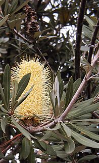
Banksia aemula, commonly known as the wallum banksia, is a shrub of the family Proteaceae. Found from Bundaberg south to Sydney on the Australian east coast, it is encountered as a shrub or a tree to 8 m (26 ft) in coastal heath on deep sandy soil, known as Wallum. It has wrinkled orange bark and shiny green serrated leaves, with green-yellow flower spikes, known as inflorescences, appearing in autumn. The flower spikes turn grey as they age and large grey follicles appear. Banksia aemula resprouts from its woody base, known as a lignotuber, after bushfires.

Eucalyptus botryoides, commonly known as the bangalay, bastard jarrah, woollybutt or southern mahogany, is a small to tall tree native to southeastern Australia. Reaching up to 40 metres high, it has rough bark on its trunk and branches. It is found on sandstone- or shale-based soils in open woodland, or on more sandy soils behind sand dunes. The white flowers appear in summer and autumn. It reproduces by resprouting from its woody lignotuber or epicormic buds after bushfire. E. botryoides hybridises with the Sydney blue gum in the Sydney region. The hard, durable wood has been used for panelling and flooring.
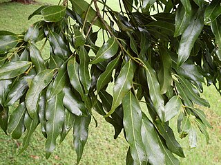
Cinnamomum oliveri is a rainforest tree growing at the eastern coastal parts of Australia. It grows from the Illawarra district in New South Wales to Cape York Peninsula at the northern tip of Australia. The southernmost limit of natural distribution is on the volcanic cliffs above the town of Gerroa and nearby on the sand in rainforest behind Seven Mile Beach, New South Wales.

The Littoral Rainforests of New South Wales is a group of fragmented and endangered ecological communities found by the coast in eastern Australia. Much of this seaside form has been destroyed by mining, tourist development or housing. It is threatened by extinction in the near future. 90% of the 433 sites are less than ten hectares in size. Littoral rainforest amounts to 0.6% of the rainforests in New South Wales.
The Federation Walk Coastal Reserve is a reserve comprising the eastern part of The Spit on the Gold Coast, Queensland, Australia. The reserve was opened on 22 June 2003, and is approximately 93 hectares in size. The area supports a subtle mix of habitats including littoral rainforest, native grasslands, and pockets of wetlands. The Federation Walk track goes throughout the reserve.

The ecology of Sydney, located in the state of New South Wales, Australia, is diverse for its size, where it would mainly feature biomes such as grassy woodlands and some sclerophyll forests, with a few pockets of mallee shrublands, subtropical and temperate rainforests (evergreen), heathlands, and wetlands. The combination of climate, topography, moisture, and soil influence the dispersion of these ecological communities across a height gradient from 0 to 200 metres. There are many hiking trails, paved and unpaved roads for exploring the many different biomes and ecosystems.

Wide Bay Military Reserve is a heritage-listed military installation at Tin Can Bay Road, Tin Can Bay, Queensland, Australia. The reserve supports a diverse range of plant communities from estuarine, strand, wetlands, heath, tall shrublands and woodlands, to the open forests of the sub-coastal hills and ranges. The total number of bird species recorded for the place totals 250, which is high by Australian standards. It was added to the Australian Commonwealth Heritage List on 22 June 2004.

Limeburners Creek National Park is a protected national park on the Mid North Coast of New South Wales, Australia. The 91.2 km national park is located 5 km (3.1 mi) to the north of Port Macquarie and exists across both the Kempsey Shire and Port Macquarie-Hastings Council local government areas, but is chiefly managed by National Parks and Wildlife Service. The area was originally erected as a nature reserve but this reservation was revoked when it became formally recognised as a national park in 2010 under the National Parks and Wildlife Act (1974). Many threatened ecological habitats and species of fauna and flora are found within this park, alongside several heritage sites of cultural significance, particularly to the local Birpai and Dunghutti people upon whose land the park exists. The protected status of this national park is largely owing to the ecological and cultural value of the area, in addition to the value of the ecosystems to further scientific research.